Fichtelnaab
The Fichtelnaab is a river in Upper Franconia and the Upper Palatinate, Bavaria, Germany. It rises in the Fichtelgebirge and flows into the Waldnaab near Windischeschenbach.
| Fichtelnaab | |
|---|---|
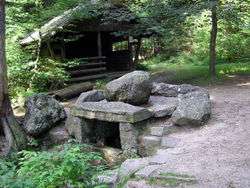 Source of the Fichtelnaab | |
| Location | |
| Location | Bayreuth district, Tirschenreuth district |
| Reference no. | DE: 1412 |
| Physical characteristics | |
| Source | |
| • location | on the southeastern slopes of the Ochsenkopf |
| • coordinates | 50°01′31″N 11°50′01″E |
| • elevation | ca. 865 m |
| Mouth | |
• location | near Windischeschenbach into the Waldnaab |
• coordinates | 49°48′30″N 12°09′44″E |
• elevation | 423 m |
| Length | 47.4 km (29.5 mi) [1] |
| Basin size | 278 km2 (107 sq mi) [1] |
| Basin features | |
| Progression | Waldnaab→ Naab→ Danube→ Black Sea |
| Tributaries | |
| • left | Gregnitz |
Course
The source of the Fichtelnaab is located on the southeastern slope of the Ochsenkopf (1,024 m above sea level (NN)) northwest of Fichtelberg and west of the Fichtelsee (10.5 hectares and 752 m above NN). From there it flows southeast through the villages of Fichtelberg and Mehlmeisel in the district of Tirschenreuth. From there the Fichtelnaab passes through Brand, Ebnath, Neusorg and Erbendorf to Windischeschenbach, where it joins the Waldnaab.
Tributaries
- Moosbach (right)
- Kratzebach (left)
- Fallbach (right)
- Geisbach (right)
- Fuhrbach (left)
- Saugrabenbach (right)
- Gregnitz (left)
- Goldbach (right)
- Witzelbach (right)
- Höllbach (left)
- Felberger Bach (right)
- Forellenbach (left)
- Tiefenbach (right)
- Galgenbach (right)
- Steinbach (right)
- Heinbach (left)
Sources
- Die Naab – mit Waldnaab, Fichtelnaab, Haidenaab. 144 Seiten, Pustet, Regensburg,ISBN 3-7917-1915-7.
References
- Complete table of the Bavarian Waterbody Register by the Bavarian State Office for the Environment (xls, 10.3 MB)
This article is issued from Wikipedia. The text is licensed under Creative Commons - Attribution - Sharealike. Additional terms may apply for the media files.