Fersfield
Fersfield is a village in the English county of Norfolk. It was the home parish of Francis Blomefield, whose History of Norfolk documents the history of much of South Norfolk, and forms part of the parish of Bressingham and Fersfield (more commonly just Bressingham). The population of the village is included in the civil parish of Banham.
| Fersfield | |
|---|---|
 Fersfield Location within Norfolk | |
| OS grid reference | TM064827 |
| Civil parish | |
| District | |
| Shire county | |
| Region | |
| Country | England |
| Sovereign state | United Kingdom |
| Post town | DISS |
| Postcode district | IP22 |
| Dialling code | 01379 |
| Police | Norfolk |
| Fire | Norfolk |
| Ambulance | East of England |
Location
Fersfield is bounded on the east and south by the village of Bressingham; to the west are South Lopham and North Lopham and to the north Kenninghall. Historically, the parish marked the boundary of the hundred of Diss.[1]
Name
Fersfield has been variously recorded as Fersevella, Fervessella, Ferefeud, Fairfeud, Fairvill, and Fersfell, all which seem to signify a Fair Fee, or Village. The village was recorded in the Domesday book under Fersfield, however.[1]
Church
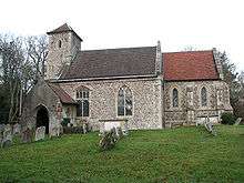
The church is dedicated to Saint Andrew, and dates back, at least in part, to the 12th century.[1] It holds a plain Norman font and a painted wooden effigy of Robert du Bois.[2]
RAF Fersfield
RAF Fersfield is a former World War II airfield located between Fersfield and Winfarthing which was closed after the war and briefly used as a motor racing track before being returned to agricultural use.
Notes
- Blomefield, Francis (c. 1736). . . 1. London (published c. 1806).
- Knott, Simon (March 2005). "St Andrew, Fersfield". The Norfolk Churches Site.