Felt, Oklahoma
Felt is a small unincorporated community and census-designated place (CDP) in Cimarron County, Oklahoma, United States. As of the 2010 census it had a population of 93.[1] It was named for C.F.W. Felt of the Santa Fe Railroad. Nearby is the Cedar Breaks Archeological District. The community is served by a post office (established July 16, 1926) and a school.
Felt, Oklahoma | |
|---|---|
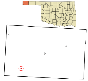 Location in Cimarron County and state of Oklahoma | |
| Coordinates: 36°34′3″N 102°47′37″W | |
| Country | United States |
| State | Oklahoma |
| County | Cimarron |
| Area | |
| • Total | 0.53 sq mi (1.36 km2) |
| • Land | 0.53 sq mi (1.36 km2) |
| • Water | 0.0 sq mi (0.0 km2) |
| Elevation | 4,450 ft (1,360 m) |
| Population (2010) | |
| • Total | 93 |
| • Density | 177/sq mi (68.3/km2) |
| Time zone | UTC-6 (Central (CST)) |
| • Summer (DST) | UTC-5 (CDT) |
| ZIP code | 73937 |
| FIPS code | 40-25850 |
Geography
Felt is located in southwestern Cimarron County, near the western end of the Oklahoma Panhandle. U.S. Routes 56, 64, and 412 pass through the community, leading northeast 20 miles (32 km) to Boise City, the Cimarron County seat, and southwest 24 miles (39 km) to Clayton, New Mexico.
References
- "Geographic Identifiers: 2010 Demographic Profile Data (G001): Felt CDP, Oklahoma". U.S. Census Bureau, American Factfinder. Archived from the original on February 20, 2015. Retrieved February 20, 2015.
Municipalities and communities of Cimarron County, Oklahoma, United States | ||
|---|---|---|
| City | 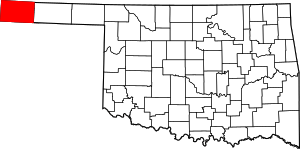 Map of Oklahoma highlighting Cimarron County | |
| Town | ||
| CDPs | ||
| Other unincorporated communities | ||
| Authority control |
|
|---|
This article is issued from Wikipedia. The text is licensed under Creative Commons - Attribution - Sharealike. Additional terms may apply for the media files.