Farm to Market Road 2101
Farm to Market Road 2101 (FM 2101) is a highway located in Hunt County, Texas.[1]
| ||||
|---|---|---|---|---|
| ||||
| Route information | ||||
| Maintained by TxDOT | ||||
| Length | 14.246 mi[1] (22.927 km) | |||
| Existed | 1953–present | |||
| Major junctions | ||||
| South end | ||||
| North end | ||||
| Location | ||||
| Counties | Hunt | |||
| Highway system | ||||
| ||||

Route description
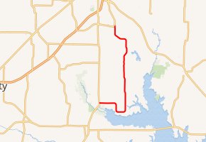
The southern terminus of FM 2101 is at SH 34 northeast of Quinlan.[2] From this location, the roadway travels to the east and briefly dips southward toward Lake Tawakoni before turning northward, roughly paralleling SH 34 for its entire length.[3] The route enters the city of Greenville and ends at FM 1570 at the western edge of Majors Airport.
Though the road primarily serves local residential and agricultural traffic, FM 2101 also serves commuters bound for a large L-3 Communications facility at Majors Airport.
History
The southern section of FM 2101 was designated on October 28, 1953, and ran approximately 4.0 miles (6.4 km) from SH 34 along the northern shore of Lake Tawakoni. The route was extended northward, first to FM 1564 on September 27, 1960 and then to the current northern terminus at FM 1570 on May 7, 1970.[1]
Major intersections
The entire route is in Hunt County.
| Location | mi[4] | km | Destinations | Notes | |
|---|---|---|---|---|---|
| | 0.0 | 0.0 | Southern terminus | ||
| | 6.7 | 10.8 | |||
| | 9.3 | 15.0 | |||
| Greenville | 14.3 | 23.0 | Northern terminus | ||
| 1.000 mi = 1.609 km; 1.000 km = 0.621 mi | |||||
References
- Transportation Planning and Programming Division (n.d.). "Farm to Market Road No. 2101". Highway Designation Files. Texas Department of Transportation. Retrieved October 26, 2012.
- Transportation Planning and Programming Division (2012). Texas County Mapbook (PDF) (Map) (2012 ed.). 1:120,000. Texas Department of Transportation. p. 507. OCLC 867856197.
- Transportation Planning and Programming Division (2012). Texas County Mapbook (PDF) (Map) (2012 ed.). 1:120,000. Texas Department of Transportation. p. 529. OCLC 867856197.
- Google (October 26, 2012). "FM 2101 Overview Map with Major Intersections" (Map). Google Maps. Google. Retrieved October 26, 2012.