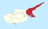
Famagusta District
Famagusta District is one of the six districts of Cyprus. Its main town is the island's most important port, Famagusta.
.svg.png)
A district administration in "exile" exists on the Republic of Cyprus-controlled part of the island. This part of the district has a population of 46,900 inhabitants (2015).[1]
Most of the district has been under Turkish control since the 1974 invasion. Since then, the northeastern section, including the Karpaz Peninsula, has been administered separately as the İskele District, a division not recognized by the Republic of Cyprus and the UN.
Cape Greco (Italian: Capo Greco; Greek: Κάβο Γκρέκο, romanized: Kavo Greko; "Greek cape"), is a headland in the southeastern part of the district. It is at the southern end of Famagusta Bay. It is visited by tourists for its natural environment, and is a protected coastal nature park. From the high points on the cliff that rests at the cape one can view out to sea. According to local legend, it is also the home of the Ayia Napa sea monster.
Settlements
According to Statistical Codes of Municipalities, Communities and Quarters of Cyprus per the Statistical Service of Cyprus (2015), Famagusta District has 8 municipalities and 90 communities.[2] Municipalities are written with bold.
- Acheritou
- Achna
- Afania
- Agia Trias
- Agios Andronikos (Topçuköy)
- Agios Andronikos
- Agios Chariton
- Agios Efstathios
- Agios Georgios
- Agios Iakovos
- Agios Ilias
- Agios Nikolaos
- Agios Sergios
- Agios Symeon
- Agios Theodoros
- Akanthou
- Aloda
- Angastina
- Ardana
- Arnadi
- Artemi
- Asha
- Avgolida
- Avgorou
- Ayia Napa
- Bogazi
- Davlos
- Deryneia
- Enkomi
- Eptakomi
- Famagusta
- Flamoudi
- Frenaros
- Gaidouras
- Galateia
- Galinoporni
- Gastria
- Genagra
- Gerani
- Gialousa
- Goufes
- Gypsou
- Kalopsida
- Knodara
- Koilanemos
- Koma tou Gialou
- Komi Kebir
- Kontea
- Kornokipos
- Koroveia
- Kouklia
- Krideia
- Lapathos
- Lefkoniko
- Leonarisso
- Limnia
- Liopetri
- Livadia
- Lysi
- Lythrangomi
- Makrasyka
- Mandres
- Maratha
- Marathovounos
- Melanagra
- Melounta
- Milia
- Monarga
- Mousoulita
- Neta
- Ovgoros
- Paralimni
- Patriki
- Peristerona
- Perivolia
- Pigi
- Platani
- Platanissos
- Prastio
- Psyllatos
- Pyrga
- Rizokarpaso
- Santalaris
- Sinta
- Sotira
- Spathariko
- Strongylos
- Stylloi
- Sygkrasi
- Tavros
- Trikomo
- Trypimeni
- Tziaos
- Vasili
- Vathylakas
- Vatili
- Vitsada
- Vokolida
References
- Statistical Service of the Republic of Cyprus (MS Excel), 2015 Population Estimate.
- "Statistical Codes of Municipalities, Communities and Quarters of Cyprus per the Statistical Service of Cyprus, 2015". Statistical Service of Cyprus. Archived from the original on 2018-08-04. Retrieved 2018-08-04.
External links
| Wikivoyage has a travel guide for Famagusta district. |