Falkville, Alabama
Falkville is a town in Morgan County, Alabama, United States and is included in the Huntsville-Decatur metropolitan areas. As of the 2010 census, the population of the town was 1,279, up from 1,202 in 2000.
Falkville, Alabama | |
|---|---|
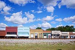 Railroad Street | |
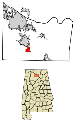 Location of Falkville in Morgan County, Alabama. | |
| Coordinates: 34°22′18″N 86°54′30″W | |
| Country | United States |
| State | Alabama |
| County | Morgan |
| Area | |
| • Total | 3.80 sq mi (9.83 km2) |
| • Land | 3.78 sq mi (9.79 km2) |
| • Water | 0.02 sq mi (0.05 km2) |
| Elevation | 600 ft (183 m) |
| Population (2010) | |
| • Total | 1,279 |
| • Estimate (2018)[2] | 1,248 |
| • Density | 330.25/sq mi (127.52/km2) |
| Time zone | UTC-6 (Central (CST)) |
| • Summer (DST) | UTC-5 (CDT) |
| ZIP code | 35622 |
| Area code(s) | 256 |
| FIPS code | 01-25648 |
| GNIS feature ID | 0118175 |
| Website | www |
Falkville incorporated three times: first in 1876, again on June 19, 1886, and lastly on December 13, 1898.[3]
History
Falkville was named for Louis M. Falk, a Prussian merchant who emigrated to the area in the late 1850s. Falk opened a general store in what is now Falkville in 1859,[4] and later became the town's first postmaster.[3] The L&N Railroad was constructed through Falkville in the early 1870s, and a rail station opened in 1872.[3]
In 1936, the Works Progress Administration constructed a town hall for Falkville. This building now serves as the town's library.[5]
Geography
Falkville is located at 34°22′19″N 86°54′30″W (34.371919, -86.908381).[6] The town is concentrated along U.S. Route 31 south of Hartselle. Interstate 65 passes through eastern part of town.
According to the U.S. Census Bureau, the town has a total area of 3.7 square miles (9.6 km2), all land.
Demographics
| Historical population | |||
|---|---|---|---|
| Census | Pop. | %± | |
| 1880 | 105 | — | |
| 1900 | 343 | — | |
| 1910 | 335 | −2.3% | |
| 1920 | 362 | 8.1% | |
| 1930 | 543 | 50.0% | |
| 1940 | 567 | 4.4% | |
| 1950 | 613 | 8.1% | |
| 1960 | 682 | 11.3% | |
| 1970 | 946 | 38.7% | |
| 1980 | 1,310 | 38.5% | |
| 1990 | 1,337 | 2.1% | |
| 2000 | 1,202 | −10.1% | |
| 2010 | 1,279 | 6.4% | |
| Est. 2018 | 1,248 | [2] | −2.4% |
| U.S. Decennial Census[7] 2013 Estimate[8] | |||
At the 2000 census there were 1,202 people, 365 households, and 254 families in the town. The population density was 326.3 people per square mile (126.1/km²). There were 390 housing units at an average density of 105.9 per square mile (40.9/km²). The racial makeup of the town was 92.26% White, 5.91% Black or African American, 0.67% Native American, 0.08% from other races, and 1.08% from two or more races. 0.42% of the population were Hispanic or Latino of any race.[9] Of the 365 households 27.9% had children under the age of 18 living with them, 55.6% were married couples living together, 10.4% had a female householder with no husband present, and 30.4% were non-families. 26.8% of households were one person and 12.6% were one person aged 65 or older. The average household size was 2.42 and the average family size was 2.94.
The age distribution was 16.6% under the age of 18, 8.7% from 18 to 24, 20.7% from 25 to 44, 21.0% from 45 to 64, and 32.9% 65 or older. The median age was 49 years. For every 100 females, there were 71.5 males. For every 100 females age 18 and over, there were 71.3 males.
The median household income was $34,583 and the median family income was $40,759. Males had a median income of $29,231 versus $23,365 for females. The per capita income for the town was $13,510. About 5.5% of families and 11.6% of the population were below the poverty line, including 7.9% of those under age 18 and 31.7% of those age 65 or over.
2010 census
At the 2010 census there were 1,279 people, 387 households, and 274 families in the town. The population density was 345.7 people per square mile (134.6/km²). There were 437 housing units at an average density of 118.1 per square mile (46/km²). The racial makeup of the town was 92.1% White, 3.4% Black or African American, 1.1% Native American, 1.3% from other races, and 1.8% from two or more races. 2.2% of the population were Hispanic or Latino of any race.[10] Of the 387 households 29.2% had children under the age of 18 living with them, 49.4% were married couples living together, 16.5% had a female householder with no husband present, and 29.2% were non-families. 25.6% of households were one person and 10.3% were one person aged 65 or older. The average household size was 2.51 and the average family size was 2.98.
The age distribution was 18.5% under the age of 18, 6.6% from 18 to 24, 21.4% from 25 to 44, 21.0% from 45 to 64, and 32.6% 65 or older. The median age was 48.1 years. For every 100 females, there were 68.7 males. For every 100 females age 18 and over, there were 90.9 males.
The median household income was $36,848 and the median family income was $44,150. Males had a median income of $35,450 versus $21,635 for females. The per capita income for the town was $16,850. About 7.9% of families and 11.5% of the population were below the poverty line, including 15.1% of those under age 18 and 24.8% of those age 65 or over.
Climate
The climate in this area is characterized by hot, humid summers and generally mild to cool winters. According to the Köppen Climate Classification system, Falkville has a humid subtropical climate, abbreviated "Cfa" on climate maps.[11]
Notable people
- Tom Drake, attorney, former professional wrestler, politician, and former member of the athletic staff of football coach Bear Bryant
- Roy Drinkard, businessman
- Heather Wilhite, businesswoman
- Rodney Jones, American poet
References
- "2018 U.S. Gazetteer Files". United States Census Bureau. Retrieved June 4, 2019.
- "Population and Housing Unit Estimates". Retrieved June 4, 2019.
- Christopher Maloney, "Falkville," Encyclopedia of Alabama, 14 May 2013.
- History, Town of Falkville official site
- Alabama Tourism Department marker in Falkville, Alabama. Information accessed 16 September 2018.
- "US Gazetteer files: 2010, 2000, and 1990". United States Census Bureau. 2011-02-12. Retrieved 2011-04-23.
- "U.S. Decennial Census". Census.gov. Retrieved June 6, 2013.
- "Annual Estimates of the Resident Population: April 1, 2010 to July 1, 2013". Archived from the original on May 22, 2014. Retrieved June 3, 2014.
- "U.S. Census website". United States Census Bureau. Retrieved 2008-01-31.
- "U.S. Census website". United States Census Bureau. Retrieved 2015-08-05.
- Climate Summary for Falkville, Alabama
External links

Municipalities and communities of Morgan County, Alabama, United States | ||
|---|---|---|
| Cities |  Map of Alabama highlighting Morgan County | |
| Towns | ||
| Unincorporated communities | ||
| Ghost town | ||
| Former City | ||
| Former Town | ||
| Footnotes | ‡This populated place also has portions in an adjacent county or counties | |
| Authority control |
|
|---|