Faistos
Faistos (Greek: Φαιστός) is a municipality in Heraklion regional unit, Crete, Greece. The seat of the municipality is the village Moires.[2] It is named after the ancient city Phaistos, located in the municipality. The municipality has an area of 410.810 km2 (158.615 sq mi).[3]
Faistos Φαιστός | |
|---|---|
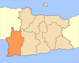 | |
 Faistos Location within the region  | |
| Coordinates: 35°03′N 24°52′E | |
| Country | Greece |
| Administrative region | Crete |
| Regional unit | Heraklion |
| Area | |
| • Municipality | 410.8 km2 (158.6 sq mi) |
| Population (2011)[1] | |
| • Municipality | 24,466 |
| • Municipality density | 60/km2 (150/sq mi) |
| Time zone | UTC+2 (EET) |
| • Summer (DST) | UTC+3 (EEST) |
Municipality
The municipality Faistos was formed at the 2011 local government reform by the merger of the following 3 former municipalities, that became municipal units:[2]
Geography
Climate
| Climate data for Faistos, Greece | |||||||||||||
|---|---|---|---|---|---|---|---|---|---|---|---|---|---|
| Month | Jan | Feb | Mar | Apr | May | Jun | Jul | Aug | Sep | Oct | Nov | Dec | Year |
| Average high °F (°C) | 59.0 (15.0) |
59.1 (15.1) |
61.7 (16.5) |
68.0 (20.0) |
74.1 (23.4) |
80.8 (27.1) |
83.3 (28.5) |
82.8 (28.2) |
79.5 (26.4) |
74.1 (23.4) |
67.3 (19.6) |
61.9 (16.6) |
71.0 (21.7) |
| Average low °F (°C) | 48.4 (9.1) |
48.2 (9.0) |
49.3 (9.6) |
53.8 (12.1) |
59.5 (15.3) |
66.6 (19.2) |
71.4 (21.9) |
71.6 (22.0) |
67.3 (19.6) |
62.1 (16.7) |
56.1 (13.4) |
51.3 (10.7) |
58.8 (14.9) |
Source: <Yr.no >Weather statistics for Phaistos, Crete (Greece). Yr.no. 2016 http://www.yr.no/place/Greece/Crete/Phaistos~262531/statistics.html. Retrieved 13 September 2016. Missing or empty |title= (help) | |||||||||||||
References
- "Απογραφή Πληθυσμού - Κατοικιών 2011. ΜΟΝΙΜΟΣ Πληθυσμός" (in Greek). Hellenic Statistical Authority.
- Kallikratis law Greece Ministry of Interior (in Greek)
- "Population & housing census 2001 (incl. area and average elevation)" (PDF) (in Greek). National Statistical Service of Greece. Archived from the original (PDF) on 2015-09-21.
Administrative division of the Crete Region | ||
|---|---|---|
| Regional unit of Chania | 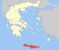 | |
| Regional unit of Heraklion | ||
| Regional unit of Lasithi |
| |
| Regional unit of Rethymno | ||
| ||
| Authority control |
|
|---|
This article is issued from Wikipedia. The text is licensed under Creative Commons - Attribution - Sharealike. Additional terms may apply for the media files.