Fairview, Kenton County, Kentucky
Fairview is a home rule-class city in Kenton County, Kentucky, in the United States. It was incorporated by the state assembly in 1957.[2] The population was 143 at the 2010 census.[3]
Fairview, Kenton County, Kentucky | |
|---|---|
City | |
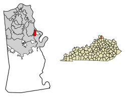 Location in Kenton County, Kentucky | |
 Fairview Location in Kentucky and United States  Fairview Fairview (the United States) | |
| Coordinates: 38°59′52″N 84°29′20″W | |
| Country | United States |
| State | Kentucky |
| County | Kenton |
| Area | |
| • Total | 0.74 sq mi (1.91 km2) |
| • Land | 0.73 sq mi (1.89 km2) |
| • Water | 0.008 sq mi (0.02 km2) |
| Elevation | 530 ft (160 m) |
| Population (2010) | |
| • Total | 143 |
| • Estimate (2016)[1] | 145 |
| • Density | 196/sq mi (75.5/km2) |
| Time zone | UTC-5 (Eastern (EST)) |
| • Summer (DST) | UTC-4 (EDT) |
| ZIP code | 41015 |
| Area code(s) | 859 |
| FIPS code | 21-26236 |
| Website | fairview |
Geography
Fairview is located in eastern Kenton County at 38°59′52″N 84°29′20″W (38.997862, -84.488770).[4] It is bordered to the north and west by Taylor Mill, to the east by unincorporated land, to the southeast by Ryland Heights, and to the southwest by Covington. The city lies in the valley of DeCoursey Creek, a north-flowing tributary of the Licking River, which in turn flows north to the Ohio River.
Kentucky Route 177 runs through Fairview, leading north 6 miles (10 km) to the center of Covington and south 3.5 miles (5.6 km) to Ryland Heights.
According to the United States Census Bureau, the city of Fairview has a total area of 0.73 square miles (1.9 km2), of which 0.01 square miles (0.02 km2), or 0.89%, are water.[3]
Demographics
| Historical population | |||
|---|---|---|---|
| Census | Pop. | %± | |
| 1960 | 368 | — | |
| 1970 | 235 | −36.1% | |
| 1980 | 198 | −15.7% | |
| 1990 | 119 | −39.9% | |
| 2000 | 156 | 31.1% | |
| 2010 | 143 | −8.3% | |
| Est. 2016 | 145 | [1] | 1.4% |
| U.S. Decennial Census[5] | |||
As of the census[6] of 2000, there were 156 people, 60 households, and 48 families residing in the city. The population density was 212.3 people per square mile (82.5/km²). There were 62 housing units at an average density of 84.4 per square mile (32.8/km²). The racial makeup of the city was 98.08% White, 0.64% Asian, 0.64% from other races, and 0.64% from two or more races. Hispanic or Latino of any race were 1.28% of the population.
There were 60 households out of which 30.0% had children under the age of 18 living with them, 65.0% were married couples living together, 8.3% had a female householder with no husband present, and 20.0% were non-families. 15.0% of all households were made up of individuals and 8.3% had someone living alone who was 65 years of age or older. The average household size was 2.60 and the average family size was 2.92.
In the city, the population was spread out with 17.9% under the age of 18, 6.4% from 18 to 24, 32.1% from 25 to 44, 26.9% from 45 to 64, and 16.7% who were 65 years of age or older. The median age was 41 years. For every 100 females, there were 108.0 males. For every 100 females age 18 and over, there were 113.3 males.
The median income for a household in the city was $55,417, and the median income for a family was $55,417. Males had a median income of $32,917 versus $32,917 for females. The per capita income for the city was $20,737. None of the population or families were below the poverty line.
References
- "Population and Housing Unit Estimates". Retrieved June 9, 2017.
- Commonwealth of Kentucky. Office of the Secretary of State. Land Office. "Fairview, Kentucky". Accessed 26 July 2013.
- "Geographic Identifiers: 2010 Demographic Profile Data (G001): Fairview city, Kentucky". American Factfinder. U.S. Census Bureau. Retrieved March 4, 2019.
- "US Gazetteer files: 2010, 2000, and 1990". United States Census Bureau. 2011-02-12. Retrieved 2011-04-23.
- "Census of Population and Housing". Census.gov. Retrieved June 4, 2015.
- "U.S. Census website". United States Census Bureau. Retrieved 2008-01-31.
External links
Municipalities and communities of Kenton County, Kentucky, United States | ||
|---|---|---|
| Cities | 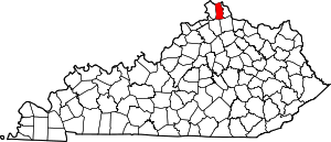 Location of Kenton County, Kentucky | |
| Unincorporated communities | ||
| Footnotes | ‡This populated place also has portions in an adjacent county or counties. | |