Føresvik
Føresvik (sometimes called Bokn) is the administrative centre of Bokn municipality in Rogaland county, Norway. The village is located on the northeastern shore of the island of Vestre Bokn, along the rather narrow Boknasundet strait which separates Vestre Bokn from the island of Austre Bokn. The European route E39 highway runs through the village and the bridge connecting Vestre Bokn to Austre Bokn (and ultimately to the mainland) is also located in Føresvik.[3]
Føresvik Bokn | |
|---|---|
Village | |
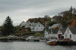 View of the village | |
 Føresvik Location in Rogaland county  Føresvik Føresvik (Norway) | |
| Coordinates: 59°13′51″N 05°26′21″E | |
| Country | Norway |
| Region | Western Norway |
| County | Rogaland |
| District | Haugaland |
| Municipality | Bokn |
| Area | |
| • Total | 0.31 km2 (0.12 sq mi) |
| Elevation | 3 m (10 ft) |
| Population (2014)[1] | |
| • Total | 279 |
| • Density | 900/km2 (2,000/sq mi) |
| Time zone | UTC+01:00 (CET) |
| • Summer (DST) | UTC+02:00 (CEST) |
| Post Code | 5561 Bokn |
The village is the main urban area for the whole municipality, and it includes the local government offices, school, commercial centre, and Bokn Church. The 0.31-square-kilometre (77-acre) village has a population (2014) of 279, giving the village a population density of 900 inhabitants per square kilometre (2,300/sq mi). The village is referred to as the village of Bokn by Statistics Norway.[1][3]
References
- Statistisk sentralbyrå (1 January 2014). "Urban settlements. Population and area, by municipality".
- "Føresvik, Bokn (Rogaland)" (in Norwegian). yr.no. Retrieved 2015-10-27.
- Store norske leksikon. "Føresvik" (in Norwegian). Retrieved 2015-10-27.