Etna Township, Licking County, Ohio
Etna Township is one of the twenty-five townships of Licking County, Ohio, United States. The 2010 census found 16,373 people in the township, 8,311 of whom lived in the unincorporated portions of the township.[4]
Etna Township, Licking County, Ohio | |
|---|---|
 Township hall at Etna | |
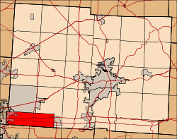 Location of Etna Township in Licking County | |
| Coordinates: 39°57′14″N 82°41′37″W | |
| Country | United States |
| State | Ohio |
| County | Licking |
| Area | |
| • Total | 23.4 sq mi (61 km2) |
| • Land | 23.3 sq mi (60 km2) |
| • Water | 0.1 sq mi (0.3 km2) |
| Elevation | 1,070 ft (326 m) |
| Population (2010) | |
| • Total | 16,373 |
| • Density | 700/sq mi (270/km2) |
| Time zone | UTC-5 (Eastern (EST)) |
| • Summer (DST) | UTC-4 (EDT) |
| ZIP code | 43018, 43062 |
| Area code(s) | 740 |
| FIPS code | 39-25690[3] |
| GNIS feature ID | 1086456[2] |
Geography
Located in the southwestern corner of the county, it borders the following townships and city:
- Pataskala - north
- Harrison Township - northeast
- Liberty Township, Fairfield County - southeast
- Violet Township, Fairfield County - southwest
- Truro Township, Franklin County - west
- Jefferson Township, Franklin County - northwest corner
Part of the city of Reynoldsburg occupies the western end of Etna Township, part of the village of Kirkersville occupies the eastern end, and the unincorporated community of Etna lies in the central part of the township.
Name and history
Etna Township was established in 1833.[5] It is the only Etna Township statewide.[6]
Two Native American mounds, known as the "Etna Township Mounds", are located within the township.[7] Etna Township is located entirely within the Refugee Tract.
Government
The township is governed by a three-member board of trustees, who are elected in November of odd-numbered years to a four-year term beginning on the following January 1. Two are elected in the year after the presidential election and one is elected in the year before it. There is also an elected township fiscal officer,[8] who serves a four-year term beginning on April 1 of the year after the election, which is held in November of the year before the presidential election. Vacancies in the fiscal officership or on the board of trustees are filled by the remaining trustees.
References
- "2010 Census U.S. Gazetteer Files for County Subdivisions". U.S. Census Bureau, Geography Division. 2 February 2011. Archived from the original on 9 April 2011. Retrieved 18 February 2012.
- "US Board on Geographic Names". United States Geological Survey. 2007-10-25. Retrieved 2008-01-31.
- "U.S. Census website". United States Census Bureau. Retrieved 2008-01-31.
- "Population and Household Counts for Governmental Units: 2010, 2000, 1990" (PDF). Ohio Department of Development. August 2011. Archived from the original (PDF) on 27 October 2016. Retrieved 18 February 2012.
- Overman, William Daniel (1958). Ohio Town Names. Akron, OH: Atlantic Press. p. 43.
- "Detailed map of Ohio" (PDF). United States Census Bureau. 2000. Retrieved 2007-02-16.
- "National Register Information System". National Register of Historic Places. National Park Service. March 13, 2009.
- §503.24, §505.01, and §507.01 of the Ohio Revised Code. Accessed 4/30/2009.
External links
Municipalities and communities of Licking County, Ohio, United States | ||
|---|---|---|
| Cities | 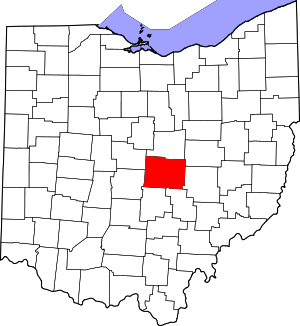 Map of Ohio highlighting Licking County | |
| Villages | ||
| Townships | ||
| CDPs | ||
| Unincorporated communities | ||
| Ghost towns | ||
| Footnotes | ‡This populated place also has portions in an adjacent county or counties | |