Etah
Etah is a municipality town which is also the district headquarters of Etah district of Uttar Pradesh state, India.Etah is a district of Uttar Pradesh since 1854.The driving distance from New Delhi to Etah is 206 km and Lucknow to Etah is 267Km.And it takes approximately 6 hours by public transport to reach there. There is a famous village Malawan .Tulsidas was also born in Etah District.[1][2][3] It is 82 kilometers from Agra, which is Two hour by road.[4] Etah District is part of the Aligarh Division.Tourism Place Awagarh Fort .
Block list of Etah District
Etah Tehsil-etah
- Block -Shitalpur-02/10/1956
- Block-Sakit-01/04/1958
- Block-Nidhoulikalan-01/04/1959
- Block-Marhera-01/04/1960
Tehsil-Aliganj
- Block-Aliganj-01/04/1953
- Block-Jaithra-01/04/1960
Tehsil-Jalesar
- Block-Jalesar-01/04/1957
- Block-Awagarh-26/01/1956
Etah | |
|---|---|
City | |
 Etah Location in Uttar Pradesh, India | |
| Coordinates: 27.63°N 78.67°E | |
| Country | |
| State | Uttar Pradesh |
| District | Etah |
| Founded by | King Dil Sukh Rai Bahadur |
| Government | |
| • Etah (Lok Sabha constituency )MP | Rajveer Singh (BJP) |
| Population (2011) | |
| • Total | 131,023 |
| Languages | |
| • Official | Hindi |
| Time zone | UTC+5:30 (IST) |
| Vehicle registration | UP-82 |
| Website | http://etah.nic.in/ |
Geography
Etah is located at 27.63°N 78.67°E.[5] It has an average elevation of 170 metres (557 feet). Eesan river flows through there (though very polluted now and almost dried up) behind the village Gajipur Pahore.
History
Etah was an early seat of an Aryan civilization, and the surrounding country is mentioned by Xuanzang, the Chinese Buddhist pilgrim of the 7th century, as rich in temples and monasteries. But after the repression of Buddhism before the 8th century, and an intermediate period of tribalism, it was controlled by Yadavs during the course of their migration eastward. With the rest of upper India it passed under the sway of Mahmud of Ghazni in 1017, and thenceforth followed the fortunes of the Muslim empire. At the end of the 18th century it formed part of the territory over which Wazir Ali Khan had made himself ruler, and passed to the British Raj in 1801, under the treaty of Lucknow.[6]
Agriculture
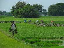
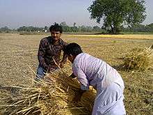
The primary occupation of the people of the district is agriculture. The area is situated between Ganga and Yamuna (Doaab) which is highly fertile (Alluvial soil). The farmers are harvesting three crops in a year. The water for irrigation is available the year round. Major agricultural products are rice, wheat, barley, jowar, bajra, maize; the soil is suitable for the cultivation of tobacco.
Population density
The initial provisional data released by census India 2011, shows that density of Etah district for 2011 is 717 people per km2. In 2001, Etah district density was at 636 people per km2. Etah district administers 2,456 square kilometers of areas.
Cultural

Etah is a developing city. It is the district headquarters since the British times. National Highway 91 (India)(NH 91) GT Road passes through city Etah. The Padav maidan (open field) is the field used for the army during army movements. Every year this field is used for Ram-Lila at Dussehra in month September and October and for exhibitions in month from December to February.
Demographics
As per provisional data of 2011 census, Etah urban agglomeration had a population of 131,023, out of which males were 69,446 and females were 61,577. The literacy rate was 85.62 per cent.[7]
As of 2001 India census,[8] Etah has a population of 107,098. Males constitute 53% of the population and females 47%. Etah has an average literacy rate of 68%, higher than the national average of 59.5%: male literacy is 73%, and female literacy is 63%. In Etah, 14% of the population is under 6 years of age.
Developments
The opening of railway line by the first president Rajendra Prasad. Here is only one small railway line from ETAH to Tundla and further railway connectivity to Kasganj and Aligarh is on high demand by people of Etah. Etah get first Etah-Agra fort Pass train for Six month as a trail. Now District get Etah-Kasganj,Etah-Malawan new rail network. Etah will be a Junction in future.
Railway Ministry has approved the survey for direct trains to New Delhi, Agra and Aligarh.
A thermal power project of 1320 MW has been proposed Situated at Malawan.and approximately 15 km from Etah, Ministry of Environment has cleared the project. Land acquisition work is over and construction of the same shall complete in 2021. A new firing range is built in Etah on Nidhauli road.Now Etah is a developing city.There are running many Gov. Scheme.like Etah-Aligarh Bypass (NH91), Jalesar-Bareilly Highway,Etah seaverage,Etah Medical College, Etc.
Religious places
Dargah Hazrat Makhdoom Abdul Ghafur Shah Safvi is situated at holi gate, hazrat was the Great Sufi of the "silsila e chishtiya and safviya-khadimiya" and Haji Mohammad Islam Safvi is the sajjada nashin of dargah sharif at present time
The Kailash Mandir at Etah was built by King Dil Sukh Rai Bahadur and is 148 years old.
Noah Kera village was known for marriage of Lord Sri Krishna with Rukmini.
Bhooteshwar is a place for Hindu bodies to be cremated.
Food
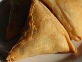
Etah food consists of the food prepared in the state of Uttar Pradesh, India. It consists of the Mughlai near in Agra cuisines and comprises vegetarian and non-vegetarian foods. Dum biryani, kababs, and kormas are some of the dishes made in this region.
 Assorted halva including sooji, chana, and gajar halva
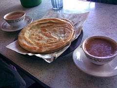 Paratha served with tea
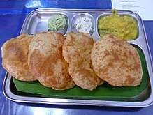 Puri with accompaniments
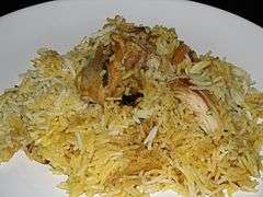 Chicken Dum Biryani
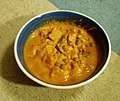 Navratan korma
 Chicken curry with chapati
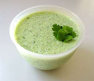
Education
Etah has educational institutes which include: Saraswati vidhya mandir, St Paul's Sr sec school, Assisi convent school(Sr+Jr), Limra International school, B.S.D. Public School, BPS Public School(ICSE & ISC), Kendriya Vidyalaya, Jawahar Navodaya Vidyalaya, Gyan Bharti Inter College, Tulip Public School, Sri Ram Bal Bharati Higher Secondary School, Dr. Lokman Das Public School, Apex Public School, S.B Public School, Christian Agricultural Inter College, G.I.C Inter College ( Government Inter College, Etah has been among prestigious schools in UP. It completed 100 years since establishment in 1914. It has the distinction of producing some of the best administrators, Vice Chancellors, Other Educationists, Military personnel, Doctors, Industrialists and Engineers among many others ) , Avinash Sahay Arya Inter college, Gandhi smarak college, JLN College, Printis Girls College, G.G.I.C. Inter College, Government Polytechnic college, Government I.T.I and Lakshmi Bai Inter College, Sri Bhumi Raj Singh Leela Devi Mahavidyalaya Larampur Aliganj Etah, Ganjdundwara PG College, Dr. Z.H. Degree College and Jawaharlal Nehru Degree College Etah,Shri Bhole Nath Ji Public School Etah, S.K. Degree College Etah
References
- Distance between Etah, Uttar Pradesh and New Delhi, Delhi 128 Miles / 206km. Distancebetweencities.co.in. Retrieved on 2014-01-02.
- Fifth phase of UP polls to seal Yadavs' fate. Hindustan Times (2012-02-22). Retrieved on 2014-01-02.
- Sherring, Matthew Atmore (1872). Hindu Tribes and Castes. Thacker, Spink & Company. p. 237.
Ahirs.
- Distancebetween.co. Retrieved on 2018-04-07.
- Falling Rain Genomics, Inc – Etah. Fallingrain.com. Retrieved on 2014-01-02.
-

- "Urban Agglomerations/Cities having population 1 lakh and above" (PDF). Provisional Population Totals, Census of India 2011. Retrieved 7 July 2012.
- "Census of India 2001: Data from the 2001 Census, including cities, villages and towns (Provisional)". Census Commission of India. Archived from the original on 16 June 2004. Retrieved 1 November 2008.