Erin (CDP), New York
Erin is a hamlet and census-designated place in the town of Erin in Chemung County, New York, United States. The population of the CDP was 483 at the 2010 census,[2] out of a total town population of 1,962.
Erin, New York | |
|---|---|
 Erin Location within the state of New York | |
| Coordinates: 42°11′09″N 76°40′11″W[1] | |
| Country | United States |
| State | New York |
| County | Chemung County |
| Town | Erin |
| Area | |
| • Total | 0.76 sq mi (1.96 km2) |
| • Land | 0.75 sq mi (1.94 km2) |
| • Water | 0.008 sq mi (0.02 km2) |
| Elevation | 1,265 ft (386 m) |
| Population | |
| • Total | 483 |
| • Density | 646/sq mi (249.5/km2) |
| Time zone | UTC-5 (Eastern (EST)) |
| • Summer (DST) | UTC-4 (EDT) |
| ZIP code | 14838 |
| Area code | 607 |
| FIPS code | 36-24625 |
| GNIS feature ID | 944682 |
Geography
Erin is located in northeastern Chemung County in the center of the town of Erin. It is in the valley of Newtown Creek, a west-flowing (and later south-flowing) tributary of the Chemung River, which in turn is a tributary of the Susquehanna River. New York State Route 223 passes through the center of Erin, leading west 3.5 miles (5.6 km) to Breesport and 7 miles (11 km) to NY-13 near the village of Horseheads. Route 223 leads northeast 5.7 miles (9.2 km) to NY-224 in the valley of Cayuta Creek, which then leads 2.5 miles (4.0 km) farther east to Van Etten.
According to the United States Census Bureau, Erin has a total area of 0.76 square miles (1.96 km2), of which 0.75 square miles (1.94 km2) is land and 0.008 square miles (0.02 km2), or 1.26%, is water.[2]
References
- "Erin". Geographic Names Information System. United States Geological Survey.
- "Geographic Identifiers: 2010 Demographic Profile Data (G001): Erin CDP, New York". U.S. Census Bureau, American Factfinder. Archived from the original on February 12, 2020. Retrieved November 4, 2014.
Municipalities and communities of Chemung County, New York, United States | ||
|---|---|---|
| City | 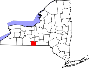 | |
| Towns | ||
| Villages | ||
| CDPs | ||
| Hamlets | ||