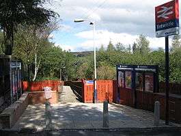
Entwistle railway station
The rural Entwistle railway station first opened in 1848 is 5 3⁄4 miles (9.3 km) north of Bolton and serves the village of Entwistle. It is also the closest station to Edgworth. Unlike nearby Bromley Cross the station lies outside the Transport for Greater Manchester boundary, meaning that passengers cannot take advantage of their special offers and ticketing. Owing to the remote location and low passenger numbers, Entwistle has been a request stop for several years. It is served by Northern services on the Manchester Victoria/Bolton 'Ribble Valley' Line towards Blackburn and Clitheroe in England.
| Entwistle | |
|---|---|
 | |
| Location | |
| Place | Entwistle |
| Local authority | Blackburn with Darwen |
| Coordinates | 53.656°N 2.415°W |
| Grid reference | SD727177 |
| Operations | |
| Station code | ENT |
| Managed by | Northern Trains |
| Number of platforms | 1 |
| DfT category | F2 |
| Live arrivals/departures, station information and onward connections from National Rail Enquiries | |
| Annual rail passenger usage* | |
| 2014/15 | |
| 2015/16 | |
| 2016/17 | |
| 2017/18 | |
| 2018/19 | |
| History | |
| Original company | Bolton, Blackburn, Clitheroe and West Yorkshire Railway |
| Pre-grouping | Lancashire and Yorkshire Railway |
| Post-grouping | London Midland and Scottish Railway |
| 1 August 1848 | Opened[1] |
| National Rail – UK railway stations | |
| |
History
The original station opened in August 1848, being relocated from Whittlestone Head station to the north.[2] A more substantial stone building was built in 1859, as part of a larger contract, with similar stations being erected along the branch at The Oaks, Bromley Cross and Turton, by Manchester firm Joseph Greenup and Co. Demolition took place around the mid-1970s, several years after the station closed. The station exhibited a large outside wall platform clock. The 1859 contract was for both a station building and staff 'cottage' as erected at other stations along the branch.[3] The station building was actually more extended than the buildings seen at the other stations, with private dwelling accommodation included for the station master. The 1871 Census of Population revealed that resident at Entwistle Station was SM William Davies, 24, his wife Ann, 23 and infant daughter Mary, 1, plus two family visitors, one being the railway telegraph clerk at Clitheroe.[4] By the early 1900s, new accommodation was built for railway workers with the new railway terrace of cottages located on Overshores road, the lane beyond The Strawbury Duck Inn. The 1891 O.S. map survey[5] revealed that only two immediately nearby cottages existed - The Strawbury Duck Inn (then called Bridge House) and also a divided cottage alongside, Bridge Cottages.Bridge house became the Station Hotel before its current identity in the late 60's/early 70's as the Strawbury Duck. Entwistle served the Black Hill brickworks and Know Mill, sited where the smaller section of Wayoh reservoir occupies. Until recently the remains of an overhead cable railway, connecting the factory to the railway goods yard, were visible in an adjoining woods. The foundation bases for the supports are still visible in at least two locations. The mills were demolished when the level of the Wayoh Reservoir was raised and the station was reduced in size following the Beeching report of 1963 and the singling of the Bromley Cross to Blackburn section of the line a decade later. Entwistle goods yard closed in November 1959. One surviving historical feature alongside the station access path and close to the entrance gate, is the carved 'LYR' boundary marker stone, one of several that remain in place in the section between Bromley Cross and Entwistle. Entwistle had traditional 'York' platform over-sized flag stones. In late Autumn 2019, the platform underwent the first major rebuilding works since the early 1900s re-development. A section of the flag stones is covered over with modern anti-slip rubberised boarding sheets, but the remainder, including the entire original platform structure was fully dug out down to base level and a new steel frame platform structure being built. The original 'York' giant flag stones there and also around nine four feet long grooved stone blocks (likely to have been part of the station building top drainage/ gutter channel and left behind after the station building was demolished in the early 1970s) are both swept away by the site works and now form part of a large spoil heap to the rear. There are shaped sandstone blocks lying around from when the building was knocked down in the early 1970s. Exposed at the base of the site of the platform are layers of red brick walling and the outline of an earlier platform. The current platform is being refurbished and extended to accommodate the longer trains planned by Northern as part of their Great North Rail Project, due to be completed during 2020. It is doubtful that the original York stone platform coping stones will be re-used and is more likely that modern concrete edging flags will be used with inbuilt tactile characteristics.
Signal Box
Typically for this branch line, a Yardley/Smith type 1 brick signal box opened here in 1876, situated on the Down side north of the station, containing an 18 lever Smith frame. This box was replaced in Jan 1904 by a new 60 lever, gantry-mounted size 12 L&YR box, in connection with the quadrupling of the line through to Waltons Siding 1453 yds to the north.[6] Numerous highly detailed large scale original drawings survive for these track and related works from the early 1900s[7] Included with the plans is a letter sent by the railway company secretary to The Board of Trade in April 1904 which discloses that 'the old station has been reconstructed. It now consists of an island platform 596 feet long.' It is also revealed that the station is on a gradient of 1 in 77. The authorisation for it was the L&YR Act of 1897. The signal box spanned the fast running lines and it is reported that it was a very draughty place of work, with its floorboards lifting like piano keys when a loco steaming hard passed underneath it. The box closed in 1968 when the through fast lines were taken out of use.
Media appearances
The station has been used as a location for filming on more than one occasion:
In the 1986 film adaptation of Jeffrey Archer's novel First Among Equals, the sequences at the fictional Redfern Station were filmed there.
In Episode 2 of Max and Paddy's Road to Nowhere, the station featured as "Middlewood station" (not to be confused with a real life station of the same name on the Buxton Line) due to its supposedly rural backwater location.
Services
The service has changed to more or less hourly throughout the week,[8] although it remains a request stop.
References
- Butt, R. V. J. (1995). The Directory of Railway Stations: details every public and private passenger station, halt, platform and stopping place, past and present (1st ed.). Sparkford: Patrick Stephens Ltd. p. 92. ISBN 978-1-85260-508-7. OCLC 60251199.
- Marshall, John (1969). The Lancashire & Yorkshire Railway, volume 1. Newton Abbot: David & Charles. p. 181. ISBN 0-7153-4352-1.CS1 maint: ref=harv (link)
- original railway co minutes held at National Archives, Kew on RAIL 52/4
- microfilm sheet RG10/3930, 1871 Census of Population, Lancashire CC Record Office
- Lancashire Sheet 10, survey date 1891, pub. 1893
- Littleworth, Chris (2002). Signal Boxes on Lancashire & Yorkshire Railway Lines: North-East Lancashire. Signalling Record Society. ISBN 1-873228-21-X.
- L&YR Entwistle - widening of line (7 plans), 1904, at ref A19/4/22. (with other plans available) Greater Manchester County Record Office, Central Library
- GB eNRT December 2105 Edition, Table 94
External links
| Wikimedia Commons has media related to Entwistle railway station. |
- Train times and station information for Entwistle railway station from National Rail
| Preceding station | Following station | |||
|---|---|---|---|---|
| Darwen | Northern Trains Ribble Valley Line |
Bromley Cross | ||
| Historical railways | ||||
| Spring Vale | L&YR Bolton, Blackburn, Clitheroe and West Yorkshire Railway |
Turton and Edgworth | ||