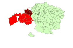
Enkarterri
Enkarterri (Spanish: Las Encartaciones) is a region of the province of Biscay, in the Basque Country, Spain. It is one of the seven eskualdeak/comarcas or districts that make up the province of Biscay. Its administrative centre is Balmaseda. Enkarterri stretches from the river Nervion and the Estuary of Bilbao in the east to the mountains that form its southern border with Cantabria and Castile-Leon in the west and south.
Enkarterri | |
|---|---|
 Coat of arms | |
 | |
| Country | Spain |
| Autonomous community | Basque Country |
| Province | Biscay |
| Municipalities | |
| Demonym(s) | encartados |
| Time zone | UTC+1 (CET) |
| • Summer (DST) | UTC+2 (CEST) |
Nowadays the name is most commonly used to refer to the rural part of the historical territory, while the urban area is known as the Left Bank (Margen Izquierda, Ezkerraldea) of the estuary, together with Barakaldo, that used to belong to Uribe.
Geography
Enkarterri is located at the northwest of the province of Biscay. It borders the community of Cantabria to the west, and the Province of Burgos (Castile and León) and the province of Álava, also in the Basque Country, to the south. The river Kadagua crosses the region and drains most of it.
Municipalities
| # | Municipality | Area km² |
Population | % of Population |
|---|---|---|---|---|
| Balmaseda | 22.3 | 7,168 | 20.15 | |
| Karrantza | 137.70 | 2,836 | 9.16 | |
| Artzentales | 36 | 692 | 2.23 | |
| Gueñes | 41.49 | 8,176 | 25.44 | |
| Zalla | 31.03 | 8,183 | 26.30 | |
| Sopuerta | 42.80 | 2,439 | 7.88 | |
| Galdames | 44.50 | 841 | 2.72 | |
| Gordexola | 41.50 | 1,658 | 5.35 | |
| Trucios-Turtzioz | 31 | 556 | 1.80 | |
| Lanestosa | 1.20 | 305 | 0.98 | |
| Enkarterri | 429,52 | 32,713 | 100.00 |