El Imposible National Park
El Imposible National Park (Spanish: Parque Nacional El Imposible) is a tropical forest and a national park in El Salvador. It was established on 1 January 1989 and covers an area of 38.20 square kilometres. It literally means "The Impossible National Park" in English. It has an altitude of between 250 and 1,425 metres.[1] El Imposible was named for the perilous gorge which used to claim the lives of farmers and pack mules transporting coffee to the Pacific port. El Imposible sits in the Apaneca Ilamatepec Mountain Range between 300m and 1450m above sea level, and includes eight rivers which feed the watershed for Barra de Santiago and the mangrove forests along the coast.
| El Imposible National Park | |
|---|---|
IUCN category II (national park) | |
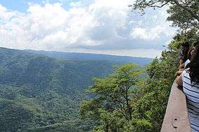 Lookout in the national park | |
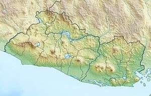 Location of El Imposible in El Salvador | |
| Location | Ahuachapán Department, El Salvador |
| Coordinates | 13°50′30″N 89°57′27″W[1] |
| Area | 38.20 km2 (14.75 sq mi)[1] |
| Established | 1 January 1989[1] |
The park is still home to an extraordinary variety of plant and animal life, including pumas, oncilla, wild boars, king hawks and black-crested eagles. The Pacific Ocean is visible from high points in the forest.[2]
In 1992 El Imposible was entered on the UNESCO World Heritage Tentative Lists, together with the Cara Sucia.[3]
References
- "El Salvador - El Imposible". United Nations Environment Programme. Retrieved 23 February 2010.
- http://www.lonelyplanet.com/el-salvador/western-el-salvador/parque-nacional-el-imposible
- "Cara Sucia / El Imposible". UNESCO. Retrieved 23 February 2010.
External links
| Authority control |
|
|---|