Ein Feshkha
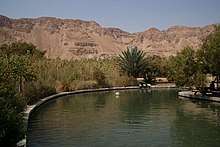
Ein Feshkha (Arabic: عين فشخة; Hebrew: עינות צוקים, Einot Tzukim; lit. "Cliff springs") is a nature reserve and archaeological site on the northwestern shore of the Dead Sea, about three kilometers south of Qumran in the West Bank.[1] Within the reserve is a group of springs of brackish water.[2] The nature reserve consists of an open section with pools of mineral water for bathing surrounded by high foliage and a section that is closed to visitors to protect the native flora and fauna.[3]
Location
’Ain el Feshkhah, (meaning "the spring of el Feshkhah", Feshkhah is a either personal name, or a word with no meaning[4]) is located just north of the headland Râs Feshkhah, (meaning: "the headland of Feshkhah"[5])
Exploration history
In 1838, Edward Robinson noted that the temperature of the spring was 80°. He also saw the "foundations of a small square tower and of other small buildings" near the fountain. He further noted a couple of ravens and a small hawk, and his guides killed a large (3 feet, 8 inches) lizard of the Lacerta Nilotica species.[6]
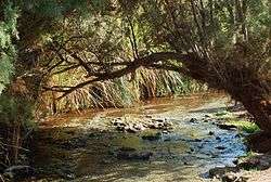
In 1847 William F. Lynch visited the place, and described the stream as: "The fountain is a shallow and clear stream of water, at the temperature of 84°, which flows from a cane−brake, near the base of the mountain. It is soft yet brackish, and there is no deposit of silicious or cretaceous matter, but it has a strong smell of sulphur."[7] He further "made an excursion along the base of the mountain, towards Ras es Feshkhah (cape of the stride), and gathered some specimens of conglomerate and some fresh−water shells in the bed of the stream. We were struck with the almost absence of round stones and pebbles upon the beach −the shore is covered with small angular fragments of flint. Started two partridges of a beautiful stone−colour, so much like the rocks, that they could only be distinguished when in motion. Heard the notes of a solitary bird in the cane−brake, which we could not identify. The statement that nothing can live upon the shores of the sea, is, therefore, disproved. The home and the usual haunt of the partridge may be among the cliffs above, but the smaller bird we heard must have its nest in the thicket."[8]
In 1851 de Saulcy noted extensive ruins north of the spring.[9]
Around 1860 Henry Baker Tristram visited, and noted: "Our prospects at Ain Feshkhah seemed as bright as at Jericho, and we were already prepared to pronounce the Dead Sea shore to be the shore of charmed life. Water, vegetation, birds and beasts, geology, and hot baths −everything was in abundance. The poor fountain has had, methinks, rather scurvy treatment at the hands of its biographers. [...] Perhaps our tastes were vitiated, or perhaps after the recent rains the mineral element was unusually diluted; but though the spring itself had a temperature of 82° Fahr. we found it tolerable. It made good tea and coffee, though with a slight flavour of soda, and we had no hesitation in determining to spend two days by its reeds."[10]

In 1883, the PEF's Survey of Western Palestine (SWP) noted: “In the neighbourhood of the Dead Sea there are also two springs of importance. The largest of these is 'Ain Feshkhah, near which is the little spring called 'Ain et Tannur. The water comes out from beneath the cliffs into a pool surrounded with canes, and runs over a shingly bed in several streams into the Dead Sea. The supply is copious and perennial, but has a slightly brackish taste and sulphurous smell. The colour in the pool is a deep green blue.”[11][12]
PEF Rock: Dead Sea water level marker
In October 1900, R. A. Stewart Macalister found a suitable rock towards the southern end of 'Ain Feshkah's reeds area, rigt next to the Dead Sea shore, which he found reaching some 20 ft above the water. He had the initials "PEF" carved into the rock face beneath a 8-9 inches long line. Macalister undertook a first measurement and noted that the line stood at exactly 14 ft above the water.[13]
Nature reserve
According to ARIJ, in 1969 Israel confiscated 97 dunams of land from the Palestinian village of al-Ubeidiya in order to establish the nature reserve.[14]
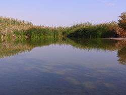
The saline wetlands of Ein Feshkha are the only known place in the world where populations of Blue and Dead Sea killifish (Nevit Hula and Nevit Yam Hamelakh) live side by side. The Israel Nature and Parks Authority and the Israeli Ministry of Agriculture are constructing pools in the area to preserve these native fish. Two of the pools are complete and are now populated by tens of thousands of fish. Measures are also being taken to preserve the tilapia population.[15]
Enot Tsukim is divided into three sections: the northern "closed reserve," the central "visitors reserve," and the southern "hidden reserve." The closed reserve is only open to scientists by special invitation. This section covers approximately 2,700 dunams. The 500-dunam visitors reserve features wading pools filled with natural spring water.[16]
Due to ecological concerns, the hidden reserve is closed to the public apart from tours on Fridays.[15]
Archaeology
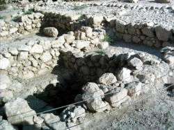
Excavations at Ein Feshkha were conducted by Roland de Vaux of the Ecole Biblique in 1956 and 1958. Hirschfeld excavated the site in 2001. The earliest structure at the site, located south of the spring, was an Iron Age II fort, constructed at a similar time to the earliest structures at Qumran and down the Dead Sea coast.
The spring at Ein Feshkha is now located 100 meters south of the main building found by de Vaux and at least 3 meters lower. In ancient times a spring, now dried up, just north of the main building supplied water. This ancient spring being several meters higher suggests that it was sweet, not brackish.[17] The complex is composed of a main building (24m by 18m) with central courtyard, an industrial installation with two plastered basins to its northeast and what appear to be stables to its west.
De Vaux showed that the Ein Feshkha complex was contemporary with the settlement at Qumran and theorized that they were inhabited by the same community and, while he dated traces to the period from 100 to 31 BCE, both Magness and Hirschfeld have concluded that the complex was Herodian, i.e. after 37 BCE.[18] The entrance was through two doors, side-by-side, to the east. There is a staircase in the southeast corner of the building, showing that there was an upper story.[19] A channel brings water from the spring through the wall to the north into a small rectangular tank on to each of the two basins. The purpose of this installation is unknown. It may have served as part of a tannery or for raising fish.[20] More recent analyses suggest it may have been used in indigo manufacturing,[21] date-wine preparation,[22] date-honey production[23] or opobalsam preparation.[24]
References
- Andrea Scozzari & Bouabid El Mansouri (2011) Water Security in the Mediterranean Region: An International Evaluation of Management, Control, and Governance Approaches, Springer, p.235.
- The Holy Land: An Oxford Archaeological Guide from Earliest Times to 1700, Jerome Murphy-O'Connor
- Ein Tzukim reserve
- Palmer, 1881, p. 339
- Palmer, 1881, p. 349
- Robinson and Smith, 1841, vol. 2, pp. 250, 252–253
- Lynch, 1849, p. 273
- Lynch, 1849, pp. 274−275
- Saulcy, 1854, vol 1, p. 36
- Tristram, 1865, p. 251
- Conder and Kitchener, 1883, SWP III, p. 171
- Hull, 1886, p. 22
- R. A. Stewart Macalister, Observation of Dead Sea Levels, Palestine Exploration Fund, Quarterly Statement for 1901, London 1901. Retrieved 14 April 2020.
- Al ‘Ubeidiya Town Profile, ARIJ, p. 19
- INPA to celebrate Israel’s wetlands this weekend, in honor of int’l day, Jerusalem Post
- "A green and changing oasis in the wasteland". Archived from the original on 2014-02-22. Retrieved 2014-02-12.
- Magness 2002, p.214.
- Taylor, 2006.
- Magness 2002, p.211.
- de Vaux, Roland, Archaeology and the Dead Sea Scrolls, (Oxford: The British Academy, 1973) p. 82
- Bélis 2006.
- Ehud Netzer, cited in Taylor 2006.
- Gideon Hadas, cited in Hirschfeld 2004, p. 207.
- Hirschfeld 2004, p. 207.
Bibliography
- Barag, Dan, "Ein-Feshkha" in Encyclopedia of the Dead Sea Scrolls Vol.1, Edd. Schiffman, L., VanderKam, James C. (Oxford: OUP, 2000) p. 237–238.
- Bélis, Mirielle, "The Workshops at ʿEin Fashkhah: A New Hypothesis," in: Humbert, J.-B., J. Zangenburg, and K. Galor (eds.), The Site of the Dead Sea Scrolls: Archaeological Interpretations and Debates (Leiden: Brill, 2006), (pp. 253- 262)
- Conder, C.R.; Kitchener, H.H. (1883). The Survey of Western Palestine: Memoirs of the Topography, Orography, Hydrography, and Archaeology. 3. London: Committee of the Palestine Exploration Fund.
- de Vaux, R., "Fouilles de Feshka, Rapport preliminaire." Revue Biblique 66 (1959), 225–255.
- Hirschfeld, Y., Qumran in Context: Reassessing the Archaeological Evidence, (Peabody, MA: Hendrickson, 2004). Ch. 4, pp. 183–209.
- Hull, E. (1886). The Survey of Western Palestine: Memoir on the Physical Geology and Geography of Arabia Petraea. 7. Committee of the Palestine Exploration Fund.
- Lynch, W.F. (1849). Narrative of the United States' Expedition to the River Jordan and the Dead Sea. London: Richard Bentley.
- Magness, J., Archaeology and the Dead Sea Scrolls (Grand Rapids: Eerdmans, 2002). Ch. 10, pp. 210–217.
- Netzer, E., Did Any Perfume Industry Exist at ʿEin Fashkhah? in: Israel Exploration Journal, 55 (2005), 97–100.
- Palmer, E.H. (1881). The Survey of Western Palestine: Arabic and English Name Lists Collected During the Survey by Lieutenants Conder and Kitchener, R. E. Transliterated and Explained by E.H. Palmer. Committee of the Palestine Exploration Fund.
- Robinson, E.; Smith, E. (1841). Biblical Researches in Palestine, Mount Sinai and Arabia Petraea: A Journal of Travels in the year 1838. 2. Boston: Crocker & Brewster.
- Saulcy, L.F. de (1854). Narrative of a journey round the Dead Sea, and in the Bible lands, in 1850 and 1851. 2, new edition. London: R. Bentley.
- Taylor, J., "Ein Fashkha", pp. 255–256, Vol. 6, of Encyclopaedia Judaica, Edition 2 (Macmillan Reference, 2006) ISBN 0-02-865928-7
- Tristram, H.B. (1865). Land of Israel, A Journal of travel in Palestine, undertaken with special reference to its physical character. London: Society for Promoting Christian Knowledge.
External links
| Wikimedia Commons has media related to Ain Feshkha. |
- Israel Nature & Parks Authority page on Ein Feshkha
- Ein Fashkhah, Thomson Gale, 2007
- Survey of Western Palestine, Map 18: IAA, Wikimedia commons