Edgerton, Ohio
Edgerton is a village in Williams County, Ohio, United States in the extreme northwest corner of the state. The population was 2,012 at the 2010 census.
Edgerton, Ohio | |
|---|---|
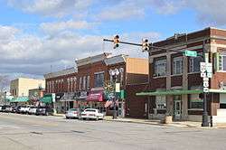 Michigan Ave. north of Indiana St. | |
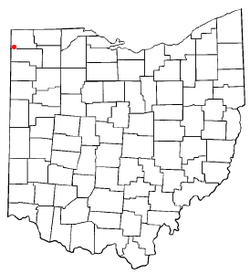 Location of Edgerton, Ohio | |
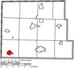 Location of Edgerton in Williams County | |
| Coordinates: 41°26′58″N 84°44′49″W | |
| Country | United States |
| State | Ohio |
| County | Williams |
| Government | |
| • Mayor | Lance L. Bowsher |
| Area | |
| • Total | 1.88 sq mi (4.87 km2) |
| • Land | 1.87 sq mi (4.84 km2) |
| • Water | 0.01 sq mi (0.03 km2) |
| Elevation | 840 ft (256 m) |
| Population | |
| • Total | 2,012 |
| • Estimate (2019[4]) | 1,999 |
| • Density | 1,075.9/sq mi (415.4/km2) |
| Time zone | UTC-5 (Eastern (EST)) |
| • Summer (DST) | UTC-4 (EDT) |
| ZIP code | 43517 |
| Area code(s) | 419 |
| FIPS code | 39-24486[5] |
| GNIS feature ID | 1048691[2] |
| Website | http://www.edgerton-ohio.com/ |
History
This area has long been known as the top of Ohio and was formerly a part of the Northwest Territory.[6] It was originally a portion of the Black Swamp region of Ohio. Edgerton was platted in 1854.[7] The village was named after Alfred P. Edgerton, a land agent.[8] A post office was established in 1854.[9] The village was incorporated on December 4, 1865.[10]
Geography
Edgerton is located at 41°26′58″N 84°44′49″W (41.449331, -84.746823).[11]
According to the United States Census Bureau, the village has a total area of 1.88 square miles (4.87 km2), of which 1.87 square miles (4.84 km2) is land and 0.01 square miles (0.03 km2) is water.[1]
Demographics
| Historical population | |||
|---|---|---|---|
| Census | Pop. | %± | |
| 1870 | 690 | — | |
| 1880 | 782 | 13.3% | |
| 1890 | 967 | 23.7% | |
| 1900 | 1,043 | 7.9% | |
| 1910 | 1,072 | 2.8% | |
| 1920 | 987 | −7.9% | |
| 1930 | 989 | 0.2% | |
| 1940 | 1,082 | 9.4% | |
| 1950 | 1,246 | 15.2% | |
| 1960 | 1,566 | 25.7% | |
| 1970 | 2,126 | 35.8% | |
| 1980 | 1,813 | −14.7% | |
| 1990 | 1,896 | 4.6% | |
| 2000 | 2,117 | 11.7% | |
| 2010 | 2,012 | −5.0% | |
| Est. 2019 | 1,999 | [4] | −0.6% |
| U.S. Decennial Census[12] | |||
2010 census
As of the census[3] of 2010, there were 2,012 people, 791 households, and 554 families living in the village. The population density was 1,075.9 inhabitants per square mile (415.4/km2). There were 865 housing units at an average density of 462.6 per square mile (178.6/km2). The racial makeup of the village was 97.7% White, 0.2% African American, 0.1% Native American, 0.4% Asian, 0.6% from other races, and 0.8% from two or more races. Hispanic or Latino of any race were 2.5% of the population.
There were 791 households of which 34.1% had children under the age of 18 living with them, 50.7% were married couples living together, 13.4% had a female householder with no husband present, 5.9% had a male householder with no wife present, and 30.0% were non-families. 26.2% of all households were made up of individuals and 12% had someone living alone who was 65 years of age or older. The average household size was 2.44 and the average family size was 2.88.
The median age in the village was 41.3 years. 24.6% of residents were under the age of 18; 7% were between the ages of 18 and 24; 23.3% were from 25 to 44; 27.5% were from 45 to 64; and 17.8% were 65 years of age or older. The gender makeup of the village was 47.3% male and 52.7% female.
2000 census
As of the census[5] of 2000, there were 2,117 people, 812 households, and 568 families living in the village. The population density was 1,137.8 people per square mile (439.5/km²). There were 862 housing units at an average density of 463.3 per square mile (178.9/km²). The racial makeup of the village was 97.45% White, 0.19% African American, 0.09% Native American, 0.05% Asian, 0.05% Pacific Islander, 0.90% from other races, and 1.28% from two or more races. Hispanic or Latino of any race were 2.08% of the population.
There were 812 households out of which 33.5% had children under the age of 18 living with them, 54.2% were married couples living together, 11.3% had a female householder with no husband present, and 30.0% were non-families. 25.2% of all households were made up of individuals and 12.4% had someone living alone who was 65 years of age or older. The average household size was 2.52 and the average family size was 3.01.
In the village, the population was spread out with 26.8% under the age of 18, 8.5% from 18 to 24, 27.8% from 25 to 44, 20.7% from 45 to 64, and 16.2% who were 65 years of age or older. The median age was 36 years. For every 100 females there were 90.7 males. For every 100 females age 18 and over, there were 83.4 males.
The median income for a household in the village was $38,750, and the median income for a family was $45,865. Males had a median income of $32,456 versus $23,646 for females. The per capita income for the village was $17,690. About 6.3% of families and 8.9% of the population were below the poverty line, including 13.4% of those under age 18 and 8.7% of those age 65 or over.
Education
Edgerton Local Schools District operates one elementary school and Edgerton High School.[13]
Edgerton has a public library, a branch of the Williams County Public Library.[14]
References
- "US Gazetteer files 2010". United States Census Bureau. Archived from the original on 2012-01-25. Retrieved 2013-01-06.
- "US Board on Geographic Names". United States Geological Survey. 2007-10-25. Retrieved 2008-01-31.
- "U.S. Census website". United States Census Bureau. Retrieved 2013-01-06.
- "Population and Housing Unit Estimates". Retrieved May 21, 2020.
- "U.S. Census website". United States Census Bureau. Retrieved 2008-01-31.
- A History of Edgerton, Ohio is found here Archived 2012-02-12 at the Wayback Machine.
- "County Information (Williams County, Ohio)". Archived from the original on February 22, 2014. Retrieved 3 November 2015.
- Overman, William Daniel (1958). Ohio Town Names. Akron, OH: Atlantic Press. p. 42.
- "Williams County". Jim Forte Postal History. Archived from the original on 20 November 2015. Retrieved 2 March 2015.
- "Village of Edgerton: History". Retrieved 30 November 2015.
- "US Gazetteer files: 2010, 2000, and 1990". United States Census Bureau. 2011-02-12. Retrieved 2011-04-23.
- "Census of Population and Housing". Census.gov. Retrieved June 4, 2015.
- "Edgerton Local School District". GreatSchools. Retrieved 3 March 2018.
- "Hours & Locations". Williams County Public Library. Retrieved 3 March 2018.
Municipalities and communities of Williams County, Ohio, United States | ||
|---|---|---|
| City |  Map of Ohio highlighting Williams County | |
| Villages | ||
| Townships | ||
| CDPs | ||
| Unincorporated communities | ||
| Ghost town | ||