Eastern Sudetes
The Eastern Sudetes (Polish: Sudety Wschodnie, Czech: Východní Sudety or Jesenická oblast) are the Eastern part of the Sudetes mountains on the border of the Czech Republic and Poland.[1] They stretch from the Kłodzko Valley and the Nysa Kłodzka River in the west down to the Moravian Gate in the east,[2][3] leading to the Outer Western Carpathians.[4]
| Eastern Sudetes | |
|---|---|
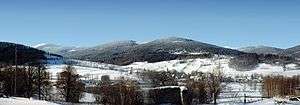 Panorama of Śnieżnik Mountains | |
| Highest point | |
| Peak | Praděd |
| Elevation | 1,491 m (4,892 ft) |
| Coordinates | 50°4′59″N 17°13′51″E |
| Geography | |
 Divisions of the Sudetes range system, Eastern Sudetes marked in green
| |
| Countries | Czech Republic and Poland |
| Regions | Pardubice, Olomouc (Czech Rep.) and Lower Silesia, Opole, Silesia (Poland) |
| Parent range | Sudetes range system |
Subdivision
The Eastern Sudetes consist of:
- Golden Mountains
- Śnieżnik Mountains
- Opawskie Mountains (Polish: Góry Opawskie) or Zlatohorská Highlands (Czech: Zlatohorská vrchovina)
- Hrubý Jeseník (High Ash Mountains)
- Hanušovická vrchovina (Hanušovice Highlands)
- Mohelnická brázda (Mohelnice depression)
- Zábřežská vrchovina (Zábřeh Highlands)
- Nízký Jeseník
References
- "Fig. 2. Geological map of the Jeseniky Mountains, Eastern Sudetes..." ResearchGate. Retrieved 2019-03-19.
- Copernicus, Index (2003). Water and Land Development. Index Copernicus.
- Wistuba, Małgorzata (2014-07-10). Slope-Channel Coupling as a Factor in the Evolution of Mountains: The Western Carpathians and Sudetes. Springer. ISBN 9783319058191.
- "Season end Eastern Sudetes - end of the ski season - Eastern Sudetes". www.skiresort.info. Retrieved 2019-03-19.
Silesia topics | |||||||||||||||||||||||||||||
|---|---|---|---|---|---|---|---|---|---|---|---|---|---|---|---|---|---|---|---|---|---|---|---|---|---|---|---|---|---|
| |||||||||||||||||||||||||||||
| |||||||||||||||||||||||||||||
| |||||||||||||||||||||||||||||
| |||||||||||||||||||||||||||||
| |||||||||||||||||||||||||||||

This article is issued from Wikipedia. The text is licensed under Creative Commons - Attribution - Sharealike. Additional terms may apply for the media files.