East Sandwich, Massachusetts
East Sandwich is a village and census-designated place (CDP) within the town of Sandwich in Barnstable County, Massachusetts, United States. The population was 3,940 at the 2010 census.[1]
East Sandwich, Massachusetts | |
|---|---|
 East Sandwich Friends Meeting House | |
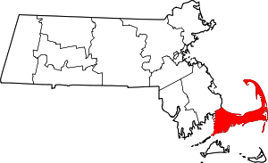
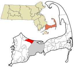 Location in Barnstable County and the state of Massachusetts. | |
| Coordinates: 41°44′16″N 70°25′23″W | |
| Country | |
| State | |
| County | Barnstable |
| Town | Sandwich |
| Area | |
| • Total | 19.6 km2 (7.6 sq mi) |
| • Land | 19.3 km2 (7.5 sq mi) |
| • Water | 0.3 km2 (0.1 sq mi) |
| Elevation | 9 m (30 ft) |
| Population (2010) | |
| • Total | 3,940 |
| • Density | 204.5/km2 (530/sq mi) |
| Time zone | UTC-5 (Eastern (EST)) |
| • Summer (DST) | UTC-4 (EDT) |
| ZIP code | 02537 |
| Area code(s) | 508 |
| FIPS code | 25-20380 |
| GNIS feature ID | 0616595 |
Geography
East Sandwich is located in the northeast portion of the town of Sandwich at 41°44′16″N 70°25′23″W (41.737654, -70.423178).[2] It is bordered by Cape Cod Bay to the north, the village of Sandwich to the west, U.S. Route 6 to the south, and the town of Barnstable to the east. The line between East Sandwich and Sandwich village is formed by Chipman Road, Crowell Road, Charles Street, and Water Street (Massachusetts Route 130). Massachusetts Route 6A is the main road through the community.
According to the United States Census Bureau, the East Sandwich CDP has a total area of 7.6 square miles (19.6 km2). 7.5 square miles (19.3 km2) of it is land, and 0.12 square miles (0.3 km2) of it (1.67%) is water.[1]
Demographics
At the 2010 census there were 3,940 people, 2,914 households, and 1,055 families in the CDP. The population density was 190.2/km² (520.75/mi²). There were 2,044 housing units at an average density of 105.5/km² (273.4/mi²). The racial makeup of the CDP was 98.68% White, 0.22% African American, 0.08% Native American, 0.35% Asian, 0.03% Pacific Islander, 0.22% from other races, and 0.43% from two or more races. Hispanic or Latino of any race were 0.67%.[3]
Of the 1,466 households 29.5% had children under the age of 18 living with them, 64.3% were married couples living together, 6.1% had a female householder with no husband present, and 28.0% were non-families. 22.6% of households were one person and 9.3% were one person aged 65 or older. The average household size was 2.54 and the average family size was 3.02.
The age distribution was 23.7% under the age of 18, 5.0% from 18 to 24, 21.8% from 25 to 44, 33.9% from 45 to 64, and 15.6% 65 or older. The median age was 45 years. For every 100 females, there were 94.2 males. For every 100 females age 18 and over, there were 90.8 males.
The median household income was $66,318 and the median family income was $74,457. Males had a median income of $53,304 versus $36,042 for females. The per capita income for the CDP was $32,676. About 1.5% of families and 2.2% of the population were below the poverty line, including 4.0% of those under age 18 and 1.9% of those age 65 or over.
Notable residents
- Peter Peltz (1915–2001), artist
- Tom Ellis (1932-2019), newscaster
References
- "Geographic Identifiers: 2010 Demographic Profile Data (G001): East Sandwich CDP, Massachusetts". U.S. Census Bureau, American Factfinder. Archived from the original on February 12, 2020. Retrieved December 9, 2013.
- "US Gazetteer files: 2010, 2000, and 1990". United States Census Bureau. 2011-02-12. Retrieved 2011-04-23.
- "U.S. Census website". United States Census Bureau. Retrieved 2008-01-31.