East Fork Township, Clinton County, Illinois
East Fork Township is one of fifteen townships in Clinton County, Illinois, USA. As of the 2010 census, its population was 400 and it contained 236 housing units.[2] Its name changed to Morris on June 1, 1874 and then back to East Fork.
East Fork Township | |
|---|---|
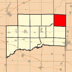 Location in Clinton County | |
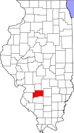 Clinton County's location in Illinois | |
| Coordinates: 38°41′57″N 89°11′49″W | |
| Country | United States |
| State | Illinois |
| County | Clinton |
| Established | November 4, 1873 |
| Area | |
| • Total | 37.62 sq mi (97.4 km2) |
| • Land | 31.58 sq mi (81.8 km2) |
| • Water | 6.04 sq mi (15.6 km2) 16.06% |
| Elevation | 476 ft (145 m) |
| Population (2010) | |
| • Estimate (2016)[1] | 402 |
| • Density | 12.7/sq mi (4.9/km2) |
| Time zone | UTC-6 (CST) |
| • Summer (DST) | UTC-5 (CDT) |
| ZIP codes | 62231, 62253, 62283 62882 |
| FIPS code | 17-027-21748 |
Geography
According to the 2010 census, the township has a total area of 37.62 square miles (97.4 km2), of which 31.58 square miles (81.8 km2) (or 83.94%) is land and 6.04 square miles (15.6 km2) (or 16.06%) is water.[2]
Cemeteries
The township contains these eight cemeteries: Brewster, Clark, Ebenezer, Hawkins, New Carter, Old Carter, Prairie Chapel and Prichett.
Rivers
- North Fork Kaskaskia River
School districts
- Carlyle Community Unit School District 1
- Patoka Community Unit School District 100
- Sandoval Community Unit School District 501
Political districts
- Illinois' 19th congressional district
- State House District 107
- State Senate District 54
References
- "East Fork Township, Clinton County, Illinois". Geographic Names Information System. United States Geological Survey. Retrieved 2010-01-10.
- United States Census Bureau 2007 TIGER/Line Shapefiles
- United States National Atlas
- "Population and Housing Unit Estimates". Retrieved June 9, 2017.
- "Population, Housing Units, Area, and Density: 2010 - County -- County Subdivision and Place -- 2010 Census Summary File 1". United States Census. Archived from the original on 2020-02-12. Retrieved 2013-05-28.
- "Census of Population and Housing". Census.gov. Retrieved June 4, 2016.
External links
Places adjacent to East Fork Township, Clinton County, Illinois | |
|---|---|
Municipalities and communities of Clinton County, Illinois, United States | ||
|---|---|---|
| Cities | Map of Illinois highlighting Clinton County | |
| Villages | ||
| Townships | ||
| Unincorporated communities | ||
| Ghost town | ||
| Footnotes | ‡This populated place also has portions in an adjacent county or counties | |
This article is issued from Wikipedia. The text is licensed under Creative Commons - Attribution - Sharealike. Additional terms may apply for the media files.