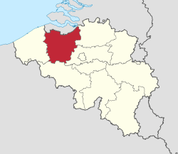
East Flanders
East Flanders (Dutch: Oost-Vlaanderen [ˌoːst ˈflaːndərə(n)] (![]()
East Flanders Dutch: Oost-Vlaanderen | |
|---|---|
 Flag  Coat of arms | |
 | |
| Coordinates: 51°00′N 03°45′E | |
| Country | |
| Region | |
| Capital (and largest city) | Ghent |
| Government | |
| • Governor | Jan Briers |
| Area | |
| • Total | 3,007 km2 (1,161 sq mi) |
| Population (1 January 2019 [2]) | |
| • Total | 1,515,064 |
| • Density | 504/km2 (1,310/sq mi) |
| HDI (2017) | 0.916[3] very high · 6th |
| Website | www |
History
During the short-lived Napoleonic Empire, most of the area of the modern province was part of the Department of Escaut, named after the River Scheldt. Following the defeat of Napoleon, the entity was renamed after its geographical location in the eastern part of the historic County of Flanders (now in the western portion of the current Flemish Region).
The provincial flag has a black lion with red tongue and claws, on a background of horizontal white and green stripes. This is a recent adaptation; formerly, East Flanders used the Flemish flag, a black lion on a yellow background, as in the current coat of arms. The old flag is still publicly used, e.g. for road signs.
Geography
The province has several geographic or tourist regions:
Important rivers are the Scheldt and the Leie which merge in Ghent. The Dender merges into the Scheldt in the city of Dendermonde.
Subdivisions
East Flanders is divided into 6 administrative arrondissements (districts), subdivided into a total of 60 municipalities. In addition, there are 3 judicial and 3 electoral arrondissements.
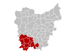
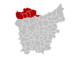
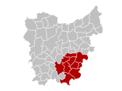
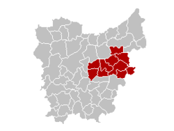
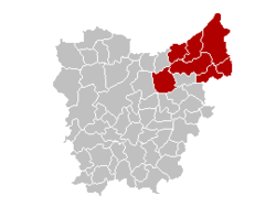
| District | Ghent District: | Oudenaarde District: | Eeklo District: | Aalst District: | Dendermonde District: | Sint-Niklaas District: |
| Location | 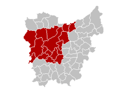 |
 |
 |
 |
 |
 |
|
BE.OV.GT
|
BE.OV.OD
|
BE.OV.EK
|
BE.OV.AL
|
BE.OV.DM
|
BE.OV.SN
| |
| Municipalities |
Demographics
The province has a population of almost 1.5 million. It had 734,000 inhabitants in 1830, when it was the most populated province of Belgium, and about a million in 1900. Population growth halted around the 1980s, but has increased again in the 21st century. Population figures in recent years is as follows:
| Year | Population |
|---|---|
| 1 January 1990 | 1,331,608 |
| 1 January 1995 | 1,349,382 |
| 1 January 2000 | 1,361,623 |
| 1 January 2005 | 1,380,072 |
| 1 January 2010 | 1,432,326 |
| 1 January 2015 | 1,477,346 |
| 1 January 2017 | 1,496,187 |
The capital and biggest city is Ghent, also the second largest city in the Flemish Region. Other smaller cities are Aalst, Sint-Niklaas and Dendermonde in the east of the province. The eastern part of the province, part of the Flemish Diamond, is more densely populated than the western part.
Economy
The Gross domestic product (GDP) of the province was 56.4 billion € in 2018. GDP per capita adjusted for purchasing power was 33,000 € or 109% of the EU27 average in the same year.[6]
Government
The provincial council (provincieraad) consists of 72 members which were last elected in the 2012 elections. Previously it consisted of 84 members. The council currently consists of the following political parties:
- N-VA (Flemish nationalists): 21 members
- CD&V (Christian democrats): 15 members
- Open VLD (liberals): 15 members
- sp.a (social democrats): 9 members
- Vlaams Belang (far-right nationalists): 6 members
- Groen (greens): 6 members
Six people chosen by and from the council form the daily government, called the deputation (deputatie). The deputation of East Flanders is a coalition of the political parties CD&V, Open Vld and sp.a. The biggest party in the council, N-VA, is not included.
The daily government is led by the governor, who is appointed by the Flemish Government. André Denys (VLD) has been the governor of East Flanders from 26 November 2004 until 21 January 2013.[7] Jan Briers, who is not member of a political party but was nominated by N-VA, succeeded him on 1 February 2013.
The province has a yearly budget of approximately 300 million euro.
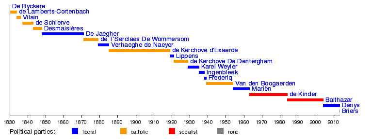
Governors
- 1830: Pierre De Ryckere
- 1830–1834: Werner de Lamberts-Cortenbach
- 1834–1836: Charles Vilain XIIII
- 1837–1843: Louis de Schiervel
- 1843–1848: Leander Desmaisières
- 1848–1871: Edouard De Jaegher (lib.)
- 1871–1879: Emile de T'Serclaes De Wommersom
- 1879–1885: Léon Verhaeghe de Naeyer (lib.)
- 1885–1919: Raymond de Kerchove d'Exaerde
- 1919–1921: Maurice Lippens (lib.)
- 1921–1929: André de Kerchove de Denterghem (lib.)
- 1929–1935: Karel Weyler (lib.)
- 1935–1938: Jules Ingenbleek (lib.)
- 1938–1939: Louis Frederiq (lib)
- 1939–1954: Maurice Van den Boogaerde
- 1954–1963: Albert Mariën (lib.)
- 1963–1984: Roger de Kinder (BSP)
- 1984–2004: Herman Balthazar (SP.A)
- 2004-2013: André Denys (VLD)
- 2013-present: Jan Briers (none; nominated by N-VA)
Timeline:
References
- https://bestat.statbel.fgov.be/bestat/crosstable.xhtml?view=90c1e218-dc4f-4827-824d-9b25abfefe59
- https://statbel.fgov.be/nl/themas/bevolking/structuur-van-de-bevolking
- "Sub-national HDI - Area Database - Global Data Lab". hdi.globaldatalab.org. Retrieved 2018-09-13.
- In isolation, Vlaanderen is pronounced [ˈvlaːndərə(n)].
- https://statbel.fgov.be/nl/themas/bevolking/structuur-van-de-bevolking
- "Regional GDP per capita ranged from 30% to 263% of the EU average in 2018". Eurostat.
- "The governor, province East Flanders". Archived from the original on 2006-11-04. Retrieved 2006-03-14.
External links
| Wikimedia Commons has media related to East Flanders. |
- (in Dutch) Official Website
| Communities |  | ||||||
|---|---|---|---|---|---|---|---|
| Regions and Provinces |
| ||||||
| Arrondissements | |||||||
| Municipalities by region | |||||||