Dusheti
Dusheti (Georgian: დუშეთი) is a town in Georgia, the administrative center of Dusheti Municipality, situated in the Mtskheta-Mtianeti region, 54 km northeast of the nation’s capital of Tbilisi.
Dusheti დუშეთი | |
|---|---|
Town | |
 | |
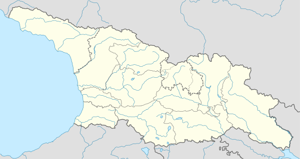 Dusheti Location of Dusheti in Georgia 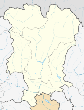 Dusheti Dusheti (Mtskheta-Mtianeti) | |
| Coordinates: 42°5′0″N 44°42′0″E | |
| Country | |
| Mkhare | Mtskheta-Mtianeti |
| Elevation | 900 m (3,000 ft) |
| Population (2014)[1] | |
| • Total | 6,167 |
| Time zone | UTC+4 (Georgian Time) |
History
Dusheti is located on both banks of the small, mountainous Dushetis-Khevi River in the foothills of the Greater Caucasus range at an elevation of 900 m above sea level. It functions as the center of the Dusheti Municipality which, beyond the town itself, includes several villages of the historical community of Pkhovi (Pshavi and Khevsureti). As of the 2014 all-Georgia census, the town had a population of about 6,167.[1]

Dusheti first appears in Georgian written records in 1215.[2] In the 17th century, it served as a residence of the local mountainous lords – the dukes of Aragvi – whose defiance to the Georgian crown more than once led to invasions and devastation of the town by the royal troops. After the abolition of the duchy of Aragvi in the 1740s, Dusheti passed to the crown but significantly declined. In 1801, the Russians took over and granted Dusheti a town status.[2] Next year, it became the center of Dushetsky Uyezd. The town and its environs were a scene of disturbances during the Russian Revolution of 1905, the peasants’ revolt in 1918, and an armed clash during the 1924 August Uprising against the Soviet rule. Dusheti was a center of agriculture and light industry during the Soviet era, but suffered an economic decline and population decrease in the years following the disintegration of the Soviet Union. Nowadays, most people work in service industries (banking, education, auto-repair, and retail) as well as subsistence farming. The town is also known for its khinkali, a meat-filled dumpling very popular in Georgia.
Economy
Transport
Dusheti has access by a paved road to the highway connecting Tbilisi and Stepantsminda. There is a regular bus traffic between Dusheti and Tbilisi.
Culture and recreation
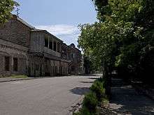
There are several historical and recreational places in and around Dusheti such as the Ananuri castle and the Bazaleti Lake. The town itself houses a number of architectural monuments including the 9th-10th-century church of St. George and the 18th-century palace of the Chilashvili family.
Climate
| Month | Jan | Feb | Mar | Apr | May | Jun | Jul | Aug | Sep | Oct | Nov | Dec | Year |
|---|---|---|---|---|---|---|---|---|---|---|---|---|---|
| Average high °C (°F) | 3 (37) |
4.1 (39.4) |
8.8 (47.8) |
15.1 (59.2) |
20.4 (68.7) |
23.8 (74.8) |
26.6 (79.9) |
26.7 (80.1) |
22.6 (72.7) |
17 (63) |
9.8 (49.6) |
4.7 (40.5) |
15.2 (59.4) |
| Daily mean °C (°F) | −1.5 (29.3) |
−0.5 (31.1) |
3.9 (39.0) |
9.1 (48.4) |
14.3 (57.7) |
17.7 (63.9) |
20.5 (68.9) |
20.5 (68.9) |
16.5 (61.7) |
11.3 (52.3) |
5.3 (41.5) |
0.4 (32.7) |
9.8 (49.6) |
| Average low °C (°F) | −5.9 (21.4) |
−5 (23) |
−1 (30) |
3.2 (37.8) |
8.3 (46.9) |
11.6 (52.9) |
14.4 (57.9) |
14.4 (57.9) |
10.4 (50.7) |
5.7 (42.3) |
0.8 (33.4) |
−3.8 (25.2) |
4.4 (39.9) |
| Average precipitation mm (inches) | 29 (1.1) |
37 (1.5) |
50 (2.0) |
75 (3.0) |
116 (4.6) |
102 (4.0) |
78 (3.1) |
62 (2.4) |
59 (2.3) |
57 (2.2) |
60 (2.4) |
40 (1.6) |
765 (30.2) |
| Source: Climate-Data.org[3] | |||||||||||||
Notable people
- Shota Khinchagashvili - a retired Georgian football player.
References
| Wikimedia Commons has media related to Dusheti. |
- "Population Census 2014". www.geostat.ge. National Statistics Office of Georgia. November 2014. Retrieved 2 June 2016.
- Душети (in Russian). Great Soviet Encyclopedia. Retrieved 21 June 2020.
- "Dusheti climate - Climate-Data.org". Climate-Data.org. Retrieved 2019-08-04.
Cities, towns and townlets in Georgia | ||
|---|---|---|
| Autonomous Republic of Abkhazia |   | |
| Autonomous Republic of Adjara | ||
| Guria | ||
| Imereti | ||
| Kakheti | ||
| Mtskheta-Mtianeti | ||
| Samegrelo-Zemo Svaneti | ||
| Samtskhe-Javakheti |
| |
| Racha-Lechkhumi and Kvemo Svaneti | ||
| Kvemo Kartli | ||
| Shida Kartli | ||
| Cities with local government | ||
| Capital city | ||