Dromore West
Dromore West (Irish: An Droim Mór Thiar[2]) is a village in County Sligo, Ireland.
Dromore West An Droim Mór Thiar | |
|---|---|
Village | |
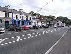 Dromore West lies on the N59 | |
 Dromore West Location in Ireland | |
| Coordinates: 54°15′06″N 8°53′35″W | |
| Country | Ireland |
| Province | Connacht |
| County | County Sligo |
| Elevation | 56 m (184 ft) |
| Population (2016)[1] | 227 |
| Irish Grid Reference | G418340 |
Dromore West is situated on the Dunneil River and sits between the Ox Mountains and the Atlantic coast. A river walk runs from just below the petrol station towards the sea. There is an old Napoleonic tower at the top of Ballykilcash hill, on the Wild Atlantic Way, near the village.
There are four public houses in the village, though not all open throughout the week. There are also two shops, a restaurant, a chemist, a hairdresser, health centre, bakery, Chinese take away, butcher and a post office and florist. The old parish church, near the school in Leharrow, had been replaced by a modern one close to the village on the Easkey road.

The annual local festival in Dromore West occurs on the August bank holiday weekend every year.
People
- Patrick Collins RHA, 1911 - 1994, was born in Dromore West.
References
- "Sapmap Area - Settlements - Dromore West". Census 2016. Central Statistics Office (Ireland). Retrieved 9 May 2018.
- "An Droim Mór Thiar/Dromore West". Placenames Database of Ireland. Government of Ireland - Department of Arts, Heritage and the Gaeltacht and Dublin City University. Retrieved 9 May 2018.
External links
Places in County Sligo | ||
|---|---|---|
| Towns | 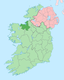 | |
| Villages and townlands |
| |
| Baronies | ||
| Islands | ||
| ||