Donnelsville, Ohio
Donnelsville is a village in Clark County, Ohio, United States. The population was 304 at the 2010 census. It is part of the Springfield, Ohio Metropolitan Statistical Area.
Donnelsville, Ohio | |
|---|---|
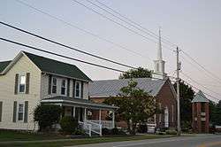 House and church on Main Street | |
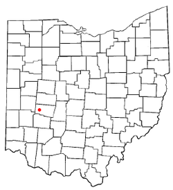 Location of Donnelsville, Ohio | |
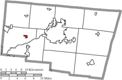 Location of Donnelsville in Clark County | |
| Coordinates: 39°55′6″N 83°56′51″W | |
| Country | United States |
| State | Ohio |
| County | Clark |
| Township | Bethel |
| Area | |
| • Total | 0.39 sq mi (1.0 km2) |
| • Land | 0.39 sq mi (1.0 km2) |
| • Water | 0 sq mi (0 km2) |
| Elevation | 932 ft (284 m) |
| Population | |
| • Total | 304 |
| • Estimate (2019)[4] | 261 |
| • Density | 780/sq mi (300/km2) |
| Time zone | UTC-5 (Eastern (EST)) |
| • Summer (DST) | UTC-4 (EDT) |
| ZIP code | 45319 |
| Area code(s) | 937, 326 |
| FIPS code | 39-22288[5] |
| GNIS feature ID | 1064547[2] |
History
Donnelsville was platted in 1830 by James Donnel, and named for him.[6] A post office called Donnelsville was established in 1840.[7]
Geography
Donnelsville is located at 39°55′6″N 83°56′51″W (39.918209, -83.947550).[8]
According to the United States Census Bureau, the village has a total area of 0.39 square miles (1.01 km2), all of it land.[1]
Demographics
| Historical population | |||
|---|---|---|---|
| Census | Pop. | %± | |
| 1850 | 196 | — | |
| 1860 | 233 | 18.9% | |
| 1880 | 194 | — | |
| 1890 | 243 | 25.3% | |
| 1900 | 200 | −17.7% | |
| 1910 | 202 | 1.0% | |
| 1920 | 166 | −17.8% | |
| 1930 | 210 | 26.5% | |
| 1940 | 254 | 21.0% | |
| 1950 | 285 | 12.2% | |
| 1960 | 273 | −4.2% | |
| 1970 | 278 | 1.8% | |
| 1980 | 219 | −21.2% | |
| 1990 | 276 | 26.0% | |
| 2000 | 293 | 6.2% | |
| 2010 | 304 | 3.8% | |
| Est. 2019 | 261 | [4] | −14.1% |
| U.S. Decennial Census[9] | |||
2010 census
As of the census[3] of 2010, there were 304 people, 114 households, and 84 families living in the village. The population density was 779.5 inhabitants per square mile (301.0/km2). There were 133 housing units at an average density of 341.0 per square mile (131.7/km2). The racial makeup of the village was 98.7% White, 0.3% Native American, 0.3% Asian, 0.3% from other races, and 0.3% from two or more races. Hispanic or Latino of any race were 0.3% of the population.
There were 114 households, of which 37.7% had children under the age of 18 living with them, 57.0% were married couples living together, 11.4% had a female householder with no husband present, 5.3% had a male householder with no wife present, and 26.3% were non-families. 21.9% of all households were made up of individuals, and 8.7% had someone living alone who was 65 years of age or older. The average household size was 2.67 and the average family size was 3.14.
The median age in the village was 39.3 years. 28.9% of residents were under the age of 18; 5.4% were between the ages of 18 and 24; 24.3% were from 25 to 44; 33% were from 45 to 64; and 8.6% were 65 years of age or older. The gender makeup of the village was 50.7% male and 49.3% female.
2000 census
As of the census[5] of 2000, there were 293 people, 98 households, and 81 families living in the village. The population density was 756.0 people per square mile (290.1/km2). There were 109 housing units at an average density of 281.3 per square mile (107.9/km2). The racial makeup of the village was 96.25% White, 0.34% African American, 0.34% Pacific Islander, 2.05% from other races, and 1.02% from two or more races. Hispanic or Latino of any race were 2.39% of the population.
There were 98 households, out of which 49.0% had children under the age of 18 living with them, 64.3% were married couples living together, 12.2% had a female householder with no husband present, and 17.3% were non-families. 13.3% of all households were made up of individuals, and 4.1% had someone living alone who was 65 years of age or older. The average household size was 2.99 and the average family size was 3.25.
In the village, the population was spread out, with 32.4% under the age of 18, 8.2% from 18 to 24, 30.7% from 25 to 44, 20.8% from 45 to 64, and 7.8% who were 65 years of age or older. The median age was 32 years. For every 100 females there were 107.8 males. For every 100 females age 18 and over, there were 120.0 males.
The median income for a household in the village was $63,125, and the median income for a family was $66,389. Males had a median income of $45,000 versus $47,750 for females. The per capita income for the village was $21,104. About 4.5% of families and 9.5% of the population were below the poverty line, including 15.3% of those under the age of eighteen and none of those 65 or over.
References
- "US Gazetteer files 2010". United States Census Bureau. Archived from the original on 2012-07-02. Retrieved 2013-01-06.
- "US Board on Geographic Names". United States Geological Survey. 2007-10-25. Retrieved 2008-01-31.
- "U.S. Census website". United States Census Bureau. Retrieved 2013-01-06.
- "Population and Housing Unit Estimates". Retrieved May 21, 2020.
- "U.S. Census website". United States Census Bureau. Retrieved 2008-01-31.
- Rockel, William Mahlon (1908). 20th Century History of Springfield, and Clark County, Ohio, and Representative Citizens. Biographical Publishing Company. p. 322.
- "Clark County". Jim Forte Postal History. Archived from the original on 4 March 2016. Retrieved 12 January 2016.
- "US Gazetteer files: 2010, 2000, and 1990". United States Census Bureau. 2011-02-12. Retrieved 2011-04-23.
- "Census of Population and Housing". Census.gov. Retrieved June 4, 2015.
Municipalities and communities of Clark County, Ohio, United States | ||
|---|---|---|
| Cities | 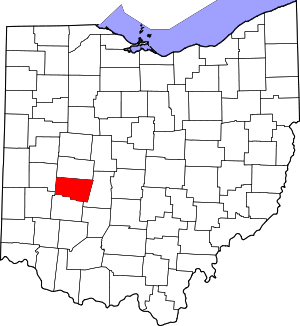 Map of Ohio highlighting Clark County | |
| Villages | ||
| Townships | ||
| CDPs | ||
| Unincorporated communities | ||
| Ghost towns | ||
| Footnotes | ‡This populated place also has portions in an adjacent county or counties | |