Dongeradeel
Dongeradeel (![]()
Dongeradeel Dongeradiel | |
|---|---|
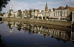 Canal through Dokkum | |
 Flag  Coat of arms | |
.svg.png) Location in Friesland | |
| Coordinates: 53°20′N 6°0′E | |
| Country | Netherlands |
| Province | Friesland |
| Established | 1 January 1984 |
| Government | |
| • Body | Municipal council |
| • Mayor | Magda Berndsen (D66) |
| Area | |
| • Total | 266.92 km2 (103.06 sq mi) |
| • Land | 167.21 km2 (64.56 sq mi) |
| • Water | 99.71 km2 (38.50 sq mi) |
| Elevation | 4 m (13 ft) |
| Time zone | UTC+1 (CET) |
| • Summer (DST) | UTC+2 (CEST) |
| Postcode | 9100–9156 |
| Area code | 0519 |
| Website | www |
History
Dongeradeel was created in 1984 from the merging of the old municipalities Westdongeradeel, Oostdongeradeel, and Dokkum. The new municipality is still colloquially referred to in the plural, "de Dongeradelen".
Population centres
Aalsum, Anjum, Bornwird, Brantgum, Dokkum, Ee, Engwierum, Foudgum, Hantum, Hantumeruitburen, Hantumhuizen, Hiaure, Holwerd, Jouswier, Lioessens, Metslawier, Moddergat, Morra, Nes, Niawier, Oosternijkerk, Oostmahorn, Oostrum, Paesens, Raard, Ternaard, Waaxens, Wetsens, Wierum.
Topography
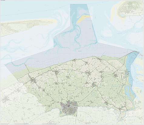
Dutch Topographic map of the municipality of Dongeradeel, June 2015.
Notable people
._Generaal-majoor%2C_genoemd_'de_ontzaglijke_generaal'_Rijksmuseum_SK-A-1401.jpeg)
.jpg)
- Ritske Jelmera (1383 in Ternaard - 1450) a Frisian chieftain who ruled the island of Ameland
- Johannes Phocylides Holwarda (1618 in Holwerd — 1651) a Frisian astronomer, physician, philosopher and academic
- Hans Willem van Aylva (ca.1633 in Holwerd - 1691) a Dutch soldier
- Balthasar Bekker (1634 in Metslawier – 1698) a Dutch minister and author of philosophical and theological works opposing superstition
- Nienke van Hichtum (1860 in Nes, Dongeradeel – 1939) a Frisian Dutch children's author
- Willem van der Woude (1876 in Oosternijkerk – 1974) a Dutch mathematician and academic
- Meindert DeJong (1906 in Wierum – 1991) a Dutch-born American writer of children's books
- Lou Dijkstra (1909 in Paesens – 1964) a Dutch speed skater, competed in the 1936 Winter Olympics
- Theo Hiddema (born 1944 in Holwerd) a Dutch lawyer, media personality and politician
- Sybe I. Rispens (born 1969 in Dokkum) a Dutch writer, scientist and entrepreneur
References
- "Collegeleden" [Members of the executive board] (in Dutch). Gemeente Dongeradeel. Archived from the original on 18 October 2013. Retrieved 8 September 2013.
- "Kerncijfers wijken en buurten" [Key figures for neighbourhoods]. CBS Statline (in Dutch). CBS. 2 July 2013. Retrieved 12 March 2014.
- "Postcodetool for 9101LP". Actueel Hoogtebestand Nederland (in Dutch). Het Waterschapshuis. Retrieved 8 September 2013.
External links

- Official website
Places adjacent to Dongeradeel | ||||||||||
|---|---|---|---|---|---|---|---|---|---|---|
| ||||||||||