Diomedes Lake
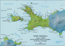
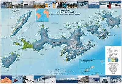
Diomedes Lake (Bulgarian: езеро Диомед, romanized: ezero Diomed, IPA: [ˈɛzɛro dioˈmɛt]) is the trapezoidal lake 480 m long in southeast-northwest direction and 112 m wide near the west extremity of Robbery Beaches on Byers Peninsula, Livingston Island in the South Shetland Islands, Antarctica. It has a surface area of 4.55 ha, and is separated from the waters of Barclay Bay by a 16 to 40 m wide strip of land, and surmounted by Penca Hill on the south and Enrique Hill on the northwest. The lake and its vicinity lye in a restricted zone of scientific importance to Antarctic microbiology, part of the Antarctic Specially Protected Area Byers Peninsula.[1] The area was visited by early 19th century sealers.[2]
| Diomedes Lake | |
|---|---|
 Diomedes Lake | |
| Location | Livingston Island, Antarctica |
| Coordinates | 62°36′07″S 61°06′40″W |
| Lake type | Glacial lake |
| Max. length | 480 metres (1,570 ft) |
| Max. width | 112 metres (367 ft) |
| Surface area | 4.55 hectares (11.2 acres) |
The feature is named after the mythical king Diomedes of Thrace.[1]
Location
Diomedes Lake is centred at 62°36′07″S 61°06′40″W which is 4.67 km southeast of Essex Point and 1.8 km west-northwest of Varadero Point. Detailed Spanish mapping in 1992, and Bulgarian mapping of the area in 2009 and 2017.
Maps
- Península Byers, Isla Livingston. Mapa topográfico a escala 1:25000. Madrid: Servicio Geográfico del Ejército, 1992
- L. Ivanov. Antarctica: Livingston Island and Greenwich, Robert, Snow and Smith Islands. Scale 1:120000 topographic map. Troyan: Manfred Wörner Foundation, 2010. ISBN 978-954-92032-9-5 (First edition 2009. ISBN 978-954-92032-6-4)
- L. Ivanov. Antarctica: Livingston Island and Smith Island. Scale 1:100000 topographic map. Manfred Wörner Foundation, 2017. ISBN 978-619-90008-3-0
- Antarctic Digital Database (ADD). Scale 1:250000 topographic map of Antarctica. Scientific Committee on Antarctic Research (SCAR). Since 1993, regularly upgraded and updated
See also
Notes
- Diomedes Lake. SCAR Composite Gazetteer of Antarctica
- L. Ivanov. General Geography and History of Livingston Island. In: Bulgarian Antarctic Research: A Synthesis. Eds. C. Pimpirev and N. Chipev. Sofia: St. Kliment Ohridski University Press, 2015. pp. 17–28.
References
- Diomedes Lake. SCAR Composite Gazetteer of Antarctica
- Bulgarian Antarctic Gazetteer. Antarctic Place-names Commission. (details in Bulgarian, basic data in English)
- M.A. de Pablo, M. Ramos and A. Molina. Snow cover evolution, on 2009-2014, at the Limnopolar Lake CALM-S site on Byers Peninsula, Livingston Island, Antarctica. Catena 149 (2017). pp. 538-547 (Map on Figure 1 featuring Diomedes Lake)
- Management Plan for Antarctic Specially Protected Area No. 126 Byers Peninsula. Measure 4 (2016), ATCM XXXIX Final Report. Santiago, 2016
External links
- Diomedes Lake. Adjusted Copernix satellite image
This article includes information from the Antarctic Place-names Commission of Bulgaria which is used with permission.