Diganibougou
Diganibougou or Diganidougou is a rural commune in the Cercle of Ségou in the Ségou Region of Mali. The commune lies to the north of the Niger River opposite the urban commune of Ségou and includes 22 villages in an area of approximately 571 square kilometers.[3] In the 2009 census the commune had a population of 13,879.[2] The administrative center (chef-lieu) is the village of Digani.
Diganibougou | |
|---|---|
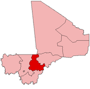
 Diganibougou Location in Mali | |
| Coordinates: 13°29′55″N 6°18′55″W | |
| Country | |
| Region | Ségou Region |
| Cercle | Ségou Cercle |
| Area | |
| • Total | 571 km2 (220 sq mi) |
| Elevation | 289 m (948 ft) |
| Population (2009 census)[2] | |
| • Total | 13,879 |
| • Density | 24/km2 (63/sq mi) |
| Time zone | UTC+0 (GMT) |
References
- Common and Fundamental Operational Datasets Registry: Mali, United Nations Office for the Coordination of Humanitarian Affairs. commune_mali.zip (Originally from the Direction Nationale des Collectivités Territoriales, République du Mali)
- Resultats Provisoires RGPH 2009 (Région de Ségou) (PDF) (in French), République de Mali: Institut National de la Statistique, archived from the original (PDF) on 2011-07-22.
- Communes de la Région de Ségou (PDF) (in French), Ministère de l’administration territoriale et des collectivités locales, République du Mali, archived from the original (PDF) on 2012-03-09.
External links
- Plan de Sécurite Alimentaire Commune Rurale de Diganidougou 2007-2011 (PDF) (in French), Commissariat à la Sécurité Alimentaire, République du Mali, USAID-Mali, 2007, archived from the original (PDF) on 2011-09-06, retrieved 2011-02-19.
- Situation des points d'eau modernes au Mali en 2003: Diganibougou (in French), Ministère des Mines, de l'Energie et de l'Eau, République du Mali, 2003.
This article is issued from Wikipedia. The text is licensed under Creative Commons - Attribution - Sharealike. Additional terms may apply for the media files.