Dholera
Dholera Dholera | |
|---|---|
Town | |
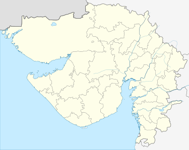 Dholera Location in Gujarat, India  Dholera Dholera (India) | |
| Coordinates: 22.248°N 72.195°E | |
| Country | |
| State | Gujarat |
| District | Ahmedabad |
| Population | |
| • Total | 1,208,888 |
| Languages | |
| • Official | Gujarati, Hindi |
| Time zone | UTC+5:30 (IST) |
| Vehicle registration | GJ |
| Website | gujaratindia |
Dholera SIR
The Dholera Special Investment Region[1] (DSIR) is proposed as a major new industrial hub to be located about 100 kilometres (km) south of Ahmedabad and 130 km from Gandhinagar within the Saurashtra peninsula. The site covers an area of about 920 sq km of land bordering the Gulf of Khambhat. The DSIR is the first investment region to be designated under the proposed Delhi–Mumbai Industrial Corridor Project (DMIC), a joint Indian and Japanese initiative to create a linear zone of development along a Dedicated Freight Corridor (DFC) railway line.
The Project Site
The DSIR covers a substantial area of land totalling to approximately 920 sq km and encompasses 19 villages of Dhandhuka Taluka and 3 villages of Barwala Taluka Barwala Taluka; total 22 villages of Ahmedabad District, making it the largest of the investment nodes proposed so far in the DMIC influence region. The site is strategically situated between the main industrial centres of Ahmedabad, Vadodara, Surat, Rajkot and Bhavnagar. It is linked to the major ports of Gujarat by State Highways but as yet has no direct rail connection. The nearest international airport is at Ahmedabad, although there is a current proposal to develop a new international airport to the north-east of the DSIR at Navagam Village. The existing population within the study area is only about 37,000 (census 2001), inhabiting small settlements. Agriculture is the principal land use and activity within the area, although the land is generally of poor quality and saline, especially close to the sea, and farm output is not high. Land values are therefore relatively low.
The Draft Development plan
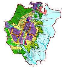
The purpose of the Draft Development Plan for the DSIR is to set out the framework for the long term growth of the area of the DSIR for a period of 30 years starting from 2010. It is intended to provide a broad development guide to all people with an interest in the future of the DSIR – including Central and State Governments, public and private bodies and corporations and the existing local inhabitants and landowners living within and adjoining the boundaries of the designated area. Report 1, The Draft Development Plan; presents the background, overall vision and elements for the DSIR and is complemented by Report 2, which contains the General Development Control Guidelines (GDCR). The Plan provides the overall spatial allocations for the new City and sets out a 30 year, phasing strategy including land uses, transport and major infrastructures and utilities and services.
Overall Vision and Objectives
The Draft Development Plan aims at the creation of an economically and socially balanced, new age City with world class infrastructure and high quality of life. Adoption of a sustainable approach across key components such as transportation, waste recycling, overall urban form and resource efficiency form the cornerstones of this Plan.
Plan Provision
A comprehensive assessment of the industrial and commercial potential was undertaken in order to determine the economic viability of the DSIR. The study, which included discussions with key stakeholders and detailed economic studies, concluded that the DSIR has the potential to attract a wide range of industrial uses, with particular strengths in the electronics and high tech industries, pharmaceuticals and biotechnology, heavy engineering and auto and general manufacturing sectors. Industrial employment, together with tourism and higher education will provide the economic foundations of the DSIR and generate about 343,000 ‘base’ jobs, which in turn would generate a further 483,630 jobs in support services. This is expected to create about 826,630 jobs in total over a 30 year time frame. It is forecasted that the jobs created in the DSIR will support a total population of about 2.5 million. There is expected to be some commuting to the DSIR from neighbouring urban centres like Ahmedabad and Bhavnagar, although a majority of the workforce would prefer to live in the new City. It is anticipated that housing will be required for a target resident population of about 2 million. The average family size in the DSIR is expected to be about 4, in line with national trends in urban areas, so it is necessary to plan for the construction of about 500,000 dwellings.
The Land Use Allocations
The land use is allocated based upon twelve spatial planning principles:
- Creation of a compact city;
- Integration of land uses;
- Accessibility of industrial zones;
- Focus of the city internally away from the central expressway, which will only have limited access;
- Separation of industrial and city traffic;
- Provision for a high quality public transport system;
- Development of a poly-centric structure that has a number of commercial and community nodes;
- Integration of existing villages into the new city;
- Conservation of the better agricultural land;
- Protection of the CRZ;
- Development of a strong landscape strategy; and
- A phased development programme that allows optimised investment.
Industrial and Economic Zones
A total of about 11,661 ha land area is allocated for industrial and logistics use in a number of linked mega parks, all of which have excellent access to the road and rail networks. In addition to the traditional industrial sectors, substantial additional land is allocated for knowledge based activities such as universities and research centres, bringing the total land area allocated for the economic sectors to over 12,891 ha. Additionally, about 12,000ha of agriculture land is allocated for future development.
Residential Areas
A wide range of housing types will be developed in the DSIR to meet the anticipated population of 2 million by 2030. A total of about 6,785 ha land area is allocated for housing, in addition to the 1,772 ha occupied by existing villages and their designated buffer zones. This provision is met through allocation for housing in various land use zones besides the Residential zone such as High Access Corridors, City Centre and Knowledge & IT. About 20 percent of the residential land will be allocated for the development of housing for low income groups, another 57 percent is allocated for medium income groups and the remaining 13 percent of the housing land is planned for high income groups. All residential areas will be mixed-incomes and housing will be developed with a comprehensive range of community facilities, including schools, medical facilities, neighbourhood retail and open space.
Government, Civic and Cultural Facilities
The DSIR will become a sizable city by 2030 and will therefore need to develop Government, civic and cultural services to match the requirements and expectations of the inhabitants and visitors. Major hospitals, colleges, Government offices and facilities such as post offices, fire stations, libraries, theatres and meeting halls, parks and sports venues and a range of religious buildings will be located in the central business district and the key commercial centres located in the different parts of the city.
Leisure and Tourism
Tourism is expected to play an important role in the economy of DSIR through traditional attractions such as religious sites and the Black Buck Sanctuary, as well as new ventures such as the proposed Film City, located in the Recreation Sports and Entertainment zone. A range of hotels will also be required to support the needs of business and industry, and these will be located within various zones such as City Centre, Knowledge & IT, High Access Corridors. Low development impact, Eco-resorts will be given special approval to be located in the Tourism & Resorts zone.
Green Spaces, Recreation and Agriculture
Spaces for recreation, open and green areas will make up more than 21 percent of the total DSIR and will ensure that the new city is an attractive and pleasant place to live and work with a high quality of life. A significant area of land will be allocated for agriculture in order to supply the new city with fresh farm produce. It will also act as a strategic land allotments should there be an additional demand for industrial land.
Phasing
For development in the DSIR to be efficient and cost effective, the distribution of land uses and infrastructure must be planned and provided in a phased and coordinated manner. The planning horizon of 30 years has been divided into 3 equal parts. The phasing strategy has been designed so as to optimise the use of available Government land in the initial phases and to build upon existing facilities and infrastructure. Development is then concentrated in one or two locations only so as to ensure that utility services can be provided economically. The Phase 1 development will comprise about 34 percent, Phase 2 about 36 percent and Phase 3 about 30 percent of the land under urbanisable zones. Development of the DSIR is recommended to start from Ambli Village in the north side, close to the existing State Highway (SH – 6) and then proceed generally southward either side of the expressway to Bavariyari Village.
Transport
The DSIR will be integrated into the regional transportation network by greatly improved road infrastructure and the provision of a new rail connection with freight and passenger services. This will link Dholera with Ahmedabad, Bhavnagar and the key ports of Pipavav, Mundra and Kandla. The proposed location of the new International Airport just to the north of Dholera at Navagam village will provide a major attraction for businesses in the DSIR. The Central Expressway corridor (SH-6) will give direct access to the city through five grade separated interchanges. But to avoid congestion and the growth of the informal sector on this road, service roads are not provided along the expressway. Properties abutting the SH-6 will only access their plots through the internal road network. A hierarchy of roads will distribute traffic in the city and there will be a high degree of separation between industrial and other traffic. The needs of pedestrians and cyclists will receive equal weight to that of motor traffic and there will be provision for a high quality public transport system, including street running trams.
Provision of Utilities
World-class facilities like power, water, telecommunications, gas and waste management facilities are proposed for the DSIR. An estimated 947 MLD fresh water will be required to meet demand by 2030. Initially this will be provided by the Narmada Canal through the Vallabhipur and Dholka Branch or the Pariyej and Kanewal Reservoirs but other potential sources of water, such as the Kalpasar Dam and desalination may be required in the future. A waste water management strategy will be formulated to manage, recycle and reuse industrial and domestic waste water and sewage treatment plants based upon aeration technology will be developed. There will be a substantial power demand from the DSIR totalling 1,700 MW, of which an estimated 1,000 MW will serve the industrial sector. In the initial phase of development, demand will be met by tapping into the nearby electrical supply network. In addition to relying on State generated energy, the industrial parks offer a suitable location for the construction of a gas fired power plant. About 1346 ha of land has been allocated for the development of a solar energy park. Gas and telecommunication networks have also been planned, as well as a strategy for solid waste management, including waste recycling.
Environment and Social Strategy
The environment strategy is based upon minimising potential impacts on important environmental areas and restricting development in the CRZ in order to protect future residents from flood hazards and to protect the local flora and fauna. Existing natural and man-made water bodies will be preserved and enhanced. New lakes and canals will be created through the widening and de-silting of existing rivers and watercourses and recreational areas and green spaces are established along their banks. The development of the DSIR will not involve the displacement or resettlement of any local inhabitants. A comprehensive strategy for integration of villages recommends the creation of buffer zones around existing village settlements. The strategy is supported with a model village plan illustrating the ideal mix of activities and uses within a sample village buffer zone. It is recommended that the Dholera Welfare Society be created to function as a village assistance cell in order to ensure that the benefits of the development trickle down at the village level. Villages will be provided with improved infrastructure and services, and their inhabitants provided with training programmes and support to enable them to participate fully in the employment opportunities that new development will bring about.
Cost of Infrastructure
The capital cost for infrastructure provisions to bring about the development of the DSIR is broadly estimated to be over 38,476 crores INR over the 30 year plan period. The cost of operating infrastructure elements is estimated to be over 304.60 crores INR in Phase 528.66 crores INR in Phase 2 and 251.04 crores INR in Phase 3.
Implementation Framework
Under the provisions of the Gujarat Special Investment Region Act, 2009; the DSIR will be governed by the Dholera Special Investment Development Authority (DSIRDA), with the Gujarat Infrastructure Development Board (GIDB) as its apex authority. The Plan recommends adoption of a phased land management strategy in order to achieve speedy implementation at relatively low cost. This will involve, in the first instance, limited compulsory land acquisition for critical infrastructure elements in order to kick start the development. Thereafter the application of Town Planning Scheme can be applied, once the market for the resale of land is established and farmers are able to resell their land at a profit. The framework sets the time line for review of the Draft Development plan on a regular basis. A review of provisions is recommended every five years and a more thorough review and revised atleast once in every ten years.
See also
- Dholera International Airport
- Delhi Mumbai Industrial Corridor Project
References
- "dholerasir.com, Gandhinagar". Retrieved 3 December 2019.