Dhola Post
Dhola Post was a border post set up by the Indian Army in June 1962, in the Namka Chu river valley located north of the McMahon Line.[1][2] On 20 September, the post was attacked by Chinese forces from the Thagla Ridge to the north, and sporadic fighting continued till 20 October when an all-out attack was launched by China leading to the Sino-Indian War. Facing an overwhelming force, the Indian Army evacuated the Dhola Post as well as the entire area of Tawang, retreating to Sela and Bomdila.[3]
Dhola post | |
|---|---|
border post | |
 Dhola post  Dhola post | |
| Coordinates: 27°49′05″N 91°40′25″E | |
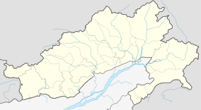
| Country | India |
| Province | Arunachal Pradesh |
| District | Tawang |
Location and background
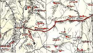
The map attached to the 1914 Simla Convention, displaying the border between Tibet and the Assam Himalayan region (called the McMahon Line), showed a straight line border running east–west in the vicinity of the Nyamjang Chu river, cutting across a ridge called Tsangdhar. Immediately to the north of Tsangdhar ridge is a higher Thagla Ridge (or Tang La Ridge or Che Dong in Chinese nomenclature). The Namka Chu river, 16 miles (26 km) long,[4] flows in the valley between the two ridges, west to east, joining Nyamjang Chu at the bottom.
While the Thagla Ridge is to the north of the McMahon Line, India believed that the 1914 map incorrectly depicted the border due to inadequate exploration at that time. India held that if the boundary was supposed to follow the Himalayan watershed, then the correct border should have been on the Thagla Ridge.[2]
Establishment
In late 1961, India settled on what came to be called a 'forward policy' to circumvent the Chinese expansion into the disputed areas, asking its Army to "go as far as practicable ... and be in effective occupation of the whole frontier".[5] In the northeast frontier, Assam Rifles was tasked with setting up posts all along the McMahon Line.[6] The Dhola Post came into being as part of this effort.[7]
The Dhola Post was located on the northern slopes of the Tsangdhar ridge, close to the Namkha Chu valley, at about 300 metres above the level of the river. The army officer who commanded the Assam Rifles platoon, Captain Mahabir Prasad, questioned the siting of the post immediately after returning to base. He informed the Divisional Headquarters that, according to the local Intelligence Bureau sources, the Chinese knew about the Dhola Post and regarded the location as Chinese territory. They would be ready to occupy it as soon as they received orders.[7]
The Divisional Commander, Maj. Gen. Niranjan Prasad, queried the higher officers whether the territory was properly Indian, but did not receive a response. His superior, Lt. Gen. Umrao Singh commanding the XXXIII Corps, expressed his own doubts about the legality of the territory, who was also greeted with no response.[8] Eventually the matter was referred to Sarvepalli Gopal heading the Historical Division of the Ministry of External Affairs, who answered in the affirmative, citing the Officials' Report.[9]
Skirmishes
On September 8, 1962, a Chinese unit launched a surprise attack on an Indian posts at Dhola on the Thagla Ridge, which is deep in Chinese territory by even India's own claim.[10][11]
Notes
References
- Hoffmann, India and the China Crisis (1990), pp. 108–110.
- Raghavan, War and Peace in Modern India (2010), pp. 293–294.
- Raghavan, War and Peace in Modern India (2010), pp. 296–305.
- Hoffmann, India and the China Crisis (1990), p. 139.
- Raghavan, War and Peace in Modern India (2010), pp. 275–276.
- Hoffmann, India and the China Crisis (1990), p. 108.
- Hoffmann, India and the China Crisis (1990), p. 110.
- Hoffmann, India and the China Crisis (1990), pp. 110-111.
- Hoffmann, India and the China Crisis (1990), p. 111.
- Maxwell, Neville, India's China War, New York, Pantheon, 1970.
- Calvin, James, THE CHINA - INDIA BORDER WAR (1962), Marine Corps Command and Staff College, 1984.
Bibliography
- Hoffmann, Steven A. (1990), India and the China Crisis, University of California Press, ISBN 978-0-520-06537-6
- Raghavan, Srinath (2010), War and Peace in Modern India, Palgrave Macmillan, ISBN 978-1-137-00737-7
- Sinha, P.B.; Athale, A.A.; Prasad, S. N. (1992), History of the Conflict with China, 1962 (PDF), History Division, Ministry of Defence, Government of India
- Primary sources
- India. Ministry of External Affairs (1959), Notes, Memoranda and Letters Exchanged and Agreements Signed Between the Governments of India and China: 1954-1959 (PDF), Ministry of External Affairs
- India. Ministry of External Affairs (1959), Notes, Memoranda and Letters Exchanged and Agreements Signed Between the Governments of India and China: September - November 1959, White Paper No. II (PDF), Ministry of External Affairs
- India. Ministry of External Affairs (1960), Notes, Memoranda and Letters Exchanged and Agreements Signed Between the Governments of India and China: November 1959 - March 1960, White Paper No. III (PDF), Ministry of External Affairs
- India. Ministry of External Affairs (1960), Notes, Memoranda and Letters Exchanged and Agreements Signed Between the Governments of India and China: April - November 1960, White Paper No. IV (PDF), Ministry of External Affairs
- India. Ministry of External Affairs (1961), Notes, Memoranda and Letters Exchanged and Agreements Signed Between the Governments of India and China: November 1960 - November 1961, White Paper No. V (PDF), Ministry of External Affairs
- India. Ministry of External Affairs (1962), Notes, Memoranda and Letters Exchanged and Agreements Signed Between the Governments of India and China: November 1961 - June 1962, White Paper No. VI (PDF), Ministry of External Affairs
- India. Ministry of External Affairs (1962), Notes, Memoranda and Letters Exchanged and Agreements Signed Between the Governments of India and China: July 1962 - October 1962, White Paper No. VII (PDF), Ministry of External Affairs