Devarayanadurga
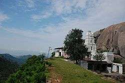
Devarayanadurga is a temple town and hill station located in the district of Tumkuru in the state of Karnataka in India. The rocky hills are surrounded by forest and the hilltops are dotted with several temples including the Yoganarasimha and the Bhoganarasimha temples and an altitude of 1204 metres.[1]
Devarayanadurga Anebiddasari Jadakanadurga | |
|---|---|
Village | |
 Devarayanadurga | |
| Nickname(s): Devarayanadurga | |
 Devarayanadurga Location in Karnataka, India | |
| Coordinates: 13.375°N 77.213°E | |
| Country | |
| State | Karnataka |
| District | Tumkuru |
| Government | |
| • Type | Gram |
| • Body | Panchayat of Aregujjanahalli |
| Area | |
| • Total | 2.3 km2 (0.9 sq mi) |
| Area rank | 69th:Tumkuru |
| Population (2011) | |
| • Total | 219 |
| • Rank | 174th:Tumkuru |
| • Density | 95/km2 (250/sq mi) |
| Languages | |
| • Official | Kannada |
| Time zone | UTC+5:30 (IST) |
| PIN CODE | 572 146 |
| Telephone code | 0816 |
| ISO 3166 code | IN-KA |
| Vehicle registration | KA-06 |
| Website | karnataka |
Devarayanadurga, when translated means “Fort of the God", and got its current name after the Mysore ruler Chikka Devaraja Wodeyar captured it on one of his victorious feats.[2]
See also
References
| Wikimedia Commons has media related to Devarayanadurga. |
- "Devarayanadurga Temple". Archived from the original on 29 June 2012. Retrieved 7 July 2012.
- "Devarayanadurga| Devarayanadurga Temples| Trekking Devarayanadurga". Karnataka.com. 21 December 2016. Retrieved 19 June 2020.
This article is issued from Wikipedia. The text is licensed under Creative Commons - Attribution - Sharealike. Additional terms may apply for the media files.