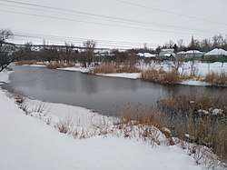
Derkul
The Derkul is a left tributary of the Donets located in the Luhansk Oblast of northeast Ukraine, on the border to the Rostov Oblast of Russia.[1] It is 163 kilometres (101 mi) long, and has a catchment area of 5,180 square kilometres (2,000 sq mi).[2]
| Derkul | |
|---|---|
 | |
| Native name | Деркул |
| Location | |
| Country | Russia, Ukraine |
| Region | Rostov Oblast, Luhansk Oblast |
| Physical characteristics | |
| Source | |
| ⁃ location | Central Russian Upland |
| ⁃ coordinates | 49°38′1″N 39°38′5″E |
| Mouth | |
⁃ location | Donets |
⁃ coordinates | 48°35′12″N 39°41′26″E |
| Length | 163 km (101 mi)[1][2] |
| Basin size | 5,180 km2 (2,000 sq mi)[1][2] |
| Basin features | |
| Progression | Donets→ Don→ Sea of Azov |
The Derkul rises north of Markivka in the Ukrainian Luhansk Oblast on the western foothills of the Central Russian Upland. It flows mainly in a southerly direction through a hilly plain in the northeast of the oblast and after 163 km flows on the left into the Siverskyi Donets. In parts of the lower course, it forms a border of the Rostov Oblast of Russia. The Derkul flows through the urban-type settlement of Bilovodsk at the lower reaches. The most important tributary of the Derkul is the Polnaya from the left.
References
- Деркул (река в Ворошиловградской обл.), Great Soviet Encyclopedia
- «Река Деркул (Деркуль)», Russian State Water Registry