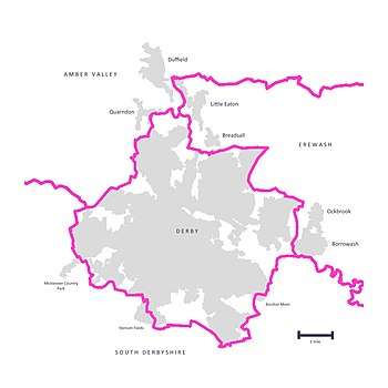
Derby Built-up Area
The Derby Built-up Area (BUA) or Derby Urban Area is an area including Derby and adjoining built-up districts of Derbyshire, in the East Midlands of England, including Borrowash and Duffield. The Office for National Statistics defines an urban area as one which is built upon, with nearby areas linked if within 200 metres.[1][2]
It had a total population of 270,468 at the time of the 2011 census.[3] An increase of over 10% since the 2001 census recorded population of 236,738;[4] comprising population increases since 2001 along with new minor residential areas, and larger sub-divisions.
Geography
The Derby built-up area is considered to be most of the city, as well as outlying villages within the districts of Amber Valley and Erewash which adjoin the city. This overall area is, by ONS' figures, the 29th largest in the UK.
Due to methods of measuring linked areas being redefined for the 2011 census, Breadsall, Duffield and Little Eaton were included. However, Quarndon is not considered to be a component due to being marginally too distant.
It extends south to small adjoining estates in the South Derbyshire district, at Boulton Moor/Thulston Fields, Stenson Fields, and the Mickleover Country Park residential development (The Pastures)[5] within Burnaston parish.
New or currently being built estates on the perimeter such as Regent's Place in Chellaston,[6] Langley Country Park in Mackworth parish,[7] and Buttercup Leys in Bolton Moor[8] will be added in 2021 and future censuses.
The urban area is bounded to the east by a narrow gap between Borrowash and Draycott (to the west of the Breaston urban area sub-division of the Nottingham BUA). It is also close to other nearby urban areas to the north.
| Urban subdivision | Population | District | |
|---|---|---|---|
| 2001 census | 2011 census | ||
| Derby | 229,407 | 255,394 | City of Derby |
| Borrowash | 5,621 | 7,335 | Erewash |
| Duffield | 5,046 | Amber Valley | |
| Little Eaton | 1,920 | Erewash | |
| Ockbrook | 1,710 | Erewash | |
| Breadsall | 773 | Erewash | |
| Total | 236,738 | 270,468 | |
Notes:
- Ockbrook included in Borrowash figure in 2011.
- Derby unitary authority 2001/2011 population figures were 221,716 and 244,625,[9] the table ONS subdivision figures also containing small adjoining estates outside the city boundary at Boulton Moor/Thulston Fields, Stenton Fields, and Burnaston.
- Quarndon, although very close to the BUA is considered to be a separate area.
See also
- List of urban areas in the United Kingdom
- Nottingham Urban Area
- List of metropolitan areas in the United Kingdom
References
- "ONS 2011 Built-up Areas - Methodology and Guidance" (PDF). www.ons.gov.uk.
- "Census 2001: Key Statistics for urban areas in England and Wales" (PDF). webarchive.nationalarchives.gov.uk. Archived from the original on 5 January 2016.CS1 maint: BOT: original-url status unknown (link)
- "2011 Census – Built-up areas". ONS. Retrieved 3 July 2013.
- Office for National Statistics: Census 2001, Key Statistics for urban areas
- http://burnaston-online.co.uk/history.htm
- https://www.persimmonhomes.com/regents-place-10614
- https://www.redrow.co.uk/developments/langley-country-park-452502
- https://www.rightmove.co.uk/developer/branch/Persimmon-Homes/Buttercup-Leys-186473.html
- "Census information | Derby City Council". www.derby.gov.uk. Retrieved 2 June 2017.
External links
- Office for National Statistics: Census 2001, Key Statistics for urban areas
- Office for National Statistics: Census 2011, Key Statistics for urban areas (KS101EW - Usual resident population)
- Map depicting the Derby BUA area
| History | |
|---|---|
| Geography | |
| Politics | |
| Venues and attractions | |
| Transport | |
| Education and health | |
| Religion | |
| Sport | |
| Media | |
| |