Derby, Western Australia
Derby (/ˈdɜːrbi/ DUR-bee)[3] is a town in the Kimberley region of Western Australia. At the 2016 census, Derby had a population of 3,325 with 47.2% of Aboriginal descent.[1] Along with Broome and Kununurra, it is one of only three towns in the Kimberley to have a population over 2,000. Located on King Sound, Derby has the highest tides in Australia, with the peak differential between low and high tide reaching 11.8 metres (39 ft).[4]
| Derby Western Australia | |||||||||
|---|---|---|---|---|---|---|---|---|---|
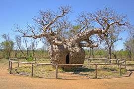 Local legend claims this boab tree near Derby was used as a prison, hence the name the "Boab Prison Tree" | |||||||||
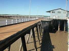 Low tide at the Derby wharf on King Sound | |||||||||
 Derby | |||||||||
| Coordinates | 17°18′20″S 123°38′02″E | ||||||||
| Population | 3,325 (2016 census)[1] | ||||||||
| Established | 1883[2] | ||||||||
| Postcode(s) | 6728 | ||||||||
| Elevation | 8 m (26 ft) | ||||||||
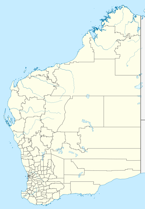
| Location |
| ||||||||
| LGA(s) | Shire of Derby-West Kimberley | ||||||||
| State electorate(s) | Kimberley | ||||||||
| Federal Division(s) | Durack | ||||||||
| |||||||||
History
During World War II, Derby was bombed by Japanese planes because of an air base and jetty that was used by Australian forces. More recently, refugees were housed at Royal Australian Air Force Base Curtin, however the detention center was closed in 2014.[5]
Derby was famous in the 1920s as the terminus of the first scheduled aviation service in Australia, West Australian Airways Ltd. Their service began with their first flight on 5 December 1921. At one time the Perth to Derby service was the world’s longest passenger airline route,
In 1968 the town had a population of approximately 1,500 many employed at the meatworks. A A$900,000 beef road from Glenroy Station to Derby was completed the same year to assist with the development of beef processing. A A$2 million steel and concrete jetty was built in 1965 to provide adequate port facilities for the shipment of live cattle.[6]
Population
According to the 2016 census of Population, there were 3,325 people in Derby.
- Aboriginal and Torres Strait Islander people made up 47.2% of the population.
- 77.4% of people were born in Australia. The next most common country of birth was New Zealand at 3.4%.
- 72.5% of people spoke only English at home. Other languages spoken at home included Kriol at 6.2%.
- The most common responses for religion were No Religion 27.7% and Catholic 26.8%.[1]
Culture
Derby is rich in cultural diversity, with the local Indigenous culture playing a large part in the community. The Mowanjum Festival is held annually at Mowanjum Community and features a showcase of traditional art.
The Boab festival is a week-long festival that includes traditional events such as mud football, watermelon seed spitting, the Mardi Gras and other festivities.[7]
Historically, Derby has played a major role in the Australian Royal Flying Doctor Service for the Kimberley Region.
The Kimberley School of the Air is located in Derby. The school provides education to isolated Primary-aged children living on cattle stations and in remote Aboriginal communities scattered throughout the 423,517 square kilometres (163,521 sq mi) Kimberley region.[8]
Derby has two other schools, Holy Rosary School Derby and Derby District High School. Derby District High School follows Chris Sarra's vision of 'Stronger Smarter', which aims to raise the expectations of the school as a community.
Wharfinger’s House Museum tells the story of the aviation history of the town as well as the history of the Port.
Norval Gallery is a popular tourist destination and showcases the work of award winning artist Mark Norval as well as a broad selection of indigenous artwork from across the Kimberley.
Economy
There is employment in the pastoral and mining industries, as well as administration and tourism. There is oil at Blina, diamond mining at Ellendale. Granite is quarried from the King Leopold Ranges and lead and zinc from Cadjebut and an Iron ore mine at Koolan Island. A major mineral sands mining project is being developed at Thunderbird 100 km west of Derby. In 1997 the Derby wharf, which was closed in the 1980s, was re-opened for barging operations for the export of lead and zinc. Tourism bolsters the local economy between the months of May and September.
The Derby Leprosarium on the outskirts of the town was one of two in Western Australia that helped to contain an epidemic of the disease from the 1930s to the 1960s.[9]
Climate
Derby has a hot semi-arid climate with a short, highly variable wet season lasting from late December to March. The wet season features hot, humid days and nights and erratic downpours. In some years, such as 1923–24 and 1951–52, there was no wet season; however, in other years, such as 1999–2000, more than the average annual rainfall fell in a month. Derby can be affected by severe tropical cyclones. The dry season lasts from April to November and features very little rain, warm to hot daytime temperatures, and mild to cool nights. Extremes of temperature range from 47.8 °C (118.0 °F) on 17 November 1968 to 5.0 °C (41.0 °F) on 21 July 1965, while the wettest month on record was January 1917, when 803.6 millimetres (31.64 in) of rain fell, including the wettest day, 7 January 1917, when 418.3 millimetres (16.47 in) was recorded.
| Climate data for Derby Post Office (1883 to 1997) | |||||||||||||
|---|---|---|---|---|---|---|---|---|---|---|---|---|---|
| Month | Jan | Feb | Mar | Apr | May | Jun | Jul | Aug | Sep | Oct | Nov | Dec | Year |
| Record high °C (°F) | 45.2 (113.4) |
43.8 (110.8) |
42.8 (109.0) |
42.1 (107.8) |
39.4 (102.9) |
36.2 (97.2) |
36.7 (98.1) |
39.5 (103.1) |
42.8 (109.0) |
43.4 (110.1) |
47.8 (118.0) |
45.7 (114.3) |
47.8 (118.0) |
| Average high °C (°F) | 35.0 (95.0) |
34.7 (94.5) |
35.3 (95.5) |
35.2 (95.4) |
32.4 (90.3) |
30.1 (86.2) |
29.6 (85.3) |
31.7 (89.1) |
34.2 (93.6) |
35.7 (96.3) |
36.5 (97.7) |
36.2 (97.2) |
33.9 (93.0) |
| Average low °C (°F) | 25.9 (78.6) |
25.6 (78.1) |
25.2 (77.4) |
22.7 (72.9) |
19.2 (66.6) |
16.2 (61.2) |
14.7 (58.5) |
16.2 (61.2) |
19.4 (66.9) |
23.0 (73.4) |
25.5 (77.9) |
26.4 (79.5) |
21.7 (71.1) |
| Record low °C (°F) | 17.1 (62.8) |
19.4 (66.9) |
18.8 (65.8) |
13.9 (57.0) |
9.6 (49.3) |
5.8 (42.4) |
5.0 (41.0) |
8.0 (46.4) |
12.4 (54.3) |
14.0 (57.2) |
18.8 (65.8) |
20.3 (68.5) |
6.0 (42.8) |
| Average rainfall mm (inches) | 181.7 (7.15) |
157.3 (6.19) |
108.9 (4.29) |
31.0 (1.22) |
22.1 (0.87) |
10.4 (0.41) |
5.9 (0.23) |
1.3 (0.05) |
0.3 (0.01) |
2.5 (0.10) |
16.2 (0.64) |
83.1 (3.27) |
620.7 (24.43) |
| Average rainy days (≥ 0.2 mm) | 11.8 | 10.6 | 7.9 | 2.4 | 1.4 | 1.0 | 0.5 | 0.1 | 0.1 | 0.5 | 1.9 | 6.5 | 44.7 |
| Source: Bureau of Meteorology[10] | |||||||||||||
References
- Australian Bureau of Statistics (27 June 2017). "Derby ( Urban Centre)". 2016 Census QuickStats. Retrieved 5 January 2018.

- "Notes from Roebuck Bay". The Daily News. Perth, WA. 12 July 1883. p. 3. Retrieved 7 June 2018.
- Macquarie Dictionary, Fourth Edition (2005). Melbourne, The Macquarie Library Pty Ltd. ISBN 1-876429-14-3
- Derby tides at derbytourism.com.au Archived 18 February 2007 at the Wayback Machine. Retrieved 7 January 2007
- Collins, Ben (19 June 2015). "Derby refugee recession after Curtin detention centre closure". Australian Broadcasting Corporation. Retrieved 3 September 2016.
- "Government Members Mining and National Development Committees Fact Finding Tour July 21st-28th 1968" (PDF). Commonwealth of Australia. 1968. Retrieved 3 September 2016.
- http://www.derbyboabfestival.org.au/
- "Kimberley School of the Air". Derby, WA. Archived from the original on 3 January 2017. Retrieved 2 January 2017.
- "Archived copy". Archived from the original on 5 September 2012. Retrieved 27 August 2012.CS1 maint: archived copy as title (link)
- Climate statistics for Australian locations - Derby Post Office
Further reading
- Derby's history at a glance: A chronology of Derby history, 1688-1992. Boab Babbler, 26 February 1993, p. 20
| Wikimedia Commons has media related to Derby, Western Australia. |
| Authority control |
|
|---|