Delphos, Kansas
Delphos is a city in Ottawa County, Kansas, United States.[1] As of the 2010 census, the city population was 359.[5] The community was named after Delphos, Ohio.[6]
Delphos, Kansas | |
|---|---|
 Location within Ottawa County and Kansas | |
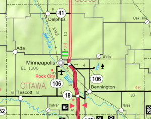 KDOT map of Ottawa County (legend) | |
| Coordinates: 39°16′29″N 97°45′59″W[1] | |
| Country | United States |
| State | Kansas |
| County | Ottawa |
| Founded | 1867 |
| Incorporated | 1884 |
| Named for | Delphos, Ohio |
| Area | |
| • Total | 0.64 sq mi (1.66 km2) |
| • Land | 0.62 sq mi (1.61 km2) |
| • Water | 0.02 sq mi (0.05 km2) |
| Elevation | 1,299 ft (396 m) |
| Population | |
| • Total | 359 |
| • Estimate (2016)[4] | 340 |
| • Density | 560/sq mi (220/km2) |
| Time zone | UTC-6 (CST) |
| • Summer (DST) | UTC-5 (CDT) |
| ZIP code | 67436 |
| Area code | 785 |
| FIPS code | 20-17600 [1] |
| GNIS ID | 0476142 [1] |
History
Delphos was founded in 1867 by Levi and Dan Yockey. The two brothers moved to the area from Delphos, Ohio and named the new community for their hometown.[7] Many settlers came to the area looking for a fresh start after the Civil War.
Geography
Delphos is located at 39°16′29″N 97°45′59″W (39.274770, -97.766377).[1] According to the United States Census Bureau, the city has a total area of 0.64 square miles (1.66 km2), of which, 0.62 square miles (1.61 km2) is land and 0.02 square miles (0.05 km2) is water.[2]
The city is located on the Solomon River and is five miles west of U.S. Route 81.
Demographics
| Historical population | |||
|---|---|---|---|
| Census | Pop. | %± | |
| 1880 | 256 | — | |
| 1890 | 561 | 119.1% | |
| 1900 | 648 | 15.5% | |
| 1910 | 767 | 18.4% | |
| 1920 | 870 | 13.4% | |
| 1930 | 678 | −22.1% | |
| 1940 | 714 | 5.3% | |
| 1950 | 676 | −5.3% | |
| 1960 | 619 | −8.4% | |
| 1970 | 599 | −3.2% | |
| 1980 | 570 | −4.8% | |
| 1990 | 494 | −13.3% | |
| 2000 | 469 | −5.1% | |
| 2010 | 359 | −23.5% | |
| Est. 2016 | 340 | [4] | −5.3% |
| U.S. Decennial Census | |||
Delphos is part of the Salina Micropolitan Statistical Area.
2010 census
As of the census[3] of 2010, there were 359 people, 161 households, and 104 families residing in the city. The population density was 579.0 inhabitants per square mile (223.6/km2). There were 222 housing units at an average density of 358.1 per square mile (138.3/km2). The racial makeup of the city was 96.4% White, 0.8% African American, 0.3% Native American, 0.8% from other races, and 1.7% from two or more races. Hispanic or Latino of any race were 2.2% of the population.
There were 161 households of which 22.4% had children under the age of 18 living with them, 55.9% were married couples living together, 6.8% had a female householder with no husband present, 1.9% had a male householder with no wife present, and 35.4% were non-families. 32.3% of all households were made up of individuals and 14.3% had someone living alone who was 65 years of age or older. The average household size was 2.23 and the average family size was 2.72.
The median age in the city was 48.7 years. 21.2% of residents were under the age of 18; 6.6% were between the ages of 18 and 24; 19% were from 25 to 44; 27.5% were from 45 to 64; and 25.6% were 65 years of age or older. The gender makeup of the city was 46.8% male and 53.2% female.
2000 census
As of the census[8] of 2000, there were 469 people, 200 households, and 137 families residing in the city. The population density was 766.8 people per square mile (296.9/km²). There were 238 housing units at an average density of 389.1 per square mile (150.6/km²). The racial makeup of the city was 98.93% White, 0.21% Native American, and 0.85% from two or more races. Hispanic or Latino of any race were 1.49% of the population.
There were 200 households out of which 26.0% had children under the age of 18 living with them, 59.0% were married couples living together, 6.0% had a female householder with no husband present, and 31.5% were non-families. 27.0% of all households were made up of individuals and 16.0% had someone living alone who was 65 years of age or older. The average household size was 2.35 and the average family size was 2.85.
In the city, the population was spread out with 23.2% under the age of 18, 7.9% from 18 to 24, 22.8% from 25 to 44, 23.0% from 45 to 64, and 23.0% who were 65 years of age or older. The median age was 42 years. For every 100 females, there were 99.6 males. For every 100 females age 18 and over, there were 92.5 males.
The median income for a household in the city was $31,563, and the median income for a family was $39,038. Males had a median income of $27,292 versus $18,438 for females. The per capita income for the city was $14,801. About 8.8% of families and 9.6% of the population were below the poverty line, including 6.7% of those under age 18 and 12.5% of those age 65 or over.
Education
Delphos is served by USD 239 North Ottawa County Schools.[9]
Delphos schools were closed through school unification. The Delphos High School mascot was Delphos Maroons.[10]
Notable people
- Grace Bedell, credited with influencing Abraham Lincoln to grow his beard.
- Archie McKain, Major League baseball pitcher
References
- Geographic Names Information System (GNIS) details for Delphos, Kansas; United States Geological Survey (USGS); October 13, 1978.
- "US Gazetteer files 2010". United States Census Bureau. Archived from the original on 2012-01-25. Retrieved 2012-07-06.
- "U.S. Census website". United States Census Bureau. Retrieved 2012-07-06.
- "Population and Housing Unit Estimates". Retrieved June 9, 2017.
- "2010 City Population and Housing Occupancy Status". U.S. Census Bureau. Retrieved October 12, 2011.
- Sunday evening in Delphos, Kansas, Kansas Historical Society, 2008. Accessed 2009-01-10.
- "Our History". Kansas Skyways. Archived from the original on 5 May 2014. Retrieved 4 May 2014.
- "U.S. Census website". United States Census Bureau. Retrieved 2008-01-31.
- "North Ottawa County Schools". USD 239. Archived from the original on 23 December 2016. Retrieved 7 January 2017.
- "10 Lettermen for Delphos High", The Salina Journal, 9 September 1951, p.18.
Further reading
External links
- City
- Schools
- USD 239, local school district
- Maps
- Delphos City Map, KDOT
Municipalities and communities of Ottawa County, Kansas, United States | ||
|---|---|---|
| Cities | 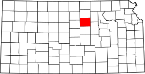 Map of Kansas highlighting Ottawa County | |
| CDP | ||
| Unincorporated communities | ||