Delmar, Iowa
Delmar is a city in Clinton County, Iowa, United States. The population was 525 at the 2010 census.
Delmar, Iowa | |
|---|---|
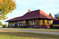 Chicago, Milwaukee, St. Paul & Pacific Depot | |
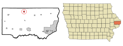 Location of Delmar, Iowa | |
| Coordinates: 42°0′6″N 90°36′28″W | |
| Country | United States |
| State | Iowa |
| County | Clinton |
| Government | |
| • Mayor | Patty Hardin |
| Area | |
| • Total | 0.76 sq mi (1.97 km2) |
| • Land | 0.76 sq mi (1.97 km2) |
| • Water | 0 sq mi (0 km2) |
| Elevation | 820 ft (250 m) |
| Population | |
| • Total | 525 |
| • Estimate (2018)[3] | 487 |
| • Density | 691/sq mi (266.7/km2) |
| Time zone | UTC-6 (Central (CST)) |
| • Summer (DST) | UTC-5 (CDT) |
| ZIP code | 52037 |
| Area code(s) | 563 |
| FIPS code | 19-19720 |
| GNIS feature ID | 0455873 |
History
Delmar was platted in 1871, shortly after the railroad was built through the site.[4] The name Delmar is said to be a combination of the names of six ladies on the first train to arrive into the station.[5] Le Mars, Iowa was similarly so named.[6]
Geography
Delmar is located at 42°0′6″N 90°36′28″W (42.001744, -90.607683).[7]
According to the United States Census Bureau, the city has a total area of 0.76 square miles (1.97 km2), all land.[1]
Demographics
| Historical populations | ||
|---|---|---|
| Year | Pop. | ±% |
| 1880 | 410 | — |
| 1890 | 518 | +26.3% |
| 1900 | 592 | +14.3% |
| 1910 | 548 | −7.4% |
| 1920 | 527 | −3.8% |
| 1930 | 480 | −8.9% |
| 1940 | 434 | −9.6% |
| 1950 | 415 | −4.4% |
| 1960 | 556 | +34.0% |
| 1970 | 599 | +7.7% |
| 1980 | 633 | +5.7% |
| 1990 | 517 | −18.3% |
| 2000 | 514 | −0.6% |
| 2010 | 525 | +2.1% |
| 2018 | 487 | −7.2% |
| Source:"U.S. Census website". United States Census Bureau. Retrieved 2020-03-29. and Iowa Data Center Source: | ||
2010 census
As of the census[2] of 2010, there were 525 people, 213 households, and 145 families living in the city. The population density was 690.8 inhabitants per square mile (266.7/km2). There were 227 housing units at an average density of 298.7 per square mile (115.3/km2). The racial makeup of the city was 97.0% White, 1.5% African American, 0.2% Native American, 0.2% Asian, and 1.1% from two or more races. Hispanic or Latino of any race were 1.5% of the population.
There were 213 households of which 33.8% had children under the age of 18 living with them, 54.0% were married couples living together, 8.0% had a female householder with no husband present, 6.1% had a male householder with no wife present, and 31.9% were non-families. 28.6% of all households were made up of individuals and 12.6% had someone living alone who was 65 years of age or older. The average household size was 2.46 and the average family size was 3.03.
The median age in the city was 38.5 years. 27% of residents were under the age of 18; 5.5% were between the ages of 18 and 24; 27.1% were from 25 to 44; 24.8% were from 45 to 64; and 15.6% were 65 years of age or older. The gender makeup of the city was 49.7% male and 50.3% female.
2000 census
As of the census[9] of 2000, there were 514 people, 195 households, and 141 families living in the city. The population density was 671.9 people per square mile (261.1/km²). There were 210 housing units at an average density of 274.5 per square mile (106.7/km²). The racial makeup of the city was 99.42% White, 0.19% Native American, 0.19% Asian, and 0.19% from two or more races. Hispanic or Latino of any race were 0.58% of the population.
There were 195 households out of which 37.9% had children under the age of 18 living with them, 60.5% were married couples living together, 7.7% had a female householder with no husband present, and 27.2% were non-families. 25.6% of all households were made up of individuals and 15.4% had someone living alone who was 65 years of age or older. The average household size was 2.64 and the average family size was 3.15.
30.9% are under the age of 18, 6.0% from 18 to 24, 27.6% from 25 to 44, 20.0% from 45 to 64, and 15.4% who were 65 years of age or older. The median age was 36 years. For every 100 females, there were 91.1 males. For every 100 females age 18 and over, there were 87.8 males.
The median income for a household in the city was $29,375, and the median income for a family was $37,750. Males had a median income of $28,125 versus $18,125 for females. The per capita income for the city was $14,469. About 7.5% of families and 6.7% of the population were below the poverty line, including 3.6% of those under age 18 and 18.4% of those age 65 or over.
Education
Delmar and Elwood Schools consolidated in 1962 to form the Delwood Community Schools. Delwood began whole-grade sharing with nearby Maquoketa in the 1980s, Students in grades 7-12 attend Maquoketa, while grades Pre-K through 6 remain at the Delwood School in Delmar.
See also
The following buildings in Delmar are listed on the National Register of Historic Places:[10]
- Chicago, Milwaukee, St. Paul & Pacific Depot- Delmar
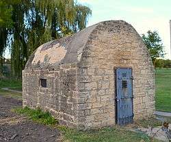
- Delmar Calaboose
References
- "US Gazetteer files 2010". United States Census Bureau. Archived from the original on 2012-01-25. Retrieved 2012-05-11.
- "U.S. Census website". United States Census Bureau. Retrieved 2012-05-11.
- "Population and Housing Unit Estimates". Retrieved March 17, 2020.
- Wolfe, Patrick B. (1911). Wolfe's History of Clinton County, Iowa, Volume 1. B. F. Bowen. pp. 267.
- The History of Clinton County, Iowa: Containing a History of the County, Its Cities, Towns &c. Western Historical Company. 1879. pp. 629.
- Chicago and North Western Railway Company (1908). A History of the Origin of the Place Names Connected with the Chicago & North Western and Chicago, St. Paul, Minneapolis & Omaha Railways. p. 63.
- "US Gazetteer files: 2010, 2000, and 1990". United States Census Bureau. 2011-02-12. Retrieved 2011-04-23.
- "Census of Population and Housing". Census.gov. Retrieved June 4, 2015.
- "U.S. Census website". United States Census Bureau. Retrieved 2008-01-31.
- "National Register Information System". National Register of Historic Places. National Park Service. July 9, 2010.
External links
| Wikimedia Commons has media related to Delmar, Iowa. |
- City website
- City-Data Comprehensive statistical data and more about Delmar
Municipalities and communities of Clinton County, Iowa, United States | ||
|---|---|---|
| Cities | Map of Iowa highlighting Clinton County | |
| Townships | ||
| Unincorporated communities | ||
| Footnotes | ‡This populated place also has portions in an adjacent county or counties | |