Dasbiyo
Dasbiyo (Arabic: داسبييو) is a town in southern Djibouti. It is served by a station on the old Ethio-Djibouti Railways. The surrounding district is rich in both livestock and fledgeling agriculture.
Dasbiyo داسبييو | |
|---|---|
Town | |
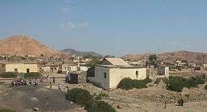 | |
 Dasbiyo داسبييو Location in Djibouti | |
| Coordinates: 11°15′N 42°47′E | |
| Country | |
| Region | Ali Sabieh |
| Elevation | 581 m (1,906 ft) |
| Population (2019) | |
| • Total | 1,750 |
History
This town has played an important role in trade between the port cities of Zeila, and the hinterland. Tumuli and vestiges have been found in and around Daasbiyo, once dynamic and prosperous possessing a well on its bed of wadi which crossed it. It was also a religious crossroads between the 10th and the 12th centuries, Islam only penetrated towards the end of the 13th century, whereas Zeila became much Muslim from the 6th century onwards.
Overview
Nearby towns and villages include Ali Sabieh (15 km), Holhol (18 km), Goubetto (35 km), Guelile (25 km) and Ali Adde (22 km).
Demographics
The population of Dasbiyo has been estimated to be 1,750. The town inhabitants belong to various mainly Afro-Asiatic-speaking ethnic groups, with the Issa Somali predominant.
Climate
Dasbiyo has a Semi-arid climate (BSh) in Köppen-Geiger system, it has warm winters and hot summers. Occasionally, Dasbiyo has heavy rains where the precipitation for the entire year will fall over the course of a few days.
| Climate data for Dasbiyo | |||||||||||||
|---|---|---|---|---|---|---|---|---|---|---|---|---|---|
| Month | Jan | Feb | Mar | Apr | May | Jun | Jul | Aug | Sep | Oct | Nov | Dec | Year |
| Average high °C (°F) | 26.3 (79.3) |
27.0 (80.6) |
28.4 (83.1) |
30.9 (87.6) |
34.0 (93.2) |
37.2 (99.0) |
37.5 (99.5) |
36.8 (98.2) |
32.8 (91.0) |
31.3 (88.3) |
27.6 (81.7) |
26.4 (79.5) |
31.4 (88.4) |
| Daily mean °C (°F) | 22 (72) |
23 (73) |
25 (77) |
27 (81) |
29 (84) |
31 (88) |
33 (91) |
32 (90) |
29 (84) |
27 (81) |
25 (77) |
23 (73) |
27 (81) |
| Average low °C (°F) | 16 (61) |
17 (63) |
18 (64) |
20 (68) |
22 (72) |
24 (75) |
26 (79) |
26 (79) |
24 (75) |
21 (70) |
18 (64) |
16 (61) |
21 (69) |
| Average rainfall mm (inches) | 10 (0.4) |
16 (0.6) |
20 (0.8) |
29 (1.1) |
3 (0.1) |
3 (0.1) |
18 (0.7) |
39 (1.5) |
23 (0.9) |
9 (0.4) |
27 (1.1) |
7 (0.3) |
204 (8) |
| Source: Climate-Data.org, altitude: 581m[1] | |||||||||||||
References
- "Climate: Dasbiyo - Climate graph, Temperature graph, Climate table". Climate-Data.org. Retrieved 30 September 2013.