Daraa District
Dar'a District (Arabic: منطقة درعا) is a district (mantiqah) administratively belonging to Daraa Governorate, Syria. At the 2004 Census it had a population of 428,681. Its administrative centre is the city of Daraa.
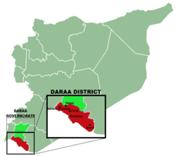
A map showing the districts of Daraa Governorate, figuring the Daraa District and the most important 5 cities of the district.
Sub-districts
The district of Daraa is divided into eight sub-districts or Nāḥiyas (population according to 2004 official census):
- Daraa Nahiyah (ناحية درعا): population 146,481.[1]
- Bosra Nahiyah (ناحية بصرى): population 33,839.[2]
- Khirbet Ghazaleh Nahiyah: (ناحية خربة غزالة) population 44,266.[3]
- Al-Shajara Nahiyah (ناحية الشجرة): population 34,206.[4]
- Da'el Nahiyah (ناحية داعل): population 43,691.[5]
- Muzayrib Nahiyah (ناحية مزيريب): population 72,625.[6]
- Al-Jiza Nahiyah (ناحية الجيزة): population 21,100.[7]
- Al-Musayfirah Nahiyah (ناحية المسيفرة): population 32,473.[8]
References
- "Daraa nahiyah population". Cbssyr.org. Archived from the original on 2012-02-07. Retrieved 2012-06-05.
- "Bosra nahiyah population". Cbssyr.org. Archived from the original on 2013-01-12. Retrieved 2012-06-05.
- "Kherbet Ghazaleh nahiyah population". Cbssyr.org. Archived from the original on 2013-01-12. Retrieved 2012-06-05.
- "Al-Shajarah nahiyah population". Cbssyr.org. Archived from the original on 2013-01-12. Retrieved 2012-06-05.
- "Da'el nahiyah population". Cbssyr.org. Archived from the original on 2013-01-12. Retrieved 2012-06-05.
- "Mzerib nahiyah population". Cbssyr.org. Archived from the original on 2012-12-09. Retrieved 2012-06-05.
- "Al-Jizah nahiyah population". Cbssyr.org. Archived from the original on 2013-01-12. Retrieved 2012-06-05.
- "Al-Musefra nahiyah population". Cbssyr.org. Archived from the original on 2013-01-12. Retrieved 2012-06-05.
This article is issued from Wikipedia. The text is licensed under Creative Commons - Attribution - Sharealike. Additional terms may apply for the media files.