Dallgow-Döberitz
Dallgow-Döberitz is a municipality in the Havelland district, in Brandenburg, Germany.
Dallgow-Döberitz | |
|---|---|
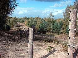 A view of the Döberitzer Heide | |
 Coat of arms | |
Location of Dallgow-Döberitz within Havelland district 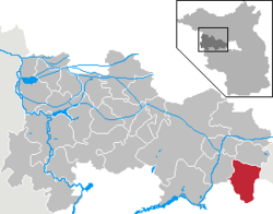 | |
 Dallgow-Döberitz  Dallgow-Döberitz | |
| Coordinates: 52°31′59″N 13°03′00″E | |
| Country | Germany |
| State | Brandenburg |
| District | Havelland |
| Government | |
| • Mayor | Jürgen Hemberger (Freie Wähler) |
| Area | |
| • Total | 65.96 km2 (25.47 sq mi) |
| Elevation | 37 m (121 ft) |
| Population (2018-12-31)[1] | |
| • Total | 9,931 |
| • Density | 150/km2 (390/sq mi) |
| Time zone | CET/CEST (UTC+1/+2) |
| Postal codes | 14624 |
| Dialling codes | 03322 |
| Vehicle registration | HVL |
| Website | www |
Geography
It consists of the villages of Dallgow-Döberitz, Rohrbeck and Seeburg. To the east it shares border with the Spandau borough of Berlin. Neighbouring Brandenburg municipalities are Falkensee in the north and Wustermark in the west. In the south is the large former proving ground Döberitzer Heide, now mainly a natural reserve governed by the Heinz Sielmann Foundation.
Districts of Dallgow-Döberitz
- Dallgow (with Neu-Döberitz)
- Rohrbeck
- Seeburg
History
The Imperial German Army established the proving ground in 1894 around the historic village of Döberitz, which had to be abandoned by its inhabitants. Its pioneering airfield was, in late 1915, the place where the world's first practical all-metal aircraft, the Junkers J 1, made its pioneering flights.
During the 1936 Summer Olympics in neighboring Berlin, it hosted the riding part of the modern pentathlon and part of the equestrian eventing competitions.[2]
Between 1945 and 1951 Dallgow served as East German border crossing for cars travelling along F 5 between the Soviet Zone of occupation in Germany (till 1949, thereafter the East German Democratic Republic) or the British Zone of Occupation (till 1949) and thereafter the West German Federal Republic of Germany and West Berlin. The traffic was subject to the Interzonal traffic regulations. After the East German Volkspolizei took control of West-Staaken on 1 February 1951 the checkpoint was moved up more eastwards.
The municipality shared its borders with the former West Berlin, and so during the period 1961-1990 it was separated from it by the Berlin Wall.
The 2008 film The Wave was filmed at the Marie Curie Gymnasium in this municipality.
Demography
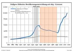 Development of Population since 1875 within the Current Boundaries (Blue Line: Population; Dotted Line: Comparison to Population Development of Brandenburg state; Grey Background: Time of Nazi rule; Red Background: Time of Communist rule)
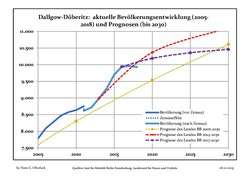 Recent Population Development and Projections (Population Development before Census 2011 (blue line); Recent Population Development according to the Census in Germany in 2011 (blue bordered line); Official projections for 2005-2030 (yellow line); for 2014-2030 (red line); for 2017-2030 (scarlet line)
| Dallgow-Döberitz: Population development within the current boundaries (2017)[3] | |||||||||||||||||||||||||||||||||||||||||||||||||||||||||||||||||||||||||||||||||||||||||||||||||||||||||||||||||||||||||||||||||||||||||
|---|---|---|---|---|---|---|---|---|---|---|---|---|---|---|---|---|---|---|---|---|---|---|---|---|---|---|---|---|---|---|---|---|---|---|---|---|---|---|---|---|---|---|---|---|---|---|---|---|---|---|---|---|---|---|---|---|---|---|---|---|---|---|---|---|---|---|---|---|---|---|---|---|---|---|---|---|---|---|---|---|---|---|---|---|---|---|---|---|---|---|---|---|---|---|---|---|---|---|---|---|---|---|---|---|---|---|---|---|---|---|---|---|---|---|---|---|---|---|---|---|---|---|---|---|---|---|---|---|---|---|---|---|---|---|---|---|---|
|
|
| |||||||||||||||||||||||||||||||||||||||||||||||||||||||||||||||||||||||||||||||||||||||||||||||||||||||||||||||||||||||||||||||||||||||
References
- "Bevölkerung im Land Brandenburg nach amtsfreien Gemeinden, Ämtern und Gemeinden 31. Dezember 2018". Amt für Statistik Berlin-Brandenburg (in German). July 2019.
- 1936 Summer Olympics official report. Volume 2. pp. 830, 894.
- Detailed data sources are to be found in the Wikimedia Commons.Population Projection Brandenburg at Wikimedia Commons
External links
![]()
Towns and municipalities in Havelland | ||
|---|---|---|
Coat of Arms of Havelland district | ||


| Authority control |
|
|---|