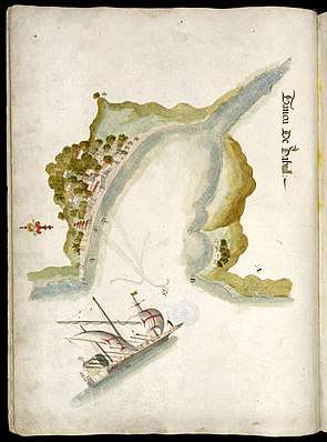
Dabhol
Dabhol, also known as Dabul (Marathi: दाभोळ), is a small seaport town in the Ratnagiri district of Maharashtra in India. It is located on the northern and southern sides of the Vashishthi river that later flows by Chiplun town.[1] The Dabhol LNG power plant that had been set up by Enron is located on the Southern side of Dabhol, between the villages of Veldur and Ranavi.[2]

History


Hardly a trace remains of the once-flourishing port of Dabhol (known as Dabul by the Portuguese and then the English), on the north bank of the mouth of the Vashishti River in the Konkan region of India. However, a larger Dabhol LNG terminal, unrelated to the ancient port is located on the Southern side of Vashishthi river. The Russian traveller Afanasy Nikitin/Athanasius Nikitin, who visited India (1468-1474) found Dabhol as a large town and extensive seaport. The horses from Mysore, Arabia, Khorasan and Nighostan were brought here for trade. This was the place which had links with all major ports from India to Ethiopia.[3]
In the 15th and 16th centuries, Dabul was an opulent Muslim trade centre, first under the Bahmani, later under the Adilshahi sultans of Bijapur. As the port with most convenient access to the Bahmani sultanate's capital at Bidar, Dabul's fortunes ascended quickly with that dynasty. At its height, it was arguably the most important port between Chaul and Goa.[4]
It was exactly the prominence of Dabul as a Muslim trade centre and port that led it to be bombarded, sacked and razed by a Portuguese expeditionary force (Battle of Dabul) under Francisco de Almeida in December, 1508, in a prelude to the famous Battle of Diu. Although the city's fort was not taken, it was only the first of several times, in the course of the next few decades, that the Portuguese tried to destroy Dabul. By the time of the last recorded attack, in 1571, the Governor of Dabhul was Khwaja Ali Shirazi. The battle led to killing 150 men at Dabhol.[3]
The break-up of the Bahmani state into several smaller Deccan sultanates had accelerated Dabul's decline. As new capitals for these statelets were erected, Dabul's geographic position was no longer as fortuitous as it had been before, and alternative, more convenient ports were cultivated. In the course of the 16th century, a lot of commerce was redirected away from Dabul and towards the rising new port of Rajapur further south.
The Dabhol port boasts of centuries old history. Dabhol was of great importance in the 14th, 15th and 16th centuries. It used to be the principal port of South Konkan region, carrying on trade with ports in the Mediterranean, the Red Sea and the Persian Gulf. During 13th to 15th centuries this port was ruled by the Bahamani dynasty and was known as Mustafabad. Later on it was Hamjabad and then it was Dabhol.[3]
Dabul was conquered by Shivaji around 1660 and annexed to the new Maratha kingdom.[3] The erection of the Anjanvel Fort Maratha fort of Anjnavel right across the river eclipsed whatever role remained for Dabul, and the once-great port city simply evaporated and disappeared from the maps.
Attempts to locate the historic port have sometimes led historians to mistakenly identify historic Dabul with modern Dapoli, an interior town several miles north of Dabhol.
Sadly, Dabhol's name was revived in the 1990s in association with the infamous Dabhol Power Station erected near the site by the Enron company.

Places Of Interest
Due to the confluence of Hindus and Muslims population, Dabhol contains a number of religious places of both Hindus and Muslims.
- Chandika Devi Mandir - Temple of Goddess Chandika, situated in a cave. The temple is believed to be a part of the ancient Dabhol fort. Remains of the fort wall can found at the entrance of temple premises. This is an underground temple. It is as old as Badami rock-cut temples.[3]
- Dabhol Jetty (Dhakka) - Until 80's this jetty was being used for a boat service from Mumbai. Now it is used by fishing boats & for ferry services between Dabhol - Veldur, Dabhol-Govalkot.
- Shahi Mosque - Also locally known as 'Anda Masjid'. A beautiful mosque built in dressed black trap stone. The mosque was built in 1659 by Ayesh Bibi, princess of Bijapur. The Mosque is classified as heritage building by archaeological department. Shahi Masjid, one of the oldest masjid in Kokan region. The masjid was built with dome and minarets standing close to the port which was built in Adilshah’s Regime by the Princess Aisha Bibi in 1659-60 by the builder Kamil Khan. It is said that Adilshah's Begum spent around 1.5 million rupees for the construction of this mosque. Shahi Masjid is an excellent example of Muslim architecture. There is a horse stable and fountain in good condition. Before 1800, Dabhol was said to be a famous port, but subsequently met with ruin due to wars and decreased trade.[3]
- Sai Baba Mandir - The temple of god Sai Baba, located in Dhorsai.with dome and minarets standing close to the port which was built in Adilshah's Regime by the Princess Aisha Bibi in 1659-60 by the builder Kamil Khan. It is said that Adilshah's Begum spent around 1.5 million rupees for the construction of this mosque. Shahi Masjid is an excellent example of Muslim architecture. During that time, Dabhol was said to be famous, but subsequently met with ruin due to wars and decreased trade.[3]
People
Dabhol is broadly divided into three parts i.e. Kumbharwadi, Banme Mohalla, Kharwadi, Bhandarwada, Bajarpeth & Varcha Mohalla. The Interior of Varcha Mohalla is further divided into many Mahullas (groups of families), such as Bamne Mahulla, Vankar Mahulla, and Tamdi Mahulla. The Bamne's are believed to be the Bahamani people. Over a period of time name changed from Bahamani to Bamne. It has mix population of Hindus & Muslims. People live a very simple life, with majority of them having occupations like fishing, supply of Alphonso Mangoes, Coconuts, Cashew Nuts, etc. As of now 2012, it has good population. Nowadays due to proper job openings from Companies like Bharati Shipyard, the living standard has risen significantly.
How to reach Dabhol
Dabhol is situated around 27 km from Dapoli. State Transport (ST) buses / private shared jeeps, rickshaws run between Dapoli and Dabhol. You can hire an auto rickshaw or drive down. Rented jeeps / cars are available. One can reach Dabhol through Ferry boat service from Dhopave, village across the creek which has connectivity to Guhaghar & Chiplun.
Directions from Dapoli to Dabhol:
- From Dapoli Bus Stand, take the second left at 'Kelaskar Naka' towards Dabhol
- Continue on the straight road to Dabhol
(Road Route: Dapoli – Kelaskar Naka – Jalgaon – Nante – Vanaushi – Dabhol)


Notes
- Minority StaffCommittee on Government Reform. "FACT SHEET - Background on Enron's Dabhol Power Project (22 February 2002)" (PDF). U.S. House of Representatives. Archived from the original (PDF) on 25 October 2016. Retrieved 25 October 2016.
- "Map of Dabhol and Enron LNG project". Google maps. Retrieved 25 October 2016.
- "Maharashtra Sytate Gazetteers-Ratnagiri District". Government of Maharashtra. Retrieved 25 December 2019.
- For a brief discussion of the decline of the port of Dabul, see Dames (1918: p.164) and Nairne (1873).
Sources
- Dames, M.L. (1918) "Introduction" in An Account Of The Countries Bordering On The Indian Ocean And Their Inhabitants, Vol. 1 (Engl. transl. of Livro de Duarte de Barbosa), 2005 reprint, New Delhi: Asian Education Services.
- Nairne, A.K. (1873), "Musalman Remains in the South Konkan", The Indian Antiquary, Vol. 2, p. 278-83 article
External links
Read about Dabhol in 'ऐतिहासिक दाभोळ: वर्तमान व भविष्य (Historic Dabhol: Present and Future)' book by Anna Shirgaonkar - a Konkani historian.[1]
- "Anna Shirgaonkar Research". Archived from the original on 6 September 2019.