Cururupu
Cururupu is a municipality in the state of Maranhão in the Northeast region of Brazil.[1][2][3][4]
Cururupu | |
|---|---|
Municipality | |
Flag of Cururupu | |
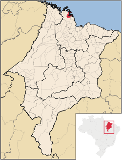 Location in Maranhão | |
| Country | |
| Region | Nordeste |
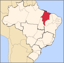
| State | Maranhão |
| Mesoregion | Norte Maranhense |
| Area | |
| • Total | 361 sq mi (936 km2) |
| Time zone | UTC -3 |
The waters offshore from the municipality contain the 45,937 hectares (113,510 acres) Parcel de Manuel Luís Marine State Park, created in 1991 to protect the largest coral reef of South America.[5]
See also
References
- "Divisão Territorial do Brasil" (in Portuguese). Divisão Territorial do Brasil e Limites Territoriais, Instituto Brasileiro de Geografia e Estatística (IBGE). July 1, 2008. Retrieved December 17, 2009.
- "Estimativas da população para 1º de julho de 2009" (PDF) (in Portuguese). Estimativas de População, Instituto Brasileiro de Geografia e Estatística (IBGE). August 14, 2009. Retrieved December 17, 2009.
- "Ranking decrescente do IDH-M dos municípios do Brasil" (in Portuguese). Atlas do Desenvolvimento Humano, Programa das Nações Unidas para o Desenvolvimento (PNUD). 2000. Archived from the original on October 3, 2009. Retrieved December 17, 2009.
- "Produto Interno Bruto dos Municípios 2002-2005" (PDF) (in Portuguese). Instituto Brasileiro de Geografia e Estatística (IBGE). December 19, 2007. Archived from the original (PDF) on October 2, 2008. Retrieved December 17, 2009.
- Edison Lobão; Fernando César de Moreira Mesquita (11 June 1991), Decreto nº 11.902 de 11 de Junho de 1991 (PDF) (in Portuguese), State of Maranhão, retrieved 2016-08-03
This article is issued from Wikipedia. The text is licensed under Creative Commons - Attribution - Sharealike. Additional terms may apply for the media files.