Curlew Mountains
Situated between Boyle and Castlebaldwin, the Curlew Mountains (Irish: An Corrshliabh) are in northeastern Connacht.[1]
| Curlew Mountains | |
|---|---|
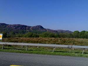 The Curlew Pass | |
| Highest point | |
| Elevation | 259 m (850 ft) |
| Prominence | 197 m (646 ft) |
| Geography | |
| Location | County Roscommon, Republic of Ireland |
| Parent range | Curlew Mountains |
Toponymy
The assignation of the name Curlew to the mountains may not relate the Curlew bird, but rather to the Irish: corrshliabh which means "steep-sided pointed mountatins".[2]
Geography
Geologically, the Curlew Mountains are made of Devonian sandstone and conglomerate that is harder than the surrounding Carboniferous limestone, hence their appearance as an upland feature.[3]
History
The Battle of Curlew Pass, in which Irish forces led by Red Hugh O'Donnell defeated an English army of about 2000 was fought here on 15 August 1599.[4]
References
- Cotton (2017a).
- Mac Coitir, "Birds in Irish Place Names".
- Cotton (2017b).
- D'Alton (1845), pp. 221-226.
- Cotton, D (2017a). "Curlew Mountains". IT Sligo. Archived from the original on 8 October 2017. Retrieved 8 October 2017.CS1 maint: unfit url (link)
- Cotton, D (2017b). "Curlew Mountains (419 to 359 Ma)". IT Sligo. Archived from the original on 8 October 2017. Retrieved 8 October 2017.CS1 maint: unfit url (link)
- D'Alton, John (1845). The history of Ireland, from the earliest period to the year 1245, when the Annals of Boyle, which are adopted and embodied as the running text authority, terminate: With a brief essay on the native annalists, and other sources for illustrating Ireland, and full statistical and historical notices of the barony of Boyle. Dublin: author.
- Mac Coitir, Niall (27 February 2017). Ireland's Birds: Myths, Legends & Folklore. The Collins Press. ISBN 978-1848892989. OCLC 1078888226.
This article is issued from Wikipedia. The text is licensed under Creative Commons - Attribution - Sharealike. Additional terms may apply for the media files.