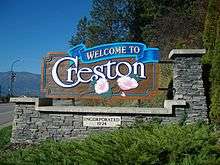
Creston, British Columbia
Creston is a town of 5,351 people in the Kootenay region of southeastern British Columbia, Canada. The town is located approximately 10 km (6 mi) north of the border crossing into the United States It is about a one-hour drive southwest from Cranbrook along the Crowsnest Highway. Due to its proximity to the U.S. border, many businesses in the town accept American currency. Similarly, Porthill, the nearby US border town, accepts Canadian currency and sells gasoline in litres.
Creston | |
|---|---|
| Town of Creston[1] | |
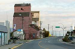 Elevators in Creston. | |
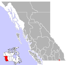 Location of Creston | |
| Coordinates: 49°05′24″N 116°30′36″W | |
| Country | Canada |
| Province | British Columbia |
| Region | Kootenays |
| Regional district | Central Kootenay |
| Incorporated | 1924 |
| Government | |
| • Governing body | Creston Town Council –Mayor Ron Toyota |
| Area | |
| • Total | 8.47 km2 (3.27 sq mi) |
| Elevation | 597 m (1,959 ft) |
| Population (2016) | |
| • Total | 5,351 |
| • Density | 626.8/km2 (1,623/sq mi) |
| Time zone | UTC−07:00 (MST[2]) |
| Postal code span | V0B |
| Area code(s) | 250 / 778 / 236 |
| Highways | |
| Waterways | Kootenay River |
| Website | Official website |
Creston is the eastern terminus of the Salmo-Creston highway constructed in the 1960s as a shortcut to avoid the long route north to Nelson and crossing Kootenay Lake on the Kootenay Lake Ferry between Balfour and Kootenay Bay. The Salmo-Creston highway, which is part of the Crowsnest Highway, connected with earlier highways eastward of Creston.
Creston is one of the few towns in British Columbia that does not observe daylight saving time.[2]
Economy
The Creston Valley's economy is largely resource-based with agriculture and forestry. Many are employed in the service sector, and tourism is increasingly prominent, while government services and education[3] comprise a large portion of the labour force. Since 1959, Kokanee beer has been brewed in Creston at the Columbia Brewery.[4] The town is also home to two grain elevators. Many apple, and cherry orchards grow in Erickson, an unincorporated area outside of Creston, and the valley is also an important dairy centre. The Creston Area produces the largest cherries grown in the northern hemisphere and exports them globally. A primary market is Europe while Asia is second. A number of growers sell the same product they export to Europe at their road side markets. The Skimmerhorn Winery[5] is now producing award-winning wines, and the valley includes other growers cultivating vines. Creston is home to CIDO-FM, a volunteer-run, locally based, community radio station, which broadcasts in town, and in the Creston Valley at 97.7 FM.
Demographics
| Canada 2016 Census | Population | % of total population | |
|---|---|---|---|
| Visible minority group Source:[6] |
Chinese | 10 | 0.2% |
| South Asian | 15 | 0.3% | |
| Black | 0 | 0% | |
| Filipino | 35 | 0.7% | |
| Latin American | 0 | 0% | |
| Arab | 0 | 0% | |
| Southeast Asian | 20 | 0.4% | |
| West Asian | 0 | 0% | |
| Korean | 0 | 0% | |
| Japanese | 0 | 0% | |
| Other visible minority | 0 | 0% | |
| Mixed visible minority | 0 | 0% | |
| Total visible minority population | 90 | 1.8% | |
| Aboriginal group Source:[7] | First Nations | 135 | 2.6% |
| Métis | 155 | 3% | |
| Inuit | 10 | 0.2% | |
| Total Aboriginal population | 310 | 6.1% | |
| European Canadian | 4,705 | 92.3% | |
| Total population | 5,105 | 100% | |
Climate
Creston has either an inland oceanic climate or a humid continental climate, depending on the isotherm used (0 or −3 °C (32 or 27 °F)). Creston's climate is often modified by air masses of the Pacific Ocean origin, especially in winter. Daily maximum temperatures are usually above freezing even in January except when air masses of Arctic origin move over the area. The worst cold outbreaks may send temperatures below −30 °C (−22 °F) on rare occasions. Spring comes early by Canadian standards; trees usually start to leaf out before the end of April. A clear summer day is likely to have a daily maximum near or above 25 °C (77 °F); the record maximum is 39.4 °C (103 °F). The first fall frost usually holds off until October where air drainage is good.
The mean annual precipitation is 662.4 mm (26.08 in) in mid-town, but the area has a rather steep precipitation gradient which is reflected in regional ecosystems.
| Climate data for Creston, 1981–2010 normals, extremes 1912–present | |||||||||||||
|---|---|---|---|---|---|---|---|---|---|---|---|---|---|
| Month | Jan | Feb | Mar | Apr | May | Jun | Jul | Aug | Sep | Oct | Nov | Dec | Year |
| Record high °C (°F) | 12.2 (54.0) |
14.0 (57.2) |
24.0 (75.2) |
30.0 (86.0) |
36.7 (98.1) |
37.8 (100.0) |
39.4 (102.9) |
38.7 (101.7) |
35.6 (96.1) |
27.0 (80.6) |
17.8 (64.0) |
13.3 (55.9) |
39.4 (102.9) |
| Average high °C (°F) | 1.1 (34.0) |
3.7 (38.7) |
9.3 (48.7) |
15.0 (59.0) |
19.6 (67.3) |
22.9 (73.2) |
27.2 (81.0) |
27.4 (81.3) |
21.4 (70.5) |
13.2 (55.8) |
5.0 (41.0) |
0.3 (32.5) |
13.9 (57.0) |
| Daily mean °C (°F) | −1.6 (29.1) |
0.0 (32.0) |
4.4 (39.9) |
8.8 (47.8) |
13.0 (55.4) |
16.4 (61.5) |
19.7 (67.5) |
19.6 (67.3) |
14.4 (57.9) |
7.9 (46.2) |
2.0 (35.6) |
−2.3 (27.9) |
8.5 (47.3) |
| Average low °C (°F) | −4.2 (24.4) |
−3.7 (25.3) |
−0.6 (30.9) |
2.7 (36.9) |
6.4 (43.5) |
9.8 (49.6) |
12.1 (53.8) |
11.7 (53.1) |
7.3 (45.1) |
2.6 (36.7) |
−1.1 (30.0) |
−4.9 (23.2) |
3.2 (37.8) |
| Record low °C (°F) | −32.8 (−27.0) |
−31.1 (−24.0) |
−21.7 (−7.1) |
−15.0 (5.0) |
−6.7 (19.9) |
−1.7 (28.9) |
1.7 (35.1) |
−0.6 (30.9) |
−7.2 (19.0) |
−20.0 (−4.0) |
−23.3 (−9.9) |
−30.6 (−23.1) |
−32.8 (−27.0) |
| Average precipitation mm (inches) | 68.6 (2.70) |
43.7 (1.72) |
49.4 (1.94) |
46.4 (1.83) |
64.6 (2.54) |
70.9 (2.79) |
39.9 (1.57) |
31.0 (1.22) |
41.5 (1.63) |
45.1 (1.78) |
84.0 (3.31) |
77.5 (3.05) |
662.4 (26.08) |
| Average rainfall mm (inches) | 30.3 (1.19) |
26.0 (1.02) |
41.8 (1.65) |
44.8 (1.76) |
64.6 (2.54) |
70.9 (2.79) |
39.9 (1.57) |
31.0 (1.22) |
41.5 (1.63) |
43.5 (1.71) |
59.0 (2.32) |
31.2 (1.23) |
524.5 (20.65) |
| Average snowfall cm (inches) | 38.3 (15.1) |
17.7 (7.0) |
7.5 (3.0) |
1.6 (0.6) |
0.0 (0.0) |
0.0 (0.0) |
0.0 (0.0) |
0.0 (0.0) |
0.0 (0.0) |
1.6 (0.6) |
25.0 (9.8) |
46.3 (18.2) |
137.9 (54.3) |
| Average precipitation days (≥ 0.2 mm) | 15.0 | 11.2 | 12.4 | 12.8 | 15.1 | 15.8 | 9.7 | 8.2 | 9.9 | 11.9 | 16.3 | 14.0 | 152.3 |
| Average rainy days (≥ 0.2 mm) | 7.6 | 7.6 | 11.1 | 12.8 | 15.1 | 15.8 | 9.7 | 8.2 | 9.9 | 11.9 | 13.2 | 6.1 | 129.0 |
| Average snowy days (≥ 0.2 cm) | 9.3 | 5.2 | 2.0 | 0.5 | 0.0 | 0.0 | 0.0 | 0.0 | 0.0 | 0.6 | 4.7 | 10.0 | 32.3 |
| Mean monthly sunshine hours | 51.1 | 89.6 | 140.2 | 189.1 | 236.3 | 242.5 | 300.7 | 290.0 | 212.9 | 145.5 | 58.7 | 41.0 | 1,997.5 |
| Percent possible sunshine | 18.9 | 31.3 | 38.1 | 46.0 | 49.9 | 50.1 | 61.6 | 65.0 | 56.2 | 43.3 | 21.3 | 15.9 | 41.5 |
| Source: Environment Canada[8][9] | |||||||||||||
Flora and fauna
The moisture-loving western hemlock grows near the town's northern boundary; another wet-belt indicator, the western red cedar, is common in the area. The sun-loving ponderosa pine forms a larger proportion of the vegetation near Creston's southern boundary. Douglas fir is the most common native tree throughout; other large conifers include grand fir, western larch, western white pine and lodgepole pine. Large pines other than the ponderosa are seldom seen in town, but are common in some of the woods nearby. The only native deciduous tree which matches the conifers in size is the black cottonwood. White birch and trembling aspen grow to medium size; smaller trees include the Rocky Mountain maple and bitter cherry. Prominent among the non-native trees are blue spruce, horsechestnut, Norway maple, silver maple, and several species of walnut, including the butternut. There also are occasional examples of catalpa, chestnut, London plane, and tulip tree.
Large mammals at Creston include cougar, bear, beaver, coyote, deer, elk, moose, muskrat and river otter.[10] More than 265 bird species occur in the Creston Valley, which is in a migration corridor for waterfowl such as goose and swan; the valley is also a wintering area for birds of prey.[11] The Creston area hosts British Columbia's only remaining population of northern leopard frog.[12]
Physiography and soils
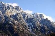
Creston is built on rolling bench-land immediately to the east of the Kootenay River floodplain. Beyond the bench-land to the east are the Purcell Mountains; their steep west-facing scarps are mistakenly called the Skimmerhorns, while the Selkirk Mountains rise west of the floodplain.
Silt loam is the most common soil texture at Creston. The floodplain soils are dark and poorly drained for the most part; they are excellent for pasture and grains where drainage is improved. Some of the bench-land soils are brown and of good tilth; others are gray, deficient in organic matter, and have rather heavy calcareous subsoils.
History
The Creston Valley has been inhabited by the Kutenai people for at least 11,000 years. The Kutenai are known for their unique language, the distinctive sturgeon-nosed canoe, and cultural traditions that blend a dependence on fish, small game, and waterfowl with the annual bison-hunting traditions of the Plains nations.
Exploration of the Creston Valley began in 1808, when David Thompson passed through the region, followed by fur traders, prospectors, and government surveyors. White settlement began in the early 1880s, and two railways, the Canadian Pacific Railway and Great Northern Railroad, built into the valley in the last years of the century. When the CPR purchased land from Fred Little for construction of the railway in 1897-8, he made it a condition of the sale that the town be named after his home town in Iowa[13]:55
Agriculture and forestry were the primary industries of the new community. Mining attracted many people, but, like many other communities around the Kootenays, the mineral deposits of the Creston Valley were not large enough to support a significant mining industry here.
Small fruits and tree fruits were the principal agricultural products of the early decades of the 20th century, and the Creston Valley quickly gained a reputation for the quality, quantity, and variety of fruit. The neighbouring town of Wynndel, for example, was known as the "strawberry capital of the world" by 1912. Reclamation of the flats alongside the Kootenay River, west of Creston, in 1935 led to large-scale grain production, again with outstanding quality and yields. Today, many livestock, dairy, and hay operations also contribute to the Valley's agricultural industry.
Growth of the community followed the development of local industry. By 1899 hotels, stores, and restaurants were established, along with the first volunteer fire department. The first school was established in 1899; church services were being held by the early 1890s and the first church, outside of the missionary church on the Lower Kootenay Band reserve, was built in 1906. The first resident doctor, Dr. Henderson, arrived in 1908, and the first hospital opened in 1930. Creston has a lot of buildings, downtown, that are or feature Art Deco architecture, and is one of the art deco capitals of Western Canada (for its size). Creston was incorporated as a village in 1924, and as a town in 1965.
Notable current and former residents
- Winston Blackmore, polygamist sect leader[14]
- Johnny Bucyk, former NHL hockey player (Boston Bruins)
- Aaron Douglas, actor
- Pascale Hutton, actress
- Jamie Huscroft, former NHL hockey player
- Darren Jensen, former NHL goalie (Philadelphia Flyers)
- Jamie Rauch, producer
- Duncan Regehr, actor
- Edward Joseph Garland, Politician and Diplomat
Youth Programs
Sports
- Creston Combat Fitness[16]
- Creston Judo Club[17]
- Creston Curling Club
- Creston Ospreys Rowing Club
- Creston Valley Thundercats junior 'B' hockey team
- Creston Waves Swim club
- Creston Valley Skating Club
| Club | League | Sport | Venue | Established | Championships |
|---|---|---|---|---|---|
| Creston Valley Thunder Cats | KIJHL | ice hockey | Johnny Bucyk Arena | 1976 | 0 |
References
- "British Columbia Regional Districts, Municipalities, Corporate Name, Date of Incorporation and Postal Address" (XLS). British Columbia Ministry of Communities, Sport and Cultural Development. Archived from the original on July 13, 2014. Retrieved November 2, 2014.
- Naniamo Daily News. Not everyone's a big fan of annual daylight time switch. 2012-11-03. Retrieved 2012-11-03.
- "Statistics Canada". Archived from the original on 2016-01-09.
- "History" Archived 2013-10-13 at the Wayback Machine Columbia Brewery. Retrieved 2013-11-17.
- skimmerhorn.ca
- "Community Profiles from the 2011 Census, Statistics Canada – Census Subdivision". 2.statcan.gc.ca. 6 December 2010. Archived from the original on 10 April 2014. Retrieved 13 April 2013.
- "Aboriginal Peoples – Data table". 2.statcan.ca. 6 October 2010. Retrieved 13 April 2013.
- "Calculation Information for 1981 to 2010 Canadian Normals Data". Environment Canada. Retrieved 27 February 2017.
- "Creston WPCC". Environment Canada. Retrieved 27 February 2017.
- Things to see and do at the Creston Valley Wildlife Management Area - a 17,000 Acre Wetland of International Importance Archived 2007-08-17 at the Wayback Machine
- Creston Valley Wildlife Management Area Archived 2007-06-02 at the Wayback Machine
- Living Landscapes
- Akrigg, G.P.V.; Akrigg, Helen B. (1986), British Columbia Place Names (3rd, 1997 ed.), Vancouver: UBC Press, ISBN 0-7748-0636-2
- Global News. Inside Bountiful: Winston Blackmore. 2011-10-11. Retrieved 2012-11-03.
- 1746 44 Royal Canadian Engineers
- Creston Combat Fitness
- Creston Judo Club
External links
| Wikivoyage has a travel guide for Creston. |
| Subdivisions |  | |
|---|---|---|
| Communities | ||
| Metro areas and agglomerations |
| |
| ||
| Authority control |
|
|---|