Coward Springs
Coward Springs is a former railway station of the Central Australia Railway and associated settlement in the Far North region of South Australia, which has been privately developed as a camping ground. The name officially refers to a mound spring located nearby. It is situated on the Oodnadatta Track adjacent to the Wabma Kadarbu Mound Springs Conservation Park, within the locality of Stuarts Creek about 236 kilometres (147 mi) from Coober Pedy.[1][4]
| Coward Springs Stuarts Creek, South Australia | |
|---|---|
.jpg) Coward Springs, ca. 1935 | |
 Coward Springs | |
| Coordinates | 29°24′04″S 136°48′42″E[1] |
| Established | 1858 |
| Elevation | 18 m (59 ft)[1] |
| Time zone | ACST (UTC+9:30) |
| • Summer (DST) | ACDT (UTC+10:30) |
| Location | 236 km (147 mi) east of Coober Pedy |
| State electorate(s) | Stuart[2] |
| Federal Division(s) | Grey[3] |
| Footnotes | Location[4] |
Nomenclature and official status
It was named in 1858 by Peter Warburton, the South Australian Commissioner of Police, after Corporal Thomas Coward. As of 2019, the name "Coward Springs" officially refers to a mound spring and not to a locality or a historical feature such as a town.[5]
History
A government bore was completed on 16 July 1886.[6] It was 400 feet deep and the artesian water rose 15 feet into the air from the bore.[7] The salty water from the Great Artesian Basin had quickly corroded the bore head and bore casing and so by the 1920s millions of gallons of water flowed without control over the dry gibber plains, creating a wetland. A large pool formed where water bubbled from the corroded bore and was popular with railway passengers, crew, residents and locals alike. The bore was redrilled and relined in 1993 by the South Australian government and the flow rate was controlled and reduced. The current owners built the ‘natural spa’ to imitate the old pool. The water now flows from the rehabilitated bore through the ‘natural spa’ and into the wetland. The wetland has created its own dynamics and now is an oasis providing water and food, shelter and breeding areas for a wide range of wildlife. So far 99 plant species, 126 bird species and numerous small native mammals, reptiles, aquatic and terrestrial invertebrates have been recorded here.
Coward Springs had a school from 1888 to 1890 although it was probably better known for the Coward Springs Hotel that was licensed from 1887 to 1953. Historically, as the train pulled into the station, passengers were given directions to the 'pub' and the ‘bath’ (the latter is now well known as the ‘natural spa’). When the hotel was demolished in 1965 the timber and galvanised iron were sent to a pastoral property on the Nullarbor Plain.
Today
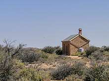
Coward Springs today is privately owned and operated as a campground and heritage area. The owner/managers successfully had the Coward Springs Railway Site listed in the South Australian Heritage Register on 13 August 1998.[8] The heritage site consists of two railway houses (the Engine Drivers Cabin and the Stationmasters House), two in-ground rainwater tanks, the bore, date palms and athel pines. All listed heritage components have been restored. The Stationmasters House is a private residence, the Engine Drivers Cabin - a two-roomed cabin - was classified as a ruin in the 1980s but was restored by the current owners in the 1990s and opened as a museum.
Although the present day date palms at Coward Springs reputedly were planted by pioneering "Afghan" cameleers, they are in fact remnants of two acres of date palms (variety Deglet Noor) planted there in 1898 as part of a South Australian government experimental plantation. Surviving date palms from this plantation (near the bore/'spa' and in the camping area) still produce fruit.
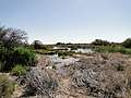 The wetlands
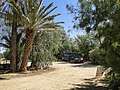 The camping area
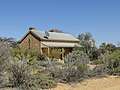 Former station master's house
References
- "Search results for 'Coward Springs Railway Station' with the following datasets being selected - 'Suburbs and Localities', 'Local Government Areas', 'SA Government Regions', 'Gazetteer' and 'Railways'". Location SA Map Viewer. Government of South Australia. Retrieved 21 March 2019.
- "District of Stuart Background Profile". ELECTORAL COMMISSION SA. Retrieved 20 August 2015.
- "Federal electoral division of Grey, boundary gazetted 16 December 2011" (PDF). Australian Electoral Commission. Retrieved 20 August 2015.
- "How to get there". Coward Springs Campground. Retrieved 24 June 2008.
- "Search results for 'Coward Springs (Spring)' with the following datasets being selected - 'Suburbs and Localities', 'Local Government Areas', 'SA Government Regions' and 'Gazetteer'". Location SA Map Viewer. Government of South Australia. Retrieved 22 March 2019.
- "Coward Springs". Flinders Ranges Research. Retrieved 24 June 2008.
- "Place Names of South Australia - C". Manning Index of South Australian History. State Library of South Australia. Retrieved 24 June 2008.
- "Coward Springs Railway Site". South Australian Heritage Register. Department of Environment, Water and Natural Resources. Archived from the original on 15 February 2016. Retrieved 12 February 2016.