Courtland, Minnesota
Courtland is a city in Nicollet County, Minnesota, United States. The population was 611 at the 2010 census.[7] It is part of the Mankato–North Mankato Metropolitan Statistical Area.
Courtland | |
|---|---|
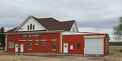 Courtland Creamery | |
| Motto(s): "A Great Place To Call Home"[1] | |
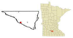 Location of Courtland, Minnesota | |
| Coordinates: 44°16′4″N 94°20′23″W | |
| Country | United States |
| State | Minnesota |
| County | Nicollet |
| Government | |
| • Type | Mayor – Council |
| • Mayor | Allen Poehler |
| Area | |
| • Total | 2.62 sq mi (6.78 km2) |
| • Land | 2.61 sq mi (6.76 km2) |
| • Water | 0.01 sq mi (0.02 km2) |
| Elevation | 935 ft (285 m) |
| Population | |
| • Total | 611 |
| • Estimate (2018)[4] | 698 |
| • Density | 265.31/sq mi (102.46/km2) |
| Time zone | UTC-6 (Central (CST)) |
| • Summer (DST) | UTC-5 (CDT) |
| ZIP code | 56021 |
| Area code(s) | 507 |
| FIPS code | 27-13582[5] |
| GNIS feature ID | 0642396[6] |
| Website | courtlandmn.com/ |
History
Courtland was platted in 1882.[8] The city was named for Cortland County, New York.[9]
Geography
According to the United States Census Bureau, the city has a total area of 2.64 square miles (6.84 km2), all of it land.[10]
Demographics
| Historical population | |||
|---|---|---|---|
| Census | Pop. | %± | |
| 1900 | 174 | — | |
| 1910 | 208 | 19.5% | |
| 1920 | 224 | 7.7% | |
| 1930 | 260 | 16.1% | |
| 1940 | 291 | 11.9% | |
| 1950 | 251 | −13.7% | |
| 1960 | 239 | −4.8% | |
| 1970 | 300 | 25.5% | |
| 1980 | 399 | 33.0% | |
| 1990 | 412 | 3.3% | |
| 2000 | 538 | 30.6% | |
| 2010 | 611 | 13.6% | |
| Est. 2018 | 698 | [4] | 14.2% |
| U.S. Decennial Census[11] 2018 Estimate[12] | |||
2010 census
As of the census[3] of 2010, there were 611 people, 237 households, and 176 families living in the city. The population density was 231.4 inhabitants per square mile (89.3/km2). There were 251 housing units at an average density of 95.1 per square mile (36.7/km2). The racial makeup of the city was 99.0% White, 0.2% African American, 0.7% Asian, and 0.2% from two or more races. Hispanic or Latino of any race were 0.7% of the population.
There were 237 households, of which 34.2% had children under the age of 18 living with them, 67.1% were married couples living together, 3.8% had a female householder with no husband present, 3.4% had a male householder with no wife present, and 25.7% were non-families. 19.4% of all households were made up of individuals, and 4.2% had someone living alone who was 65 years of age or older. The average household size was 2.58 and the average family size was 2.96.
The median age in the city was 37.7 years. 24.4% of residents were under the age of 18; 5.8% were between the ages of 18 and 24; 30.3% were from 25 to 44; 30.3% were from 45 to 64; and 9.3% were 65 years of age or older. The gender makeup of the city was 50.6% male and 49.4% female.
2000 census
As of the census[5] of 2000, there were 538 people, 188 households, and 150 families living in the city. The population density was 202.5 people per square mile (78.1/km2). There were 190 housing units at an average density of 71.5 per square mile (27.6/km2). The racial makeup of the city was 98.51% White, 1.12% Asian, 0.37% from other races. Hispanic or Latino of any race were 0.56% of the population.
There were 188 households, out of which 45.2% had children under the age of 18 living with them, 70.2% were married couples living together, 7.4% had a female householder with no husband present, and 20.2% were non-families. 17.0% of all households were made up of individuals, and 8.0% had someone living alone who was 65 years of age or older. The average household size was 2.86 and the average family size was 3.25.
In the city, the population was spread out, with 31.6% under the age of 18, 6.3% from 18 to 24, 31.2% from 25 to 44, 24.3% from 45 to 64, and 6.5% who were 65 years of age or older. The median age was 35 years. For every 100 females, there were 100.7 males. For every 100 females age 18 and over, there were 91.7 males.
The median income for a household in the city was $58,906, and the median income for a family was $66,184. Males had a median income of $40,000 versus $30,461 for females. The per capita income for the city was $23,267. About 1.4% of families and 2.6% of the population were below the poverty line, including 2.9% of those under age 18 and 10.5% of those age 65 or over.
References
- "City of Courtland Minnesota". City of Courtland Minnesota. Retrieved October 4, 2012.
- "2017 U.S. Gazetteer Files". United States Census Bureau. Retrieved January 3, 2019.
- "U.S. Census website". United States Census Bureau. Retrieved November 13, 2012.
- "Population and Housing Unit Estimates". Retrieved July 5, 2019.
- "U.S. Census website". United States Census Bureau. Retrieved January 31, 2008.
- "US Board on Geographic Names". United States Geological Survey. October 25, 2007. Retrieved January 31, 2008.
- "2010 Census Redistricting Data (Public Law 94-171) Summary File". American FactFinder. United States Census Bureau. Retrieved April 27, 2011.
- Upham, Warren (1920). Minnesota Geographic Names: Their Origin and Historic Significance. Minnesota Historical Society. p. 372.
- "Profile for Courtland, Minnesota, MN". ePodunk. Retrieved October 4, 2012.
- "US Gazetteer files 2010". United States Census Bureau. Archived from the original on July 2, 2012. Retrieved November 13, 2012.
- "Census of Population and Housing". Census.gov. Retrieved June 4, 2015.
- "Population Estimates". United States Census Bureau. Retrieved July 5, 2019.
External links
Municipalities and communities of Nicollet County, Minnesota, United States | ||
|---|---|---|
| Cities |  Map of Minnesota highlighting Nicollet County | |
| Townships | ||
| Unincorporated communities | ||
| Ghost town | ||
| Footnotes | ‡This populated place also has portions in an adjacent county or counties | |
| Core Cities |  | ||||
|---|---|---|---|---|---|
| Incorporated Places |
| ||||
| Counties | |||||
† indicates a county seat. ‡ indicates that it is partially in the metropolitan area. | |||||