Cottonwood Creek (San Diego County)
Cottonwood Creek is a major stream, about 36 miles (58 km) long,[1] in southern San Diego County, California. It is part of the Tijuana River drainage basin.
| Cottonwood Creek | |
|---|---|
 Location of Cottonwood Creek in California | |
| Location | |
| Country | United States |
| State | California |
| Physical characteristics | |
| Source | Laguna Mountains |
| ⁃ location | Cleveland National Forest |
| ⁃ coordinates | 32°49′56″N 116°27′57″W[1] |
| ⁃ elevation | 5,406 ft (1,648 m) |
| Mouth | Rio Alamar |
⁃ location | About 15 mi (24 km) east of Tijuana |
⁃ coordinates | 32°34′02″N 116°45′55″W[1] |
⁃ elevation | 558 ft (170 m) |
| Length | 36 mi (58 km)[1] |
| Basin size | 310 sq mi (800 km2)[2] |
| Discharge | |
| ⁃ location | near Dulzura[2] |
| ⁃ average | 15.2 cu ft/s (0.43 m3/s)[2] |
| ⁃ minimum | 0 cu ft/s (0 m3/s) |
| ⁃ maximum | 11,700 cu ft/s (330 m3/s) |
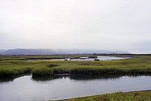
The creek begins in the Laguna Mountains, in the Cleveland National Forest near Pine Valley. It flows south through the Cottonwood Valley into Lake Morena, which is formed by Morena Dam. Below the dam it turns west, flowing through a narrow gorge to Barrett Lake, created by Barrett Dam. From there it turns south, passing Barrett Junction, before joining with Tecate Creek to form the Rio Alamar, a tributary of the Tijuana River. The confluence of the two streams is located only about 200 yards (180 m) north of the United States–Mexico border. Both Tecate Creek and the Alamar are located mostly in Mexico.[3]
_(19802273193).jpg)
Both Morena and Barrett Reservoirs are part of the San Diego, California municipal water supply system. Water travels from Cottonwood Creek via the Dulzura Conduit to Lower Otay Reservoir. Cottonwood Creek provides only a small fraction of San Diego's water supply, which mainly depends on imported Colorado River water.[4]
See also
References
- "Cottonwood Creek". Geographic Names Information System. United States Geological Survey. 1981-01-19. Retrieved 2016-12-08.
- "USGS Gage #11012000 on Cottonwood Creek above Tecate Creek, near Dulzura, CA" (PDF). National Water Information System. U.S. Geological Survey. 1936–2007. Retrieved 2016-12-08.
- USGS Topo Maps for United States (Map). Cartography by United States Geological Survey. ACME Mapper. Retrieved 2016-12-08.
- "San Diego Water Department Watershed Sanitary Survey" (PDF). City of San Diego. May 2003. Retrieved 2016-12-08.
 | Tributaries |  | |
|---|---|---|---|
| Waterworks |
| ||
| Geography |
| ||
| Protected areas | |||
| Cites, Communities, & Municipalities | |||
| Others | Pacific Coast Trail | ||