Conotton Creek
Conotton Creek (/kɒˈnɒtən/ kon-OT-ən) is a tributary of the Tuscarawas River, 38.7 miles (62.3 km) long, in eastern Ohio in the United States. Via the Tuscarawas, Muskingum and Ohio Rivers, it is part of the watershed of the Mississippi River, draining an area of 286 square miles (741 km²) in Carroll, Harrison and Tuscarawas County, Ohio. The source is at 1240 feet and the mouth is at 874 feet.[2] Dover Dam, downstream on the Tuscarawas river, is normally dry, but can impound a reservoir on Conotton and tributaries to a pool elevation of 916 feet for downstream flood control by the Corps of Engineers. From its source in eastern Harrison County, Ohio the creek flows west northwest through Jewitt, Scio, Conotton, Bowerston, Leesville, Sherrodsville, New Cumberland and Somerdale before reaching its mouth in central Tuscarawas County, Ohio. The Wheeling and Lake Erie Railway is situated in the valley. Ohio State Route 151 runs in the valley from near the source to Bowerston. Ohio State Route 212 run along the valley from Bowerston to the mouth. The Conotton Creek Trail runs from Bowerston to Jewett.
| Conotton Creek One Leg Creek | |
|---|---|
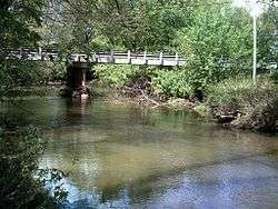 Connoton Creek flows under Ohio State Route 39 in Sherrodsville, Ohio | |
| Location | |
| Country | United States |
| State | Ohio |
| Physical characteristics | |
| Source | |
| ⁃ location | Green Township, Harrison County |
| ⁃ coordinates | 40°19′42″N 80°57′08″W[1] |
| ⁃ elevation | 1,240 ft (380 m)[2] |
| Mouth | Tuscarawas River |
⁃ location | Fairfield Township, Tuscarawas County |
⁃ coordinates | 40°34′34″N 81°23′32″W[1] |
⁃ elevation | 874 ft (266 m)[2] |
| Length | 38.7 mi (62.3 km)[2] |
| Basin size | 286 sq mi (740 km2)[2] |
The stream was declared navigable by the Ohio legislature in 1808, but the act was repealed in 1816, probably to allow the construction of mill dams.[3]
Variant names
According to the Geographic Names Information System, Conotton Creek has also been known historically as:[1]
- Connotten Creek
- Connotton Creek
- Conolton Creek
- Conoten Creek
- Gutgatsink Creek
- Kannotten Creek
- Kennottenhead Creek
- Knottenhead Creek
- One Leg Creek
Conotton Creek was known in the 19th century as One Leg Creek, named for an Indian who lived near its mouth.[3][4][5]
Named Tributaries and sub-Tributaries
| Tributary Name[2] | Flows Into[2] | Source Elevation feet[2] |
Mouth Elevation feet[2] |
Mouth Location[6] | Length miles[2] |
Drainage Area sq. Miles[2] |
notes |
|---|---|---|---|---|---|---|---|
| Huff Run | Conotton Creek | 1066 | 875 | 40°35′18″N 81°22′35″W | 9.9 | 13.9 | A, Mineral City, Morges, Lindentree |
| Beggar Run | Conotton Creek | 980 | 879 | 40°33′39″N 81°19′2″W | 2.7 | 4.45 | A |
| Dog Run | Conotton Creek | 1029 | 880 | 40°32′30″N 81°18′25″W | 3.5 | 2.94 | A |
| Indian Fork | Conotton Creek | 1116 | 887 | 40°31′18″N 81°17′40″W | 18.9 | 70.3 | A B Dellroy |
| Elliott Run | Indian Fork | 1040 | 916 | 40°33′58″N 81°12′38″W | 3.5 | 4.63 | B |
| Dellroy Creek | Indian Fork | 980 | 917 | 40°33′22″N 81°12′3″W | 1.5 | 1.3 | B |
| Willow Run | Indian Fork | 1040 | 919 | 40°33′59″N 81°11′48″W | 4.8 | 8.99 | B, a.k.a. Messer Run |
| Pleasant Valley Run | Indian Fork | 1080 | 936 | 40°33′18″N 81°9′17″W | 4.4 | 8 | B, New Harrisburg |
| Cold Spring Run | Indian Fork | 1146 | 953 | 40°33′59″N 81°7′43″W | 3.4 | 6.39 | |
| Town Creek | Indian Fork | 1120 | 974 | 40°33′52″N 81°4′58″W | 2.6 | 3.85 | Carrollton |
| Gant Creek | Indian Fork | 1116 | 974 | 40°33′26″N 81°5′37″W | 4.6 | 8.33 | |
| Thompson Run | Conotton Creek | 1060 | 903 | 40°30′07″N 81°14′58″W | 3.5 | 4.11 | A |
| Holmes Run | Conotton Creek | 1000 | 917 | 40°28′52″N 81°13′29″W | 2.2 | 2.65 | Leavittsville |
| McGuire Creek | Conotton Creek | 1230 | 920 | 40°28′30″N 81°13′3″W | 11.8 | 49.6 | C |
| North Fork McGuire Creek | McGuire Creek | 1218 | 927 | 40°28′20″N 81°11′35″W | 12.6 | 26.6 | C Petersburg |
| Bear Hole Run | North Fork McGuire Creek | 1071 | 948 | 40°30′44″N 81°8′52″W | 2.4 | 2.83 | C |
| Scott Run | Conotton Creek | 1200 | 947 | 40°24′59″N 81°8′39″W | 4.7 | 3.23 | |
| Dining Fork | Conotton Creek | 1270 | 974 | 40°24′25″N 81°6′12″W | 8 | 14.7 | Kilgore |
| Kirby Run | Dining Fork | 1235 | 974 | 40°25′23″N 81°4′57″W | 3.3 | 3.47 | |
| Irish Creek | Conotton Creek | 1240 | 967 | 40°23′37″N 81°4′52″W | 7.6 | 18.8 | a.k.a. Alder Creek, Snow Creek |
| Lick Fork | Irish Creek | 1237 | 998 | 40°24′40″N 81°2′7″W | 4 | 5.05 | New Rumley |
| Snow Creek | Irish Creek | 1240 | 1035 | 40°23′37″N 81°4′52″W | 3.4 | 4.72 | |
| Jefferson Creek | Conotton Creek | 1270 | 1116 | 40°22′2″N 80°59′46″W | 4.6 | 6.56 | Germano |
Note A
Dover Dam 40°33′26″N 81°24′44″W,[7] on Tuscarawas River is normally dry, but can inundate this waterway to a pool elevation of 916 feet for downstream flood control by the corps of engineers.[8]
Note B
Atwood Dam 40°31′36″N 81°17′5″W,[9] near the mouth of Indian Fork, impounds Atwood Lake to a normal pool elevation of 928 feet and a maximum elevation of 941 feet on this waterway.[8]
Note C
Leesville Dam40°28′6″N 81°11′41″W[10] sits on McGuire Creek and impounds Leesville Lake to a normal pool elevation of 963 feet and a maximum elevation of 977.5 feet on this waterway.[8]
References
- "Geographic Names Information System entry for Conotton Creek". Retrieved 2010-01-07.
- Ohio Department of Natural Resources. "GAZETTEER_OF_OHIO_STREAMS" (PDF). Retrieved 2010-01-07.
- Mansfield, J.B. (1884). The History of Tuscarawas County. Warner, Beers & Co. p. 669.
- History of Monroe Township, Carroll County, p.2-3
- Howe, Henry (1907). Historical Collections of Ohio, The Ohio Centennial Edition. The State of Ohio. p. 363.
henry howe.
- GNIS ID#1066759, 1060856, 1039735, 1066761, 1079578, 1039665, 1047963, 1044610, 1039240, 1047103, 1070756, 1066233, 1041680, 1066093, 1066113, 1037723, 1046069, 1066679, 1042299, 1066767, 1042531, 1066767, and 1066771
- GNIS Entry Dover Dam
- MWCD lake levels
- GNIS Entry Atwood Dam
- GNIS Entry Leesville Dam