Connecticut Route 11
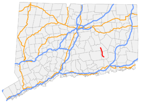
Route 11 (officially the ConnDOT Employees Memorial Highway and in the future to be the Salem—New London Greenway) is a state highway in east-central Connecticut, serving traffic between the Hartford and New London areas (which also use Route 2). Route 11 originally was planned to be a freeway/expressway, running northwest-to-southeast, from Colchester to Waterford. However, only about half of the freeway was constructed; one end is in Salem. As a result, many people in New London County, who would have benefitted most from the original project, derisively refer to the highway as Route 5½. [2]
| ||||
|---|---|---|---|---|
| ConnDOT Employees Memorial Highway (currently) Salem—New London Greenway (proposed) | ||||
 | ||||
| Route information | ||||
| Maintained by ConnDOT | ||||
| Length | 7.10 mi (11.43 km) | |||
| Existed | July 1971[1]–present | |||
| Major junctions | ||||
| South end | ||||
| North end | ||||
| Location | ||||
| Counties | New London | |||
| Highway system | ||||
| ||||

The delays, and eventual effective cancellation of the project in 2009, were due to funding and environmental issues. However, more recently, there has been a push to complete the expressway. This would be done by installing tolls on Route 11 to make up for the expenses.[3]
Route description
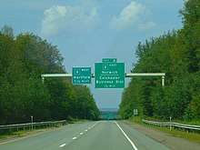
Route 11's southern terminus is the interchange with Route 82 (Exit 4) in the town of Salem. When completed, Route 11's southern terminus will be at an interchange with Interstate 95 and Interstate 395 in the town of East Lyme. It proceeds northward, soon crossing the Eightmile River. The road continues about 2.3 miles (3.7 km) crossing over Witch Meadow Road (Exit 5) at a diamond interchange, which leads to Salem center. Route 11 soon crosses into the town of Colchester, then has an interchange with Lake Hayward Road (Exit 6) about 2.8 miles (4.5 km) after crossing the town line. Lake Hayward Road, an unsigned state highway known as State Road 637, provides access to eastbound Route 2, Route 85, and Route 354. Northbound Route 11 merges onto westbound Route 2 0.6 miles later.[4]
History
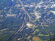
An expressway connecting Route 2 in Colchester and the Connecticut Turnpike in New London had been planned as far back as the 1950s. It was originally designated the Route 85 Expressway. Construction began in 1966 but was halted due to lack of funding. The half-finished expressway opened in 1972 as Route 11.[5]
Plans to finish Route 11 were revived in the late 1990s due to increased traffic in the area (primarily due to Foxwoods Resort Casino and Mohegan Sun). Contrary to local opposition to new highways, most of the residents of the area were in favor of completing the highway. Subsequently, Route 11 was submitted to the U.S. Department of Transportation for inclusion on the federal government's "fast-track" streamlining process, designed for federal agencies to quickly complete necessary steps on stalled projects, and was approved in August 2004. Funding for Route 11 has also been included in the proposed 2006 Connecticut state transportation bill. The State of Connecticut purchased, and still owns, the right-of-way for the project in Salem.
The Final Environmental Impact Statement for extending Route 11 was issued on October 26, 2007. The EIS was published three months behind schedule due to a dispute between ConnDOT and the consulting firm that prepared the EIS—the Macguire Group—over payment for services rendered.
A Record of Decision from federal officials was expected by the end of 2007,[6] but the Environmental Protection Agency had expressed concern over the environmental mitigation plan for Route 11, and expressed it still favored the Route 82/85 upgrade over extending Route 11. Because the EPA has veto power over Army Corps of Engineers permits, EPA opposition could have forced the delay or cancellation of the Route 11 extension. In December 2007, Federal Highway Administration extended the FEIS review period through the end of January 2008 to provide the EPA with a detailed environmental mitigation plan. Additionally state and federal elected officials requested the FHWA and ConnDOT present a detailed financial management plan for activities related to the extension. In September 2009, ConnDOT indicated that due to funding constraints, it will indefinitely suspend further work on Route 11.
In 2011, Governor Dan Malloy indicated that completing Route 11 to the I-95/I-395 interchange was a high priority for the state and ordered ConnDOT to resume environmental and funding studies. In August 2011, ConnDOT initiated a financial study that focused on building the Route 11 extension as a toll road, which could potentially accelerate construction of the extension by using a combination of funds from tolls and traditional state and federal highway funds.[7]
The final section of Route 11 was proposed to be built not to Interstate highway standards. While it would have been built as a fully controlled-access freeway, it would not have met Interstate standards due to two key design features: First, opposing lanes of traffic would have been separated by a concrete Jersey barrier versus the wide median on the existing Route 11 section. Secondly, the greenway was being planned to have curve radii that would have been tighter than what is allowed by Interstate standards, although it would have still had a design speed of 70 mph (110 km/h). With these two features, Route 11 would have been built using a footprint that was less than half the size required for an expressway built to Interstate standards.
The Route 11 Greenway Authority was created by the state legislature in 2000 as a committee designated with the responsibility of purchasing land on either side of the completed Route 11 to be preserved as hiking and biking trails and open space. As of 2010, the Authority still held monthly meetings and the funds from the State of Connecticut still existed to purchase land for the Greenway, despite the near certainty the expressway itself would never be completed. The Authority did not have the power of eminent domain. The cross-section profile for the Route 11 Greenway would have been similar to that of the Route 8 expressway through the Naugatuck State Forest between Beacon Falls and Naugatuck.
Unused bridges, roadbed and ramps
The northernmost mile (1.6 km) of the Route 11 extension would have been built more to Interstate standards as it transitioned between the Greenway profile and the profile of the existing segment ending at Exit 4 in Salem. When Route 11 opened to its present-day terminus at Route 82, crews had cleared and graded the roadbed for about a mile beyond Route 82 for the anticipated extension south, including two deep rock cuts and a pair of unused bridges over Route 82 just past present terminus. Two "ghost ramps" built during the 1970s would have been paved as the new roadway was built, creating full diamond interchange at Exit 4. The bridges, ramps, and rock cuts, as well as unused storm drains, were left behind when work stopped on Route 11 in 1972.
An interchange with Interstate 95 and 395 was also planned to be built as part of the highway extension, and accounted for about half of the $1 billion cost of the project.
Exit list
The entire route is in New London County.
| Location | mi | km | Exit | Destinations | Notes |
|---|---|---|---|---|---|
| Salem | 0.00 | 0.00 | 4 | At-grade intersection | |
| 0.65 | 1.05 | Bridge over the Eightmile River | |||
| 2.96 | 4.76 | 5 | Witch Meadow Road – Salem | ||
| Colchester | 7.10 | 11.43 | 6 | ||
| – | Exit 19 on Route 2 | ||||
| 1.000 mi = 1.609 km; 1.000 km = 0.621 mi | |||||
See also
References
- "'11' Reactivated as New Highway Route in State". The Bridgeport Post. July 25, 1971. p. 21. Retrieved January 21, 2020 – via Newspapers.com.

- https://www.nbcconnecticut.com/investigations/hidden-in-plain-sight-connecticut-roads-to-nowhere/124886/
- "Budget Deal Includes A Plan To Finish Route 11 And Install Tolls". tribunedigital-thecourant.
- "Connecticut State Highway Route Log (2006)" (PDF). Archived from the original (PDF) on 2011-09-27. Retrieved 2008-03-17.
- Scott Oglesby. "Connecticut Route 11".
- Key Step Forward for Route 11, New London Day, October 27, 2007 Archived May 24, 2011, at the Wayback Machine
- Route 11 Financial Study to Begin this Month Including the Distribution of Driver Surveys at Various Locations in Southeast Connecticut, Connecticut Department of Transportation, Aug 4, 2011
External links
