Colorado State Highway 92
State Highway 92 (SH 92) is a 73.22 miles (117.84 km) long state highway that runs between the small Colorado communities of Hotchkiss and Sapinero. SH 92's western terminus is at US 50 (US 50) in Delta, and the eastern terminus is at US 50 near Sapinero.[1]
| ||||
|---|---|---|---|---|
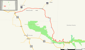 Map of western Colorado with SH 92 highlighted in red | ||||
| Route information | ||||
| Maintained by CDOT | ||||
| Length | 73.22 mi[1] (117.84 km) | |||
| Major junctions | ||||
| West end | ||||
| East end | ||||
| Location | ||||
| Counties | Delta, Montrose, Gunnison | |||
| Highway system | ||||
Colorado State Highways
| ||||

Route description
From SH 92's western terminus at mile 70.919 on US 50 in Delta, it proceeds eastward towards Hotchkiss. In Hotchkiss, it has an intersection with SH 133, and then SH 92 turns to travel in a more southeastern direction. After some time it turns back to the east and enters the Curecanti National Recreation Area. It then crosses the Gunnison River at Blue Mesa Reservoir. Proceeding eastward SH 92 reaches its eastern terminus at mile 131.129 on US 50 in the town of Sapinero
History
The route was established in the 1920s and was paved by 1975.[2]
Major intersections
| County | Location | mi | km | Destinations | Notes |
|---|---|---|---|---|---|
| Delta | Delta | 0.000 | 0.000 | Western terminus | |
| Read | 3.814 | 6.138 | Southern terminus of SH 65 | ||
| Hotchkiss | 20.725 | 33.354 | Southern terminus of SH 133 | ||
| Gunnison | Sapinero | 73.297 | 117.960 | Eastern terminus | |
| 1.000 mi = 1.609 km; 1.000 km = 0.621 mi | |||||
References
- "Segment list for SH 92". Retrieved 2008-10-19.
- Salek, Matthew E. "Colorado Routes 80-99". Retrieved 04-11-2010. Check date values in:
|accessdate=(help)