Colorado State Highway 144
State Highway 144 (SH 144) is a 28.796 mi (46.3 km) long state highway in northeastern Colorado. SH 144's western terminus is at Interstate 76 (I-76) west of Wiggins, and the eastern terminus is at SH 52 in Fort Morgan.
| ||||
|---|---|---|---|---|
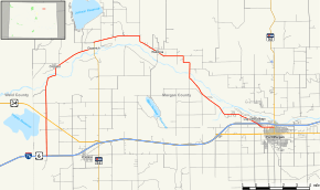 Map of Morgan County in northern Colorado with SH 144 highlighted in red | ||||
| Route information | ||||
| Maintained by CDOT | ||||
| Length | 28.796 mi[1] (46.343 km) | |||
| Major junctions | ||||
| West end | ||||
| ||||
| East end | ||||
| Location | ||||
| Counties | Morgan | |||
| Highway system | ||||
Colorado State Highways
| ||||

Route description
SH 144 begins in the west at I-76 and proceeds initially to the north; after 2.8 mi (4.5 km), the road crosses U.S. Route 34 (US 34). After another 3.8 mi (6.1 km), the route crosses the South Platte River and begins to curve in a broad arc to the east roughly following a meander of the South Platte. Continuing now in a generally westward direction, SH 144 meets the north end of SH 39 at Goodrich. The road then continues its arc westward and eventually WSW through Weldona, again across the South Platte River, and through Log Lane Village. Now traveling in approximately a southwesterly direction, SH 144 crosses to the south side of I-76 and continues for a further 1.4 mi (2.3 km) to its eastern terminus at SH 52 in Fort Morgan.
Major intersections
The entire route is in Morgan County.
| Location | mi[1] | km | Destinations | Notes | |
|---|---|---|---|---|---|
| | 0.000 | 0.000 | Western terminus; I-76 exit 60 | ||
| | 2.821 | 4.540 | |||
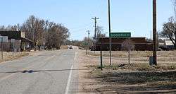
| Goodrich | 10.493 | 16.887 | Northern terminus of SH 39 | ||
| | 27.419 | 44.127 | I-76 exit 79 | ||
| Fort Morgan | 28.796 | 46.343 | Eastern terminus | ||
| 1.000 mi = 1.609 km; 1.000 km = 0.621 mi | |||||
References
- "Segment Descriptions for Highway 144". Colorado Department of Transportation. Retrieved 2008-03-27.