Colombia–Venezuela border
The Colombia–Venezuela border is an ongoing international border of 2219 kilometers (1378 mi) that separates the territories of Colombia and Venezuela, with a total of 603 milestones that demarcate the line.[1] It is the longest border of both Colombia and Venezuela.
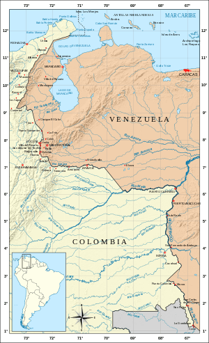
The border, at least in its terrestrial part, was essentially demarcated by two treaties: the Spanish Arbitration Award of Queen Maria Cristina of 1891 and the Treaty of Limits and River Navigation of 1941.[2] But the conflict still exists by the definition of border in the Gulf of Venezuela, and it still causes diplomatic clashes between both countries.
In August 2015, two Venezuelan soldiers were injured during a fight with alleged Colombian smugglers,[3] prompting Venezuelan President Nicolás Maduro to close a large part of the border, except in Táchira.[4]
Border cities
- Paraguachón, Maicao, Manaure del Cesar, Codazzi, Becerril, Tibú, Puerto Santander, Cúcuta, Villa del Rosario, Ragonvalia, Herrán, Cubará, Saravena, Arauquita, Arauca, Puerto Carreño, San José de Maipures, Inírida, Cacahual, Puerto Colombia, San Felipe, La Guadalupe.
- Paraguaipoa, Las Cruces, Casigua El Cubo, La Fría, San Juan de Colón, Ureña, San Antonio del Táchira, San Cristóbal, Rubio, Delicias, Guasdualito, El Amparo, Elorza, Puerto Páez, Puerto Ayacucho, Isla Ratón, San Fernando de Atabapo, Maroa, San Carlos de Río Negro.
Border rivers
The main rivers that cross or are part of the border are:[5]
- Río de Oro
- Catatumbo River
- San Pedro River
- Táchira River
- Nula River
- Arauca River
- Meta River
- Orinoco River
- Rio Negro
References
- Sociedad Geográfica de Colombia. "Frontera terrestre Colombia-Venezuela". Retrieved 27 July 2011.
- Monografías.com. "Límites de Venezuela". Retrieved 27 July 2011.
- Mundo, Redacción BBC. "Maduro ordena militarización de la frontera con Colombia "para acabar con el crimen"". BBC Mundo.
- Mundo, Redacción BBC. "Venezuela: Maduro decreta el estado de excepción en una parte de la frontera con Colombia". BBC Mundo.
- Revista La Timonera. "Fronteras terrestres y marítimas de Colombia". Retrieved 14 December 2013.
External links
| Wikimedia Commons has media related to Colombia-Venezuela border. |